El Niño is in place first time in four years, driving the outlook for warmer-than-average temperatures for the northern tier of the continental United States, according to NOAA’s U.S. Winter Outlook released today by the Climate Prediction Center—a division of the National Weather Service.
.gif)
According to NOAA Climate Prediction Center’s outlook for December-February 2022-23, the chances of a warmer-than-average winter (orange and red) are higher than the chances of a cooler-than-average winter across much of the northern part of the country, including Alaska, and most of Hawaii. White areas have equal chances for a relatively cool, warm, or average winter. Gray areas mean near-average temperatures are a little more likely than either warmer- or cooler-than-average temperatures. NOAA CPC map.
“These outlooks provide critical guidance on the upcoming season for many industries and sectors of our economy, from energy producers to commodities markets to agricultural interests to tourism,” said Sarah Kapnick, Ph.D., NOAA chief scientist. “With a strengthening El Niño and more potential climate extremes in an already record-breaking year, we’re lucky to have scientists like those at the Climate Prediction Center helping to build a Weather and Climate-Ready Nation by providing critical operational seasonal climate predictions.”
From December through February, NOAA predicts wetter-than-average conditions for northern Alaska, portions of the West, the southern Plains, Southeast, Gulf Coast and lower mid-Atlantic and drier-than-average conditions across the northern tier of the U.S., especially in the northern Rockies and High Plains and near the Great Lakes
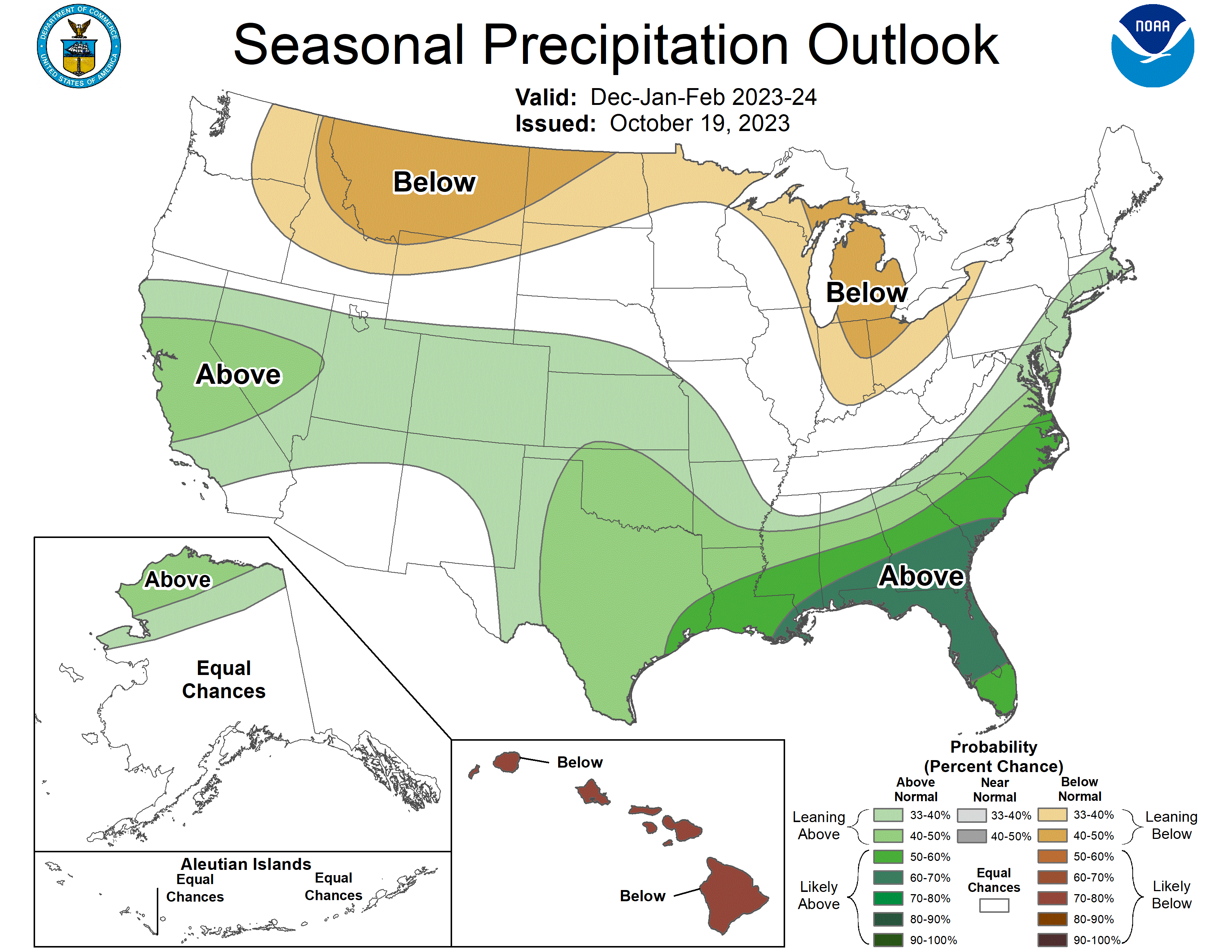
Out of three possible precipitation outcomes for the coming winter—much wetter than average, much drier than average, or near average—NOAA Climate Prediction Center’s outlook for December-February says that odds are leaning toward a much drier than average winter for – northern states from the Great Lakes to eastern Washington and toward a much wetter than average winter across the South, with the highest odds of a relatively wet winter in the Southeast. White areas mean equal chances for all three possible outcomes. NOAA Climate Prediction Center map.
“An enhanced southern jet stream and associated moisture often present during strong El Niño events supports high odds for above-average precipitation for the Gulf Coast, lower Mississippi Valley and Southeast states this winter,” said Jon Gottschalck, chief of the Operational Prediction Branch of the Climate Prediction Center.
NOAA forecasters, in collaboration with the National Integrated Drought Information System (NIDIS), continue to monitor extreme, ongoing drought conditions that have persisted through the southern and central U.S. and worsening drought in Hawaii.