Tornadoes and other circulations in Derecho environments
Tornadoes
Derechos and tornadoes can occur with the same convective system. This is particularly so with serial derechos associated with strong, migratory low pressure systems. The tornadoes may occur with isolated supercells (rotating thunderstorms) ahead of the derecho producing squall line, or they may develop from storms within the squall line itself. An example of a serial derecho that produced both extremely damaging straight-line winds and significant tornadoes from supercells embedded in the derecho-producing squall line is that which affected Florida during the early stages of the so-called “Storm of the Century” of March 12-13, 1993. Although not as common, tornadoes sometimes occur with progressive derechos. When they do, the tornadoes typically form within the bow echo storm system itself, and only rarely are associated with isolated supercells ahead of the bow.
The occurrence of tornadoes with derecho-producing convective systems reflects the fact that both tornadoes and strong convective wind gusts share, to some extent, common origins in the background atmospheric environment. In short, the great degree of thermodynamic instability; i.e., buoyancy, that gives rise to strong updrafts and, ultimately, the thunderstorms that spawn tornadoes also promotes the formation of storm downdrafts. In addition, both tornado and derecho environments are characterized by the presence of substantial vertical wind shear; i.e., large changes in wind speed and/or direction with height. While derecho-producing convective systems tend to be most favored when the vertical wind profile is unidirectional, a unidirectional wind profile may still contain appreciable shear. At the same time, in even a modestly sheared environment, small-scale stretching and tilting motions often present along storm gust fronts in a squall line may yield low-level circulations that, on occasion, can “tighten up” into a tornado.
Mesovortices
While storm downdrafts likely account for the greater proportion of damaging nontornadic winds in a derecho-producing convective system, observational evidence and numerical simulations show that corridors of enhanced wind damage in derecho-producing squall lines often are associated with embedded circulations or “vortices.” These features may occur in various sizes and generally are referred to as mesovortices.
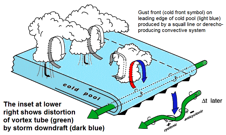
Mesovortices can arise in many ways. For example, the bookend vortices mentioned in Derecho-producing storms are counter-rotating circulations that arise as the rear-inflow jet of a developing convective system impinges on the system’s gust front (see Derecho development). This forces horizontally-rotating “tubes” of air along the gust front to tilt vertically in storm updrafts on either side of the jet. Once formed, the pair of resulting vortices can enhance the rear-inflow jet and thereby initiate or accelerate the bowing process, as shown here. Bookend circulations may reach dimensions of several tens of miles. Counter-rotating vortices also occasionally arise from the downward tilting of horizontal vorticity by storm downdrafts, as shown in the following schematic modified from this study by Wakimoto et al. The horizontal vortex tubes (here depicted by green arrows) arise from differencies in buoyancy strength (that is, the tendency for spontaneous upward motion) across a thunderstorm or squall line’s gust front.
Smaller circulations on the order of a mile or two in diameter sometimes develop along gusts fronts as a result of what is known as horizontal shear instability. This form of instability is derived from the very sharp changes in wind direction and speed that exist across such boundaries. When the background wind shear and/or buoyancy are great, shear-induced vortices sometimes sufficiently strengthen to produce tornado-like damage. Many such features accompanied the “Super Derecho” of May 8, 2009 (see Figure 4). Mesocirculations in some derecho-producing convective systems also may be traced to supercell storms that were present during the early stages of system development and subsequently were absorbed within it (e.g., see the “People Chaser Derecho” of 2001). Similar circulations appear when an accelerating line or bow echo overtakes a more slowly-moving supercell storm.
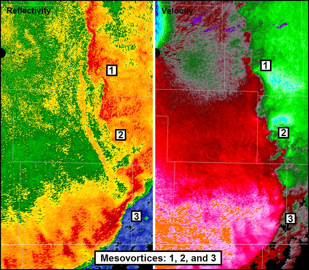
The split-panel illustration below shows several mesovortices along a derecho-producing squall line as viewed by Doppler radar. The left panel shows radar reflectivity, the right, radar velocity; the radar location is depicted by the black circles at the top left in both panels. Vortices 1 and 2 are small-scale circulations that may have arisen due to the presence of strong horizontal shear along the gust front. Green and blue shades in the velocity panel indicate air moving toward the radar; red and orange, air moving away. Vortex 3 is larger, but not as well-organized. Animated reflectivity data (not shown) suggest that this feature most likely is the residual circulation associated with a supercell storm that was overtaken by the convective system’s larger-scale, accelerating gust front. In the figure, this gust front appears as a sharply-outlined, arc-shaped swath of light red and pink shades in the lower right part of the velocity panel. It marks the leading edge of an expanding outrush of cold air associated with a well-developed, high wind-producing convective system. (Note: The thin, straight, white lines are county boundaries; the counties are roughly 20 statute miles wide, providing a length scale for the circulations shown).
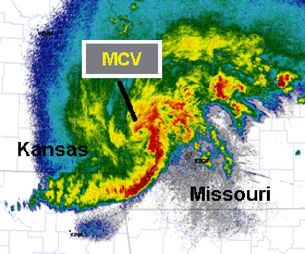
When a derecho-producing convective system becomes particularly large and long-lasting, a larger-scale circulation known as a mesoscale convective vortex or “MCV” may develop. These vortices arise from localized pressure falls that occur in response to the concentrated release of latent heat (i.e., warming) that accompanies the development of deep cumulonimbus clouds. On occasion MCVs may grow in size to occupy an area as large as that of a typical Midwestern state; such circulations may last for more than a day and enhance the convective system’s strength and longevity (e.g., the “Super Derecho” of 2009 previously mentioned). Smaller MCVs commonly form in weaker wind-producing systems. They often appear as swirls of residual mid-level clouds, or as bands of showers in radar imagery, long after the parent convection has dissipated. The radar reflectivity image below shows the very well-developed MCV associated with the “Super Derecho” of May 2009 as the circulation entered southwest Missouri from southeast Kansas.
Once developed, it is the superpositioning of vortex-induced winds with those of the convective system’s larger-scale outflow that can lead to corridors of enhanced damage in a derecho. Typically, with convective systems that form in the mid-latitudes where the mean tropospheric flow is westerly, this superpositioning yields the strongest winds on the equatorward side (i.e., the southern side in the Northern Hemisphere) of the vortices, where the wind fields are additive. An analogous additive effect accounts for the fact that the highest wind speeds in a hurricane generally occur in the storm’s right front quadrant (when facing in the direction of storm motion).