|
|
|
|
Morning newsletter
|
|
|
|
|
|
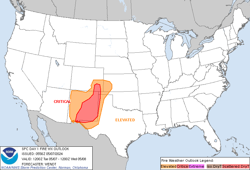
SPC Day 1 Fire Weather Outlook
|
|
|
|
SPC Day 1 Fire Weather Outlook Day 1 Fire Weather Outlook NWS Storm Prediction Center Norman OK 0159 AM CST Sun Jan 07 2024 Valid 071200Z - 081200Z ...NO CRITICAL AREAS... ...Synopsis... An amplified and progressive mid-level flow pattern will persist over the CONUS as a Pacific trough is forecast to rapidly deepen over parts of the western US before …
|
|
|
|
|
|
|
|
SPC Day 2 Fire Weather Outlook
|
|
|
|
SPC Day 2 Fire Weather Outlook Day 2 Fire Weather Outlook NWS Storm Prediction Center Norman OK 0205 AM CST Sun Jan 07 2024 Valid 081200Z - 091200Z ...Synopsis... An intense upper-level trough and surface low are forecast to amplify further as they move eastward across the south-central CONUS D2/Monday. In the wake of the low, a strong cold front …
|
|
|
|
|
|
|
|
SPC Jan 7, 2024 0600 UTC Day 1 Convective Outlook
|
|
|
|
SPC 1200Z Day 1 Outlook Day 1 Convective Outlook NWS Storm Prediction Center Norman OK 1122 PM CST Sat Jan 06 2024 Valid 071200Z - 081200Z ...NO SEVERE THUNDERSTORM AREAS FORECAST... ...SUMMARY... Severe thunderstorms are not forecast through early Monday morning. ...Discussion... A surface anticyclone over south-central TX will build east-northeast across the Deep South to the southern Appalachians through …
|
|
|
|
|
|
|
|
SPC Jan 7, 2024 0700 UTC Day 2 Convective Outlook
|
|
|
|
SPC 0700Z Day 2 Outlook Day 2 Convective Outlook NWS Storm Prediction Center Norman OK 1140 PM CST Sat Jan 06 2024 Valid 081200Z - 091200Z ...THERE IS A SLIGHT RISK OF SEVERE THUNDERSTORMS MONDAY INTO MONDAY NIGHT ACROSS PARTS OF SOUTHEASTERN TEXAS...SOUTHERN LOUISIANA...SOUTHERN MISSISSIPPI...SOUTHERN ALABAMA AND THE WESTERN FLORIDA PANHANDLE... ...SUMMARY... Severe thunderstorms, accompanied by a risk for damaging …
|
|
|
|
|
|
|
|
SPC Jan 7, 2024 0830 UTC Day 3 Severe Thunderstorm Outlook
|
|
|
|
SPC 0830Z Day 3 Outlook Day 3 Convective Outlook NWS Storm Prediction Center Norman OK 0215 AM CST Sun Jan 07 2024 Valid 091200Z - 101200Z ...THERE IS A SLIGHT RISK OF SEVERE THUNDERSTORMS TUESDAY ACROSS PARTS OF SOUTHEASTERN ALABAMA...MUCH OF NORTHERN AND CENTRAL FLORIDA THROUGH PORTIONS OF THE CAROLINA PIEDMONT AND COASTAL PLAIN... ...SUMMARY... Strong to severe thunderstorms may …
|
|
|
|
|
|
|
|
SPC Day 3-8 Fire Weather Outlook
|
|
|
|
SPC Day 3-8 Fire Weather Outlook Day 3-8 Fire Weather Outlook NWS Storm Prediction Center Norman OK 0257 PM CST Sat Jan 06 2024 Valid 081200Z - 141200Z A progressive upper-level pattern is expected through next weekend. Shortwave troughs are forecast to move across the southern U.S. periodically. This pattern will favor cool/cold conditions across northern/central portions of the CONUS …
|
|
|
|
|
|
|
|
SPC Jan 7, 2024 0100 UTC Day 1 Convective Outlook
|
|
|
|
SPC 0100Z Day 1 Outlook Day 1 Convective Outlook NWS Storm Prediction Center Norman OK 0647 PM CST Sat Jan 06 2024 Valid 070100Z - 071200Z ...NO SEVERE THUNDERSTORM AREAS FORECAST... ...SUMMARY... Severe thunderstorms are not expected through early Sunday. ...Discussion... Severe potential has waned since peaking a couple hours ago when a brief tornado was reported near FLL. Deep …
|
|
|
|
|
|
|
|
|
|