Tornado Watch issued May 7 at 4:57PM EDT until May 7 at 11:00PM EDT by NWS Cleveland OH
LEZ143 Reno Beach to The Islands OHTHE NATIONAL WEATHER SERVICE HAS ISSUED TORNADO WATCH 196 IN
EFFECT UNTIL 11 PM EDT THIS EVENING FOR THE FOLLOWING AREAS
THIS WATCH INCLUDES THE FOLLOWING ADJACENT COASTAL WATERS
MAUMEE BAY TO RENO BEACH OH
RENO BEACH TO THE ISLANDS OHhttps://api.weather.gov/alerts/urn:oid:2.49.0.1.840.0.be0fa4621d451188dcb9920ab5eae8d66e6060e1.002.1.cap5:02 pmMay 7, 2024
Tornado Watch issued May 7 at 4:57PM EDT until May 7 at 11:00PM EDT by NWS Cleveland OH
LEZ142 Maumee Bay to Reno Beach OHTHE NATIONAL WEATHER SERVICE HAS ISSUED TORNADO WATCH 196 IN
EFFECT UNTIL 11 PM EDT THIS EVENING FOR THE FOLLOWING AREAS
THIS WATCH INCLUDES THE FOLLOWING ADJACENT COASTAL WATERS
MAUMEE BAY TO RENO BEACH OH
RENO BEACH TO THE ISLANDS OHhttps://api.weather.gov/alerts/urn:oid:2.49.0.1.840.0.be0fa4621d451188dcb9920ab5eae8d66e6060e1.002.1.cap5:02 pmMay 7, 2024
Tornado Watch issued May 7 at 4:57PM EDT until May 7 at 11:00PM
THE NATIONAL WEATHER SERVICE HAS ISSUED TORNADO WATCH 196 IN EFFECT UNTIL 11 PM EDT THIS EVENING FOR THE FOLLOWING AREAS IN OHIO
THIS WATCH INCLUDES 8 COUNTIES IN NORTH CENTRAL OHIO CRAWFORD IN NORTHWEST OHIO HANCOCK LUCAS OTTAWA SANDUSKY SENECA WOOD WYANDOT THIS INCLUDES THE CITIES OF BELLEVUE, BOWLING GREEN, BUCYRUS, CAREY, CLYDE, CRESTLINE, FINDLAY, FOSTORIA, FREMONT, GALION, GENOA, OAK HARBOR, PERRYSBURG, PORT CLINTON, TIFFIN, TOLEDO, AND UPPER SANDUSKY.


Partly Cloudy and 75 F at Dayton / Wright-Patterson Air Force Base, OH

Winds are South at 11.5 MPH (10 KT). The pressure is 1004.2 mb and the humidity is 76%.
Last Updated on May 7 2024, 3:55 pm EDT.
Last Updated on May 7 2024, 3:55 pm EDT.
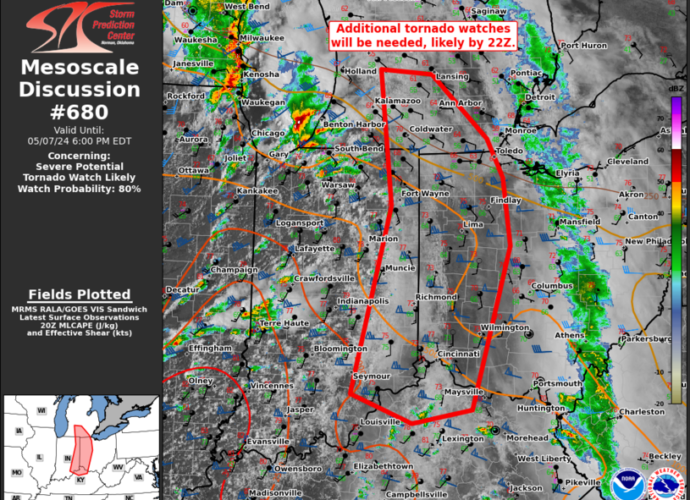
SPC MD 680
SPC Mesoscale Discussions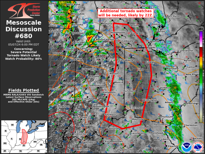
Mesoscale Discussion 0680
NWS Storm Prediction Center Norman OK
0333 PM CDT Tue May 07 2024

Areas affected...southern Lower MI...eastern IN...western OH...far
northern KY

Concerning...Severe potential...Tornado Watch likely

Valid 072033Z - 072200Z

Probability of Watch Issuance...80 percent

SUMMARY...As supercells spread quickly east-northeast from southern
Lower MI and northwest IN, an additional tornado watch/watches will
be needed prior to 22Z. This may also include a combined/separate
watch farther south in eastern IN/western OH ahead of supercells
intensifying over the Wabash Valley.

DISCUSSION...As mentioned in MCD 0679, an increasingly favorable
setup for supercells, a couple of which may be long-tracked, is
underway across northwest IN to the Wabash Valley. The northern
storms may being to outpace the rapid boundary-layer
warming/moistening that is occurring across northeast IN and
northwest OH into southern Lower MI. Nevertheless, the intense
mid-level jet will likely foster sustained supercells even as they
become slightly elevated towards southeast Lower MI. With backed
low-level flow and ample low-level shear (per IWX VWP data), the
tornado threat will remain prominent with any supercells along and
south of the surface warm front. A couple strong tornadoes are
possible.

..Grams/Smith.. 05/07/2024

...Please see www.spc.noaa.gov for graphic product...

ATTN...WFO...CLE...JKL...ILN...DTX...LMK...IWX...GRR...IND...

LAT...LON   42758544 42698458 41898367 41398340 40538329 38478394
            38308491 38688589 41048526 42758544
https://www.spc.noaa.gov/products/md/md0680.htmlSPC Mesoscale Discussions
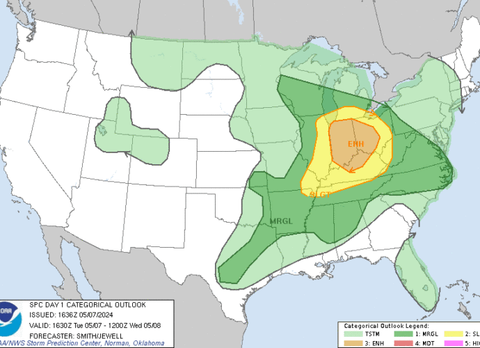
SPC May 7, 2024 1630 UTC Day 1 Convective Outlook
Day 1 Convective Outlook
NWS Storm Prediction Center Norman OK
1136 AM CDT Tue May 07 2024

Valid 071630Z - 081200Z

...THERE IS AN ENHANCED RISK OF SEVERE THUNDERSTORMS FOR
INDIANA...WESTERN AND CENTRAL OHIO...AND NORTHERN KENTUCKY...

...SUMMARY...
Scattered severe thunderstorms are expected across the southern
Great Lakes and Ohio Valley this afternoon and evening.  A few
tornadoes (some strong), large to very large hail, and
severe/damaging winds all appear possible.

...Southern Great Lakes/Ohio Valley and vicinity...
Considerable uncertainty remains for this forecast due largely in
part to an ongoing broken squall line moving east across KY/IN/Lake
Michigan and the related influences for airmass destabilization in
its wake.  However, clearing skies in the MCS' wake will result in a
seemingly sufficient period of heating during the afternoon.
Water-vapor imagery shows the deep-layer cyclone centered over the
northern Great Plains.  A mid-level speed max rotating through the
base of the larger-scale trough will move from the mid MS Valley
late this morning into the southern Great Lakes by early evening.
Rapid strengthening of southwesterly 500-mb flow is forecast over
northern IL into the northern half of IN through the mid-late
afternoon.  As an effective warm frontal zone becomes draped across
the southern Great Lakes/OH Valley regions, curved low-level
hodographs beneath a lengthening of the mid and upper part of the
hodograph will support a supercell risk.  It seems most probable
based on morning model guidance that storms will initially develop
across central/northern IL and move northeast into northern IN.
Isolated to scattered storms are forecast to eventually develop this
afternoon across parts of the OH Valley in association with
warm/moist-air advection---although considerable uncertainty remains
regarding this scenario.  The stronger storms (i.e., supercells)
will be potentially capable of a large to very large hail threat, in
addition to several tornadoes (perhaps a few which may be strong).

...Arklatex to north-central and south-central TX...
Not much change in the forecast thinking across the Mid South
southwestward into parts of TX.  Isolated severe thunderstorms are
possible during mid/late afternoon.  Damaging gusts and large hail
would be the main concerns.  The threat over the area is conditional
-- more due to weak lift than thermodynamic considerations.  Surface
dewpoints commonly in the 70s F will underlie a deep troposphere and
enough middle-level lapse rates for MLCAPE in the 3500-4500 J/kg
range.  Weak low-level winds will constrain hodograph size and
boundary- layer shear.  However, enough mid/upper flow remains to
support around 45-55 kt effective-shear magnitudes, yielding a
conditional supercell environment.  In the absence of meaningful
large-scale support, and with shallower overall lift near the
front/dryline, convective coverage over this region is more in
question and likely isolated.  Additional convection may form
overnight in a warm-advection plume near and southeast of the front,
across parts of the Mid-South to Arklatex regions.  Marginal hail
and isolated damaging gusts would be the main concerns.

...Southeast KS late tonight...
A strengthening LLJ and associated warm-air advection will be
focused over the northeast OK/southeast KS region late tonight.
Forecast soundings show large MUCAPE amidst strong deep-layer shear.
Large hail may accompany a stronger storm or two that manages to
develop/become sustained during the 08-12z period.

..Smith/Jewell.. 05/07/2024