SPC – No MDs are in effect as of Tue May 7 06:30:08 UTC 2024
2024-05-07
SPC Mesoscale Discussions
No Mesoscale Discussions are in effect as of Tue May 7 06:30:08 UTC 2024.
https://www.spc.noaa.gov/products/md/SPC Mesoscale Discussions

Mostly Cloudy and 64 F at Dayton / Wright-Patterson Air Force Base, OH
2024-05-07

Winds are Northeast at 5.8 MPH (5 KT). The pressure is 1010.4 mb and the humidity is 92%.
Last Updated on May 7 2024, 12:55 am EDT.
Winds are Northeast at 5.8 MPH (5 KT). The pressure is 1010.4 mb and the humidity is 92%.
Last Updated on May 7 2024, 12:55 am EDT.
Last Updated on May 7 2024, 12:55 am EDT.

SPC Day 3-8 Fire Weather Outlook
2024-05-07
SPC Day 3-8 Fire Weather Outlook
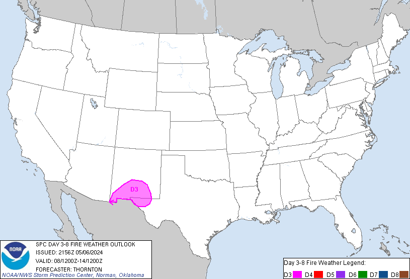
Day 3-8 Fire Weather Outlook
NWS Storm Prediction Center Norman OK
0456 PM CDT Mon May 06 2024

Valid 081200Z - 141200Z

Critical fire weather conditions will persist on D3/Wednesday, as a
westerly downslope flow regime continues over the central/southern
High Plains. A continental air mass overspreads the central/southern
Plains beyond D3/Wednesday, which will limit fire weather concerns
in the extended. Elsewhere across the country, widespread
precipitation chances and/or recent rainfall will limit fire weather
concerns.

...D3/Wednesday - Southern High Plains...
On D3/Wednesday, a cold front will move southward into the
south-central Plains. Westerly winds sustained around 15-25 mph and
relative humidity in the single digits to teens will overlap dry
fuels in southern New Mexico, where surface pressure gradients are
the strongest. 40-70% probabilities were maintained with this
outlook to cover this potential for Critical fire weather
conditions.

Beyond D3/Wednesday, a cooler continental air mass will continue to
push into the southern Plains with weakening zonal flow aloft. Areas
of dry/breezy conditions are possible, but will likely be confined
to eastern AZ/southwest NM. Rain chances are forecast to increase
towards the end of the work week across the Four Corners/southern
High Plains, which should further limit fire potential.

..Thornton.. 05/06/2024

...Please see www.spc.noaa.gov/fire for graphic product...
SPC MD 671
2024-05-07
SPC Mesoscale Discussions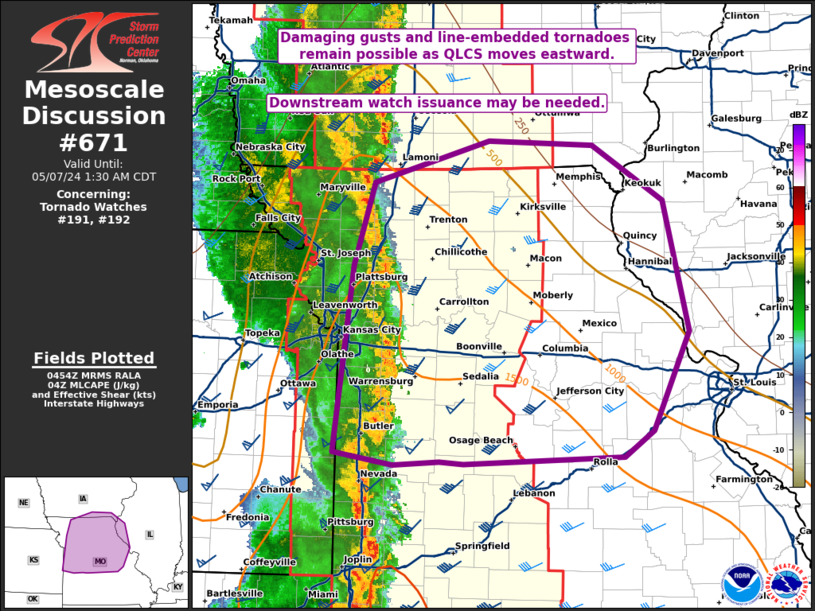
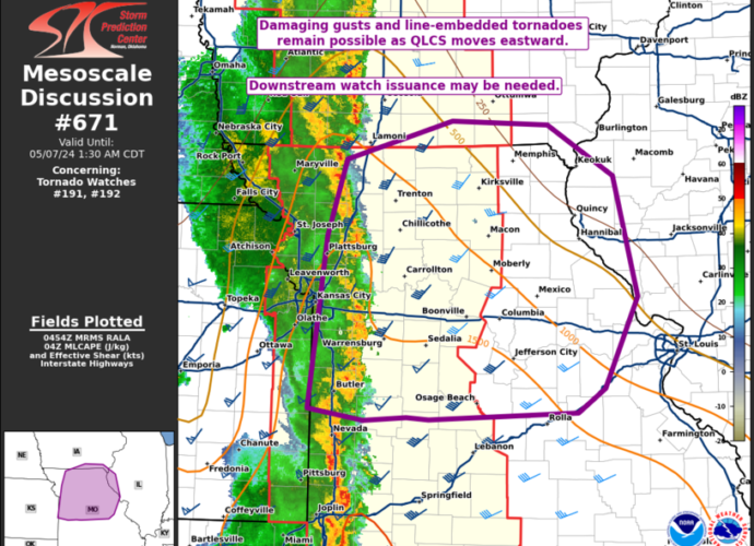
MD 0671 CONCERNING TORNADO WATCH 191…192… FOR CENTRAL IA INTO MO AND FAR WESTERN IL/SOUTHERN IA
Mesoscale Discussion 0671
NWS Storm Prediction Center Norman OK
1156 PM CDT Mon May 06 2024

Areas affected...Central IA into MO and far western IL/southern IA

Concerning...Tornado Watch 191...192...

Valid 070456Z - 070630Z

The severe weather threat for Tornado Watch 191, 192 continues.

SUMMARY...Damaging wind and perhaps a couple line-embedded tornadoes
remain possible overnight as an extensive QLCS moves eastward.
Downstream watch issuance may eventually be needed.

DISCUSSION...An extensive QLCS has recently moved through areas
near/south of Kansas City, with multiple mesovortices recently noted
along the leading edge of the line. Downstream, the environment
remains favorably unstable into central MO, with somewhat cooler and
more stable conditions noted into northeast MO, though some recovery
remains possible into this area prior to storm arrival.

Low-level shear/SRH remains strong according to regional VWPs, and a
threat for line-embedded tornadoes and damaging gusts will continue
eastward through the early overnight hours. Some threat is likely to
eventually move eastward out of WW 192, and downstream watch
issuance into parts of central/eastern MO may eventually be needed.

..Dean/Guyer.. 05/07/2024

...Please see www.spc.noaa.gov for graphic product...

ATTN...WFO...ILX...LSX...DVN...SGF...DMX...EAX...

LAT...LON   38089464 39739444 40469421 40829290 40799173 40299093
            39159064 38279105 38059139 37999319 38019346 37989397
            38089464
https://www.spc.noaa.gov/products/md/md0671.htmlSPC Mesoscale Discussions
SPC MD 670
2024-05-07
SPC Mesoscale Discussions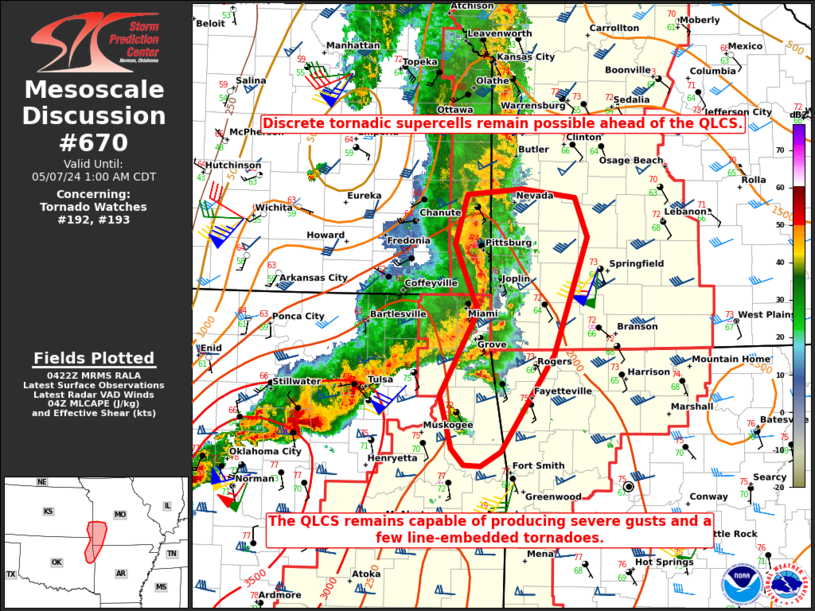
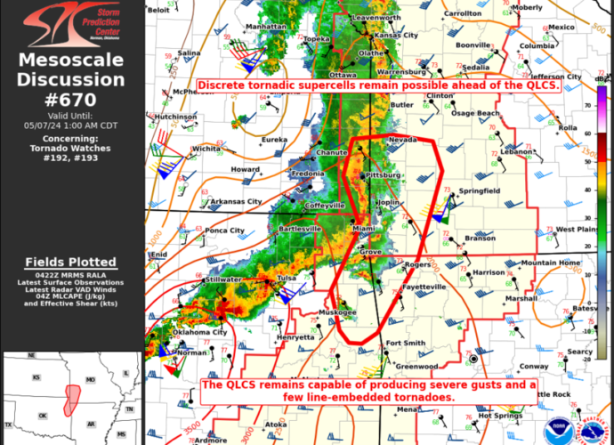
MD 0670 CONCERNING TORNADO WATCH 192…193… FOR EASTERN OK INTO EXTREME SOUTHEAST KS…SOUTHWEST MO…FAR NORTHWEST AR
Mesoscale Discussion 0670
NWS Storm Prediction Center Norman OK
1125 PM CDT Mon May 06 2024

Areas affected...Eastern OK into extreme southeast KS...southwest
MO...far northwest AR

Concerning...Tornado Watch 192...193...

Valid 070425Z - 070600Z

The severe weather threat for Tornado Watch 192, 193 continues.

SUMMARY...Tornadic supercells remain possible ahead of an expanding
QLCS. The QLCS will remain capable of producing severe gusts and
perhaps a few line-embedded tornadoes.

DISCUSSION...Renewed storm development has been noted over the last
hour across eastern OK, to the east and south of an expanding QLCS
approaching southwest MO. Regional VWPs continue to depict a very
favorable wind profile for tornadic supercells, within a moderate to
strongly unstable environment. Any discrete supercells that can
become established ahead of the line will pose a strong tornado
threat into the early overnight hours. Otherwise, the QLCS will
continue to move eastward into southwest MO with a threat for severe
gusts. Line-embedded tornadoes also remain possible with the QLCS,
especially where it overtakes any discrete cells that develop in
advance of the line.

..Dean.. 05/07/2024

...Please see www.spc.noaa.gov for graphic product...

ATTN...WFO...SGF...TSA...

LAT...LON   35869512 36079519 36849476 37459501 37919488 37959426
            37889366 37519351 36449389 35579449 35439473 35459491
            35599506 35869512
https://www.spc.noaa.gov/products/md/md0670.htmlSPC Mesoscale Discussions
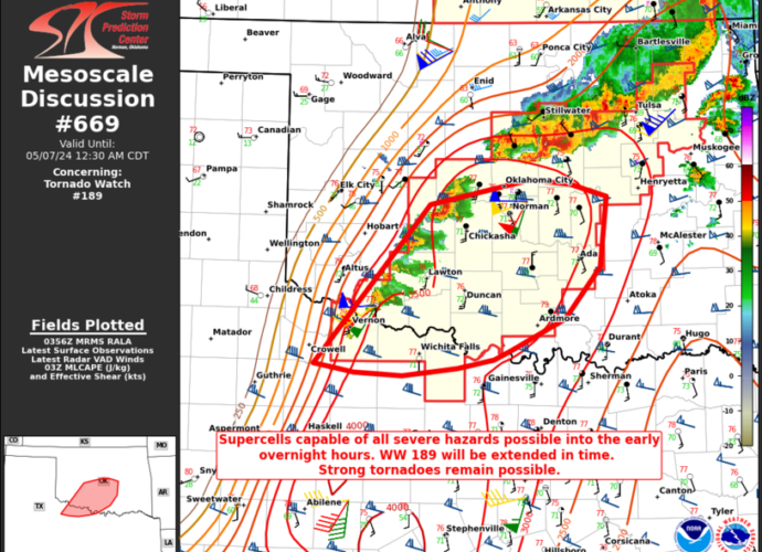
SPC MD 669
2024-05-07
SPC Mesoscale Discussions
MD 0669 CONCERNING TORNADO WATCH 189… FOR SOUTHWEST INTO CENTRAL OK…WESTERN NORTH TX
Mesoscale Discussion 0669
NWS Storm Prediction Center Norman OK
1059 PM CDT Mon May 06 2024

Areas affected...Southwest into central OK...western north TX

Concerning...Tornado Watch 189...

Valid 070359Z - 070530Z

The severe weather threat for Tornado Watch 189 continues.

SUMMARY...Supercells capable of all severe hazards will spread
eastward into the early overnight hours. Strong tornadoes remain
possible. WW 189 will be extended in time.

DISCUSSION...Storms have recently developed in the vicinity of the
Pacific cold front in southwest OK. Downstream, the 03Z OUN sounding
indicates a very favorable environment remains in place across
central OK, with strong buoyancy, effective shear of 60+ kt, and 0-1
km SRH of greater than 300 m2/s2. A threat for supercells will move
quickly eastward into the early overnight hours, with a threat of
all severe hazards. Strong to intense tornadoes remain possible if
discrete supercells can be maintained. WW 189 will be extended in
time to cover this threat.

..Dean.. 05/07/2024

...Please see www.spc.noaa.gov for graphic product...

ATTN...WFO...TSA...FWD...OUN...

LAT...LON   33819967 35299836 35539723 35489679 35379637 34709644
            34229684 33949745 33859764 33779806 33709868 33729922
            33789954 33819967
https://www.spc.noaa.gov/products/md/md0669.htmlSPC Mesoscale Discussions