
Overnight and Tomorrows forecast 6/ 25-26
Tonight – 50% Scattered T-storms, Low 68°F. Wind NW to SW 5 to 15 mph.
Tomorrow 6/26 – 80% Scattered T-storms, High 76°F. Wind SW 5-10 mph.
Tomorrow night – 60% Scattered T-storms. Low 58°F. Wind N 5-10 mph.

SPC Day 3-8 Fire Weather Outlook

Day 3-8 Fire Weather Outlook
NWS Storm Prediction Center Norman OK
0345 PM CDT Tue Jun 25 2024

Valid 271200Z - 031200Z

The potential for critical fire weather conditions will generally
remain low through the extended period, though at least low-end fire
concerns are anticipated later this week and over the upcoming
weekend. The upper ridge over the south-central CONUS is forecast to
gradually de-amplify through the end of the work week, allowing for
more amplified upper waves to propagate across the northern CONUS.
This will introduce precipitation chances to much of the Pacific
Northwest and Great Basin where fuels have been relatively dry.
However, strong low-level winds associated with successive upper
waves may support dry/windy conditions across the northern Great
Basin wherever rainfall accumulations are minimal.

...D3/Thursday - Northeast NV to eastern ID....
An upper-level trough is noted in afternoon GOES imagery approaching
the Pacific Northwest coast. The primary trough axis (and associated
mid-level jet max) will likely be traversing northern ID/western MT
around peak heating on D3/Thu. Diurnal mixing should facilitate
downward mixing of the stronger flow to the surface, resulting in
areas of elevated, to perhaps critical, fire weather conditions.
Ensemble guidance continues to show the best potential for fire
concerns across northeast NV into the Snake River Plain of eastern
ID, though elevated to critical conditions may emerge across
southern NV into northwest AZ/southwest UT (though fuel status is
not as receptive as compared to locations further north/northwest).
One limiting factor to the fire potential is any rainfall that can
accumulate in the preceding 24 hours. This concern, along with a
steady, but fairly modest, signal for critical conditions precludes
higher risk probabilities.

...D5/Saturday into D6/Sunday - Great Basin...
Deterministic and ensemble solutions suggest an initially
low-amplitude perturbation will deepen as it migrates across the
Pacific Northwest over the upcoming weekend. A deepening surface low
across the Great Basin on D5/Saturday will likely induce breezy
southerly winds across southern to central NV and western UT. Dry
air advecting northward from the Mojave desert region should support
areas of dry/windy conditions. Stronger winds are anticipated on
Sunday ahead of an approaching cold front. Dry/windy conditions
should overspread much of eastern NV/western UT into southwest WY.
Although spread is noted among deterministic solutions, ensemble
guidance suggests D6/Sun will see the highest potential for critical
fire weather conditions, warranting 40% risk probabilities. While
fuels are currently drying across this region, rain chances in the
coming days may mitigate the overall fire threat.

..Moore.. 06/25/2024

...Please see www.spc.noaa.gov/fire for graphic product...
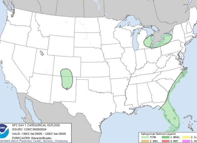
SPC Jun 25, 2024 2000 UTC Day 1 Convective Outlook
Day 1 Convective Outlook
NWS Storm Prediction Center Norman OK
0239 PM CDT Tue Jun 25 2024

Valid 252000Z - 261200Z

...THERE IS A SLIGHT RISK OF SEVERE THUNDERSTORMS FROM THE CENTRAL
PLAINS TO THE MID-MISSISSIPPI AND OHIO VALLEYS...

...SUMMARY...
Damaging wind gusts and large hail are possible across parts of the
central/southern Great Plains and Midwest into this evening.

...20z Update...

The ongoing outlook remains on track. Only  minor adjustments were
made to the Marginal (level 1 of 5) risk in South Dakota to account
for current trends where convection is developing. Other changes
were made to the 10 percent general thunderstorm line based on
latest observations and trends. For more details, refer to previous
outlook discussion below. For short term severe potential across
portions of SD reference MCD 1410.

..Leitman.. 06/25/2024

.PREV DISCUSSION... /ISSUED 1125 AM CDT Tue Jun 25 2024/

...OH Valley...
A large but weakening MCS is spreading southeastward across parts of
OH/IN/IL, with a broken line of strong cells along the leading line.
 The western flank of this activity over IL may intensify by mid
afternoon, spreading into parts of eastern MO and southern IL/IN,
posing a risk of damaging wind gusts and hail.

...IA/MO/NE...
Farther west, a hot, humid air mass is present today across much of
MO, southern IA, and eastern NE.  Widely scattered intense
thunderstorms are expected to form later this afternoon - mainly
along a boundary from southern IA into eastern NE.  These storms
would be in a sufficiently sheared environment for supercell
structures capable of very large hail and damaging winds.  Storms
are expected to sag southward through the evening.  Models differ on
evolution of storms overnight, with some solutions suggesting a
larger MCS building into southern MO by the end of the period.

...SD/NE...
An axis of southeasterly low-level winds and dewpoints in the mid
60s to 70s extends from the Black Hills region into southeast SD and
central NE.  Strong heating in this area will result in ample CAPE,
leading to scattered afternoon and evening storms.  Steep mid-level
lapse rates and moderately strong west-northwest flow aloft will
promote supercells capable of very large hail, damaging winds, and
perhaps a tornado.
Small Craft Advisory issued June 25 at 4:01PM EDT until June 25 at 10:00PM EDT by NWS Cleveland OH
LEZ144 The Islands to Vermilion OH* WHAT…Southwest winds 15 to 25 knots and waves 1 to 3 feet.
* WHERE…The nearshore waters of Lake Erie from Maumee Bay to
Willowick OH.
* WHEN…Until 10 PM EDT this evening.
* IMPACTS…Conditions will be hazardous to small craft.https://api.weather.gov/alerts/urn:oid:2.49.0.1.840.0.a85c2448c2760bf70a7bb477b0c38a2c3fe672be.002.1.cap4:07 pmJune 25, 2024
Small Craft Advisory issued June 25 at 4:01PM EDT until June 25 at 10:00PM EDT by NWS Cleveland OH
LEZ143 Reno Beach to The Islands OH* WHAT…Southwest winds 15 to 25 knots and waves 1 to 3 feet.
* WHERE…The nearshore waters of Lake Erie from Maumee Bay to
Willowick OH.
* WHEN…Until 10 PM EDT this evening.
* IMPACTS…Conditions will be hazardous to small craft.https://api.weather.gov/alerts/urn:oid:2.49.0.1.840.0.a85c2448c2760bf70a7bb477b0c38a2c3fe672be.002.1.cap4:07 pmJune 25, 2024
Small Craft Advisory issued June 25 at 4:01PM EDT until June 25 at 10:00PM EDT by NWS Cleveland OH
LEZ142 Maumee Bay to Reno Beach OH* WHAT…Southwest winds 15 to 25 knots and waves 1 to 3 feet.
* WHERE…The nearshore waters of Lake Erie from Maumee Bay to
Willowick OH.
* WHEN…Until 10 PM EDT this evening.
* IMPACTS…Conditions will be hazardous to small craft.https://api.weather.gov/alerts/urn:oid:2.49.0.1.840.0.a85c2448c2760bf70a7bb477b0c38a2c3fe672be.002.1.cap4:06 pmJune 25, 2024

SPC Day 1 Fire Weather Outlook

Day 1 Fire Weather Outlook
NWS Storm Prediction Center Norman OK
1130 AM CDT Tue Jun 25 2024

Valid 251700Z - 261200Z

...NO CRITICAL AREAS...

...Central High Plains...
An Elevated risk area has been introduced for portions of southeast
WY into the NE Panhandle and far northern CO. As of 16 UTC, surface
observations are already reported 15-20% RH with winds increasing to
around 15 mph within a downslope flow regime. Winds are forecast to
increase through late afternoon in the wake of a dry frontal passage
with gusts upwards of 25-30 mph possible. Although parts of this
region have received rainfall over the past 24 hours, a 1000 acre
fire was reported yesterday (Monday) northwest of Torrington, WY,
indicating that fuels are receptive where rain did not fall.

...western Great Basin...
Shallow convective showers with occasional lightning flashes have
been noted this morning over central CA as a plume of 0.9+ inch
PWATs migrates into western NV. MRMS data show that precipitation
rates are approaching 0.1 in/hour, with an increase in rain rates
likely as convection deepens through the afternoon within the
relatively moist air mass. These trends support the previous
forecast of mostly wet thunderstorms, though a few dry lightning
strikes outside of the precipitation cores are possible. Given the
associated cloud cover, confidence in elevated fire weather
conditions across northwest NV into OR remains limited. See the
previous discussion for additional details.

..Moore.. 06/25/2024

.PREV DISCUSSION... /ISSUED 0131 AM CDT Tue Jun 25 2024/

...Synopsis...
An approaching mid to upper-level Pacific trough will begin to
promote breezy southwesterly surface winds across portions of far
northern CA and south-central OR later this afternoon. A small
Elevated area was considered across this region, where RH is
expected to drop into the low teens. However, given the isolated
nature of the expected elevated conditions, and overlap with less
receptive fuels, it was not included at this time.

Thunderstorms are still expected to develop this afternoon over the
Great Basin, within a mid-level plume of moisture lifting northward
out of southern CA. Initial thunderstorm development in and around
the Wassuk Range of NV, and White Mountains of NV/CA, may contain
dry lightning. A small area of Isolated Dry Thunderstorms was
considered here. However, increasing PWATS and scattered, wet
thunderstorms will soon follow. In addition, the dry lightning
strikes should remain west of the more volatile fuels found further
east/northeast of these ranges.

...Please see www.spc.noaa.gov/fire for graphic product...