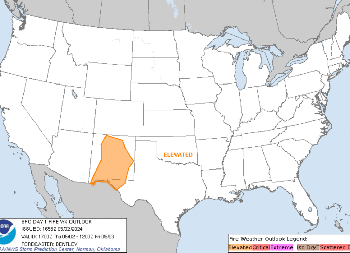
SPC Day 3-8 Fire Weather Outlook
2024-06-25

SPC Day 3-8 Fire Weather Outlook
Day 3-8 Fire Weather Outlook
NWS Storm Prediction Center Norman OK
0348 PM CDT Mon Jun 24 2024

Valid 261200Z - 021200Z

Confidence in critical fire weather conditions remains limited
through the second half of the work week and into the upcoming
weekend. However, at least low-end fire concerns are expected to
persist across parts of the Great Basin.

...D3/Wednesday to D4/Thursday - northern Great Basin...
Recent GOES water-vapor imagery reveals a upper low over the
northern Pacific that is gradually approaching the Pacific
Northwest. Concurrently, mid-level moisture is slowly streaming
northward through central/southern CA. A combination of increasing
moisture and ascent ahead of the wave should promote isolated to
scattered showers and thunderstorms across the Pacific Northwest and
parts of the Great Basin beginning early D3/Wed. Increasing
low-level winds within the dry slot of the maturing low will promote
dry/windy conditions in the lee of the northern Sierra Nevada.
Recent ensemble guidance continues to show a signal for elevated to
critical fire weather conditions across northwest NV and adjacent
portions of OR; however, the extent of the fire weather threat may
be conditional on morning rainfall amounts and sufficient clearing
in the wake of morning showers/thunderstorms.

The mid-level jet max is forecast to pass over the northern Great
Basin/northern Rockies around peak heating on D4/Thur. The westerly
downslope flow regime across much of NV and southern ID should
continue to promote dry conditions, especially across areas that
receive little rainfall in the preceding 24 hours. Ensemble
solutions show a strong signal for 15+ mph winds, and drier
solutions - notably the deterministic GFS as well as a few GEFS
members - suggest winds may reach 20-30 mph as strong mid-level flow
mixes to the surface. Consequently, elevated to critical fire
weather conditions appear possible.

...D6/Saturday to D7/Sunday - Great Basin...
Long-range ensembles and cluster analyses continue to suggest that a
second, perhaps more amplified, upper wave will approach the Pacific
Northwest/northern Great Basin during the D6/Sat to D7/Sun period.
While spread in guidance is noted (and expected at this range), the
overall synoptic regime implies increasing rain chances for the
Pacific Northwest with fire weather potential across central NV into
UT where drier/windier conditions are probable. Trends in this
system will be monitored for potential fire concerns heading into
the upcoming weekend.

..Moore.. 06/24/2024

...Please see www.spc.noaa.gov/fire for graphic product...
SPC Jun 25, 2024 0100 UTC Day 1 Convective Outlook
2024-06-25
SPC 0100Z Day 1 Outlook

Day 1 Convective Outlook
NWS Storm Prediction Center Norman OK
0758 PM CDT Mon Jun 24 2024

Valid 250100Z - 251200Z

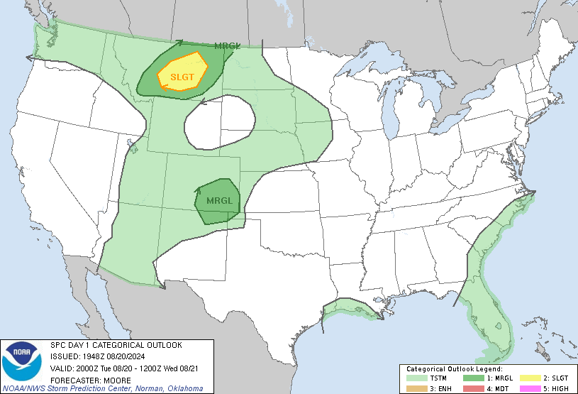
...THERE IS AN ENHANCED RISK OF SEVERE THUNDERSTORMS OVER PORTIONS
OF THE UPPER MISSISSIPPI RIVER VALLEY...

...SUMMARY...
Scattered severe thunderstorms are expected over parts of the Upper
Midwest this evening and overnight. A corridor of potentially
widespread destructive wind gusts could develop over parts of
Minnesota into Wisconsin.

...01z Update Upper Midwest...
Much of the previous forecast remains unchanged with only minor
modifications. Several areas of scattered thunderstorms are ongoing
over the northern Red River Valley and upper Midwest. Scattered
supercells ahead of the occluded front over northern MN should
continue eastward with a risk for damaging gusts and hail this
evening before slowly weakening as they encounter decreasing
buoyancy near Lake Superior.

Farther south, complexities surrounding the isolated ongoing
convection in southern WI and additional convective initiation of
elevated storms near and north of the effective warm front remain
substantial. Storms over southern WI appear likely to continue
southeast on the fringes of the better ascent and buoyancy with a
risk for damaging gusts and hail this evening. Observational data
shows increasing low-level warm-air advection and upper-level ascent
could support additional storm development this evening over
portions of west-central MN with the potential for rapid upscale
growth into a bowing MCS. Substantial spatial uncertainty is also
evident in late afternoon CAM guidance, but most guidance now does
indicate some form of relatively intense MCS forming along the front
in the 02-04z time frame. With 5000-6000 J/kg MUCAPE and moderate
effective shear in place, a swath of significant damaging winds
remains possible over parts of eastern MN, and much of
central/southern WI, though with substantial uncertainty. Will
maintain level-3 Enhanced wind probabilities as is with minor
adjustments to the level-2 Slight over lower MI where storms may
persist through the end of the convective period.

...Carolinas...
The cold front over the eastern US is slowly moving offshore this
evening. Remaining storms have undergone a gradual decrease in
coverage and intensity this evening with the cessation of diurnal
heating and the weakening of broader-scale forcing for ascent. An
isolated damaging gust could occur with the stronger storms centered
near the NC/SC border, but the broader severe risk should continue
to decrease below MRGL criteria after sunset.

..Lyons.. 06/25/2024
SPC Day 3-8 Fire Weather Outlook
2024-06-24

SPC Day 3-8 Fire Weather Outlook
Day 3-8 Fire Weather Outlook
NWS Storm Prediction Center Norman OK
0348 PM CDT Mon Jun 24 2024

Valid 261200Z - 021200Z

Confidence in critical fire weather conditions remains limited
through the second half of the work week and into the upcoming
weekend. However, at least low-end fire concerns are expected to
persist across parts of the Great Basin.

...D3/Wednesday to D4/Thursday - northern Great Basin...
Recent GOES water-vapor imagery reveals a upper low over the
northern Pacific that is gradually approaching the Pacific
Northwest. Concurrently, mid-level moisture is slowly streaming
northward through central/southern CA. A combination of increasing
moisture and ascent ahead of the wave should promote isolated to
scattered showers and thunderstorms across the Pacific Northwest and
parts of the Great Basin beginning early D3/Wed. Increasing
low-level winds within the dry slot of the maturing low will promote
dry/windy conditions in the lee of the northern Sierra Nevada.
Recent ensemble guidance continues to show a signal for elevated to
critical fire weather conditions across northwest NV and adjacent
portions of OR; however, the extent of the fire weather threat may
be conditional on morning rainfall amounts and sufficient clearing
in the wake of morning showers/thunderstorms.

The mid-level jet max is forecast to pass over the northern Great
Basin/northern Rockies around peak heating on D4/Thur. The westerly
downslope flow regime across much of NV and southern ID should
continue to promote dry conditions, especially across areas that
receive little rainfall in the preceding 24 hours. Ensemble
solutions show a strong signal for 15+ mph winds, and drier
solutions - notably the deterministic GFS as well as a few GEFS
members - suggest winds may reach 20-30 mph as strong mid-level flow
mixes to the surface. Consequently, elevated to critical fire
weather conditions appear possible.

...D6/Saturday to D7/Sunday - Great Basin...
Long-range ensembles and cluster analyses continue to suggest that a
second, perhaps more amplified, upper wave will approach the Pacific
Northwest/northern Great Basin during the D6/Sat to D7/Sun period.
While spread in guidance is noted (and expected at this range), the
overall synoptic regime implies increasing rain chances for the
Pacific Northwest with fire weather potential across central NV into
UT where drier/windier conditions are probable. Trends in this
system will be monitored for potential fire concerns heading into
the upcoming weekend.

..Moore.. 06/24/2024

...Please see www.spc.noaa.gov/fire for graphic product...
SPC Jun 24, 2024 2000 UTC Day 1 Convective Outlook
2024-06-24
SPC 2000Z Day 1 Outlook

Day 1 Convective Outlook
NWS Storm Prediction Center Norman OK
0300 PM CDT Mon Jun 24 2024

Valid 242000Z - 251200Z

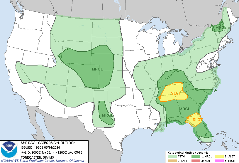
...THERE IS AN ENHANCED RISK OF SEVERE THUNDERSTORMS IN THE UPPER MS
VALLEY ACROSS SOUTH WI...

...THERE IS A SLIGHT RISK OF SEVERE THUNDERSTORMS SEPARATELY IN EAST
NC...

...SUMMARY...
Scattered severe thunderstorms are expected over parts of the Upper
Midwest late this afternoon into tonight. A corridor of potentially
widespread destructive wind gusts could develop over parts of
Minnesota into Wisconsin.

...20Z Update...
Overall forecast scenario remains valid with potential for an
intense, bowing MCS this evening into tonight. With continued
spatiotemporal differences among recent guidance for initial
supercell development, confidence is below-average for further
increases in severe probabilities along the north-northwest to
south-southeast oriented MLCAPE gradient over the Upper MS Valley.
In addition, the likely orientation of the MCS with respect to the
instability gradient suggest the significant severe wind threat may
be relatively confined owing to abundant warm-moist sector MLCIN to
the west and diminishing instability to the east. The corridor
previously highlighted, that is centered on a portion of the Upper
MS Valley into south WI, remains the most probable zone for
potentially destructive wind gusts.

..Grams.. 06/24/2024

.PREV DISCUSSION... /ISSUED 1131 AM CDT Mon Jun 24 2024/

...Upper Midwest...
A weakening MCS continues to track eastward across central MN,
associated with a shortwave trough over southern Canada.  Extreme
instability will develop along the southern fringe of this MCS and
accompanying cloud shield, with hot/humid conditions leading to
MLCAPE values over 4500 J/kg by late afternoon across southwest MN.
Very warm temperatures aloft will likely suppress convective
development in this volatile air mass, but strengthening
southwesterly low-level winds by early evening will enhance warm
advection and likely lead to thunderstorms over central MN.  Initial
storms will be supercellular, with forecast soundings showing ample
low level and deep-layer shear to support a risk of very large hail,
damaging winds, and a few tornadoes.

As the evening progresses, most morning CAM solutions indicate that
the cluster of supercells will grow upscale into a fast moving
bowing MCS.  However, there is considerable diversity regarding the
track of the most intense storms.  Given the very warm temperatures
aloft, it seems likely the storms will track southeastward along the
thermal gradient - across central/southern WI and into northern IL.
The potential exists for a corridor of widespread and occasionally
significant (exceeding 65 kt) wind damage, so have upgraded to ENH.
The low-level air mass will become increasingly less unstable as the
storms move across Lake Michigan and into northern IN by early Tue
morning, suggesting a weakening trend.

...Central High Plains...
Scattered high-based showers and thunderstorms are expected to
develop over the central Rockies and Black Hills today and spread
eastward into parts of SD/NE/KS.  Hot surface temperatures and
inverted-v profiles will support a risk of gusty/damaging winds with
this activity for a few hours early this evening.

...Eastern NC/SC...
A surface front is sagging southeastward across NC today, with a
very moist and moderately unstable air mass in place ahead of the
front.  Thunderstorms are expected to form in this environment, with
sufficient westerly flow aloft to help organize the storms and
promote a risk of damaging wind gusts.  Given the amount of heating
that is occurring in eastern NC, and morning guidance showing
substantial coverage of storms, have added a SLGT risk for parts of
this area.
SPC Day 1 Fire Weather Outlook
2024-06-24
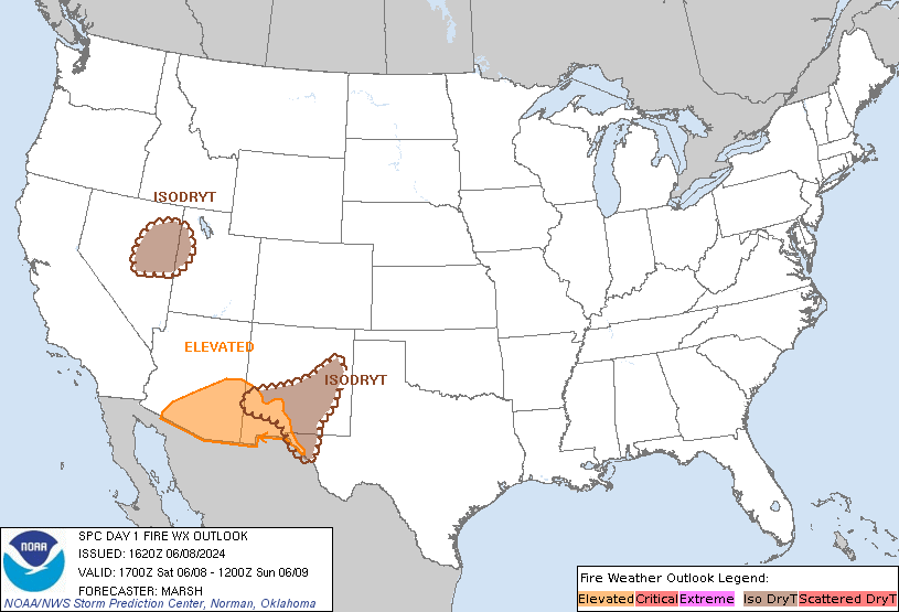
SPC Day 1 Fire Weather Outlook
Day 1 Fire Weather Outlook
NWS Storm Prediction Center Norman OK
1041 AM CDT Mon Jun 24 2024

Valid 241700Z - 251200Z

The previous forecast remains on track with only minor adjustments
needed. Latest surface observations are in line with morning model
solutions, which depict dry conditions but slightly weaker winds
compared to yesterday (which yielded predominantly elevated fire
weather conditions). See the previous discussion below for
additional details.

..Moore.. 06/24/2024

.PREV DISCUSSION... /ISSUED 0135 AM CDT Mon Jun 24 2024/

...Synopsis...
An upper-level trough will continue eastward into the Northern
Plains today. Upper-level winds across the Northwest into the
northern Great Basin will remain modestly strong into the afternoon.
Similarly, a modestly strong surface pressure gradient will remain
across these areas before weakening overnight.

...OR/CA/NV into Snake River Plain...
Though surface winds will be slightly weaker than on Sunday, 15-20
mph winds can generally be expected given the lingering presence of
the synoptic features described earlier. Stronger winds do appear
probable in the Snake River Plain due to terrain effects and
favorable orientation of the mid-level winds. RH of 15-20% will be
common by the afternoon. Elevated fire weather is expected with the
greatest potential for locally critical conditions in the Snake
River Plain.

...Please see www.spc.noaa.gov/fire for graphic product...
SPC Day 2 Fire Weather Outlook
2024-06-24
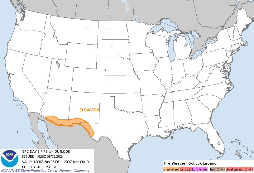
SPC Day 2 Fire Weather Outlook
Day 2 Fire Weather Outlook
NWS Storm Prediction Center Norman OK
0218 PM CDT Mon Jun 24 2024

Valid 251200Z - 261200Z

...NO CRITICAL AREAS...

The previous forecast remains on track. Recent high-res ensemble
guidance continues to suggest the potential for elevated fire
weather conditions across northwest NV into southern/southeast OR;
however, increasing mid/high-level cloud cover should modulate
diurnal RH reductions across this region. Thunderstorm development
remains probable across the western to central Great Basin late
Tuesday into early Wednesday as a plume of 1.0+ inch PWAT values
(already noted in GOES imagery over southern CA) migrates northward
ahead of an approaching mid-level wave. While some dilution of this
moisture is expected over the next 24 hours, model solutions and
forecast soundings suggest that most thunderstorms should produce
wetting rainfall. Consequently, confidence in the dry lightning
threat remains limited.

..Moore.. 06/24/2024

.PREV DISCUSSION... /ISSUED 0137 AM CDT Mon Jun 24 2024/

...Synopsis...
An upper-level ridge will build into the Great Basin and extend into
the Northwest on Tuesday. Overall, mid-level winds will be weaker
across these areas than on previous days. There is some potential
for subtle shortwave troughs within the flow to enhance winds in
parts of northwest Nevada and southeast Oregon. An upper-level
trough will approach the Northwest late in the period. The surface
pressure pattern will be rather nebulous for much of the day. A
surface low will deepen within the Columbia Basin vicinity, but this
will primarily occur during the evening/overnight. At this time,
only locally elevated fire weather conditions are expected from
parts of northern Nevada into southeast Oregon and southern Idaho.

A plume of mid-level moisture will push farther north and west as
well. A weak shortwave trough is expected to promote thunderstorms
along the Sierra Front in Nevada. The areas where confidence in
storm coverage is highest will see an increase in PWAT values to
near/over an inch. Drier storms could occur farther east in an area
where mid-level moisture is less, but confidence in coverage is also
much lower.

...Please see www.spc.noaa.gov/fire for graphic product...


