Sticky
Overnight and Tomorrows forecast 5- 3/4
2024-05-03
Tonight – Patchy fog, 60% Showers and T-storms. Low 59°F. Wind E, 5 to 10 mph.
Tomorrow 5-4 – Patchy fog, 60% Showers and T-storms, High 73°F. Wind SE, 5 to 10 mph.
Tomorrow night – 60% Showers and T-storms, Low 61°F. Wind SE, 5 to 10 mph.


SPC MD 627
2024-05-04
SPC Mesoscale Discussions
MD 0627 CONCERNING SEVERE THUNDERSTORM WATCH 182… FOR SOUTHEAST NEBRASKA…SOUTHWEST IOWA…NORTHWESTERN MISSOURI…NORTHEAST KANSAS
Mesoscale Discussion 0627
NWS Storm Prediction Center Norman OK
0102 AM CDT Sat May 04 2024

Areas affected...Southeast Nebraska...Southwest Iowa...Northwestern
Missouri...Northeast Kansas

Concerning...Severe Thunderstorm Watch 182...

Valid 040602Z - 040800Z

The severe weather threat for Severe Thunderstorm Watch 182
continues.

SUMMARY...A wind-damage threat is expected to continue across parts
of the lower to mid Missouri Valley tonight. A watch extension in
area has been made for Cowley and Butler Counties in Kansas.
However, the line is expected to become increasingly marginal over
time, and new weather watch issuance is not expected to the east of
WW 182.

DISCUSSION...The latest hi-resolution radar from Hastings shows a
large-scale bowing line segment across southeast Nebraska and
north-central Kansas. This line of storms is located near a warm
front, which extends east-southeastward into northern Missouri. From
near and to the south of the front, surface dewpoints are in upper
50s and lower 60s F, with MLCAPE is in the 1000 to 1500 J/kg range.
In addition, a shortwave trough is evident on water vapor imagery
over central Kansas. Large-scale ascent associated with the
shortwave and the instability will provide support for the ongoing
linear MCS for a few more hours. Isolated damaging gusts will be
possible along the leading edge of the MCS. However, as MLCIN
strengthens across the central Plains and instability decreases, the
wind-damage threat is expected to become more marginal with time.

..Broyles.. 05/04/2024

...Please see www.spc.noaa.gov for graphic product...

ATTN...WFO...DMX...EAX...OAX...TOP...ICT...GID...

LAT...LON   39459466 39969433 40309425 40469436 40599469 40689618
            40659680 40279733 39659798 39389816 39129808 39039744
            39019585 39199505 39459466
https://www.spc.noaa.gov/products/md/md0627.htmlSPC Mesoscale Discussions

Overcast and 66 F at Dayton / Wright-Patterson Air Force Base, OH
2024-05-04

Winds are Northeast at 4.6 MPH (4 KT). The pressure is 1015.5 mb and the humidity is 92%.
Last Updated on May 4 2024, 12:55 am EDT.
Winds are Northeast at 4.6 MPH (4 KT). The pressure is 1015.5 mb and the humidity is 92%.
Last Updated on May 4 2024, 12:55 am EDT.
Last Updated on May 4 2024, 12:55 am EDT.

SPC Day 3-8 Fire Weather Outlook
2024-05-04
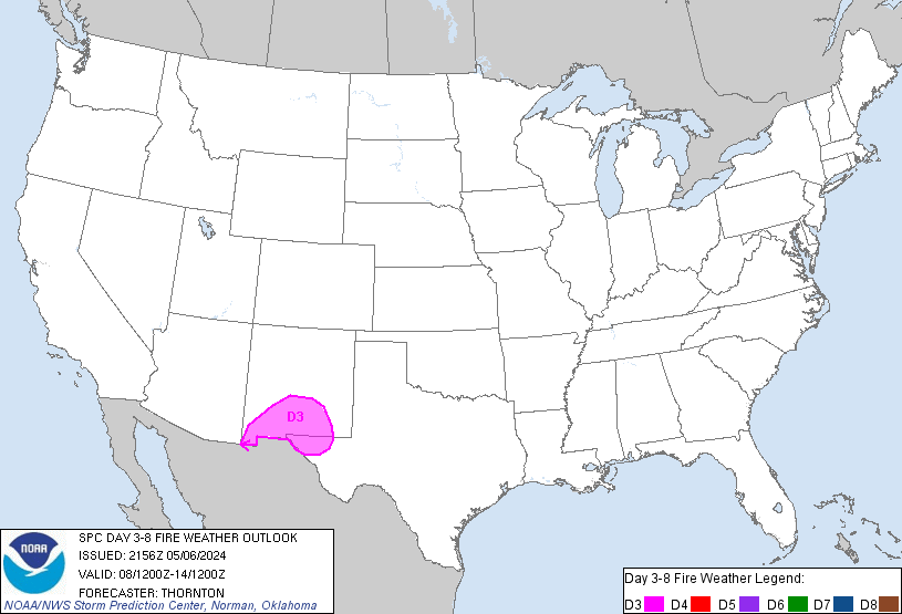
SPC Day 3-8 Fire Weather Outlook
Day 3-8 Fire Weather Outlook
NWS Storm Prediction Center Norman OK
0401 PM CDT Fri May 03 2024

Valid 051200Z - 111200Z

An active period of fire weather concerns remains likely beginning
late this weekend and lasting well into the upcoming work week. The
greatest fire weather risk will be focused across the central to
southern Rockies and into adjacent areas of the central/southern
High Plains where a dry air mass is already in place. Latest
ensemble guidance continues to show strong agreement in the
evolution of an upper-level trough (currently noted in water-vapor
imagery over the northeast Pacific) as it translates east across the
inter-mountain West and into the Plains Sunday and Monday, reaching
the Great Lakes/northern Plains by Tuesday/Wednesday. Strong low to
mid-level flow associated with this system will support multiple
days of dry, windy conditions with an accompanying fire weather
risk.

...D3/Sunday to D6/Wednesday - New Mexico and adjacent portions of
TX/CO...
Strong divergence aloft ahead of the approaching upper-level wave
will support broad surface pressure falls across the central Rockies
on Sunday afternoon. In response, southerly winds will increase
across much of the Four Corners region into central and eastern NM.
Latest mid-range ensemble guidance suggests sustained 20-25 mph
winds will be common by late afternoon when RH values should be
reaching their diurnal minimums between 10-20%. Although fuels
across western NM are not overly dry as of Friday afternoon,
dry/windy conditions on Saturday across this region should help cure
finer fuels by Sunday.

Perhaps the most intense fire weather conditions are anticipated on
Monday afternoon across portions of east/northeast NM. The ejection
of the surface low into the Plains Monday afternoon will support
strong westerly downslope winds off the central/southern Rockies.
This will maintain dry conditions across the region with 10-20% RH
common. Elevated conditions are expected across a broad swath of the
High Plains with critical conditions likely across much of eastern
NM. Latest forecast guidance hints that 25-30 mph sustained winds
are probable across northeast NM in the lee of the Sangre de Cristo
Mountains. While this portion of northeast NM is currently receiving
rainfall, such dry/windy conditions should yield dried grasses after
a few hours.

Persistent zonal flow will linger over the southern Rockies
D5/Tuesday into D6/Wednesday. This will maintain a downslope flow
regime with an attendant dry air mass (afternoon minimum RH values
in the teens) across the southern High Plains with potential both
days for elevated to critical fire weather conditions. The critical
risk areas have been adjusted in this outlook update to reflect
where medium to long-range ensemble guidance shows the strongest
signal for sustained 20+ mph winds. These areas will likely be
refined in subsequent outlooks as mesoscale details come into focus.
Elevated conditions may linger into D7/Thursday across southern NM,
but weakening gradient winds aloft should limit fire weather
potential compared to previous days.

..Moore.. 05/03/2024

...Please see www.spc.noaa.gov/fire for graphic product...

SPC MD 626
2024-05-04
SPC Mesoscale Discussions
MD 0626 CONCERNING SEVERE THUNDERSTORM WATCH 182… FOR SOUTH-CENTRAL KANSAS INTO THE NORTHWESTERN QUARTER OF OKLAHOMA
Mesoscale Discussion 0626
NWS Storm Prediction Center Norman OK
1141 PM CDT Fri May 03 2024

Areas affected...south-central Kansas into the northwestern quarter
of Oklahoma

Concerning...Severe Thunderstorm Watch 182...

Valid 040441Z - 040615Z

The severe weather threat for Severe Thunderstorm Watch 182
continues.

SUMMARY...Risk for locally damaging wind gusts continues across
portions of south-central Kansas and adjacent northwestern Oklahoma.

DISCUSSION...Latest radar loop shows bands/clusters of organized
storms moving eastward across the southern half of WW 182.  Ample
instability exists ahead of the convection, given the degree of
organization, to support continuation of the storms over the next
couple of hours -- particularly given ascent associated with warm
advection as a result of the observed 50 kt low-level jet.  While
mid-level flow remains rather weak across the area, storms continue
to advance steadily eastward in tandem with rather well-defined
outflow, and will be accompanied by at least local risk for wind
gusts near or slightly exceeding severe levels.

..Goss.. 05/04/2024

...Please see www.spc.noaa.gov for graphic product...

ATTN...WFO...ICT...OUN...DDC...

LAT...LON   35529989 36129911 36569921 36749910 36969929 37449863
            37669861 37459823 36679773 35879790 35429802 35529989
https://www.spc.noaa.gov/products/md/md0626.htmlSPC Mesoscale Discussions

SPC MD 625
2024-05-04
SPC Mesoscale Discussions
MD 0625 CONCERNING SEVERE THUNDERSTORM WATCH 181…182… FOR PARTS OF SOUTHERN NEBRASKA AND ADJACENT NORTH-CENTRAL KANSAS
Mesoscale Discussion 0625
NWS Storm Prediction Center Norman OK
1101 PM CDT Fri May 03 2024

Areas affected...parts of southern Nebraska and adjacent
north-central Kansas

Concerning...Severe Thunderstorm Watch 181...182...

Valid 040401Z - 040500Z

The severe weather threat for Severe Thunderstorm Watch 181, 182
continues.

SUMMARY...A bowing band of severe storms -- capable of producing
damaging wind gusts and possibly a brief tornado -- will continue
moving eastward near and just north of the Nebraska/Kansas border.

DISCUSSION...Latest radar loop shows a bowing band of strong/severe
storms crossing south-central Nebraska at this time.  The convection
is situated just east of a weak frontal wave, and riding along the
surface warm front.  With weaker instability with eastward extent,
storms may diminish somewhat over the next 1 to 2 hours, though a
slight east-southeastward turn -- along the instability gradient --
is also anticipated.  Damaging wind gusts will be possible over the
next 1 to 2 hours, along with potential for a brief tornado.

..Goss.. 05/04/2024

...Please see www.spc.noaa.gov for graphic product...

ATTN...WFO...OAX...TOP...GID...

LAT...LON   39919865 40289850 40719867 40679791 40679751 40209710
            39799741 39919865
https://www.spc.noaa.gov/products/md/md0625.htmlSPC Mesoscale Discussions

SPC May 4, 2024 0100 UTC Day 1 Convective Outlook
2024-05-04
SPC 0100Z Day 1 Outlook
Day 1 Convective Outlook
NWS Storm Prediction Center Norman OK
0752 PM CDT Fri May 03 2024

Valid 040100Z - 041200Z

...THERE IS A SLIGHT RISK OF SEVERE THUNDERSTORMS ACROSS PORTIONS OF
THE CENTRAL AND SOUTHERN PLAINS...

...SUMMARY...
Scattered severe thunderstorms are expected across portions of the
central and southern Plains. Large hail and damaging winds are the
primary risks.

...01z Outlook...

Cool mid-level profiles, and steep lapse rates contributed to the
evolution of supercell clusters over much of northwest TX into the
Edwards Plateau region. This activity is beginning to overturn much
of the buoyancy across northwest TX, hence the strongest updrafts
are now propagating southeast across the Edwards Plateau along an
instability axis characterized by MLCAPE on the order of 3000 J/kg.
Additionally, strong convection has developed just west of the
international border and is approaching Eagle Pass. Will adjust
severe probabilities into the middle Rio Grande Valley to account
for this activity spreading east of the River.

Farther north, organized band of thunderstorms has developed along a
cold front that is surging southeast across south-central
NE-northwest KS-northeast CO. In addition to a few dryline
supercells over western KS, this complex will continue to propagate
southeast aided in large part to the surging cold front. Given the
organization of this activity, and momentum, will extend higher
severe probs a bit downstream to account for wind/hail threat with
this squall line.

..Darrow.. 05/04/2024