
SPC Fire Weather Outlooks
SPC Day 2 Fire Weather Outlook
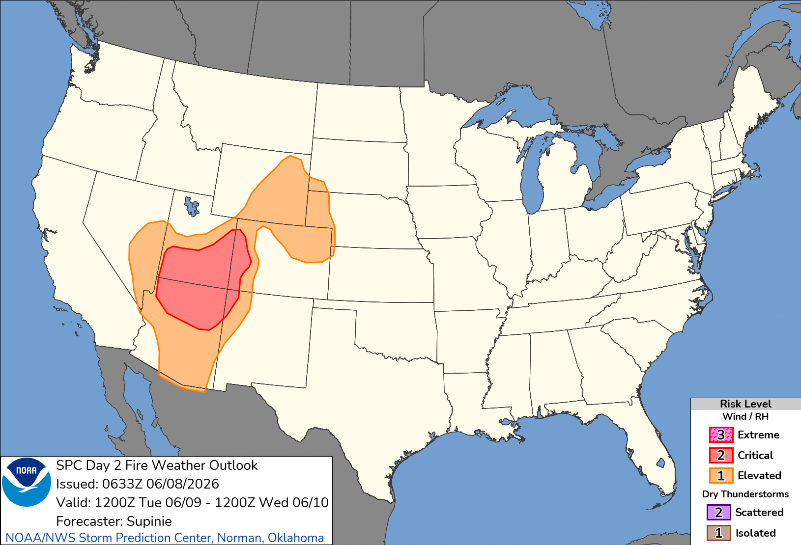
Day 2 Fire Weather Outlook
NWS Storm Prediction Center Norman OK
0133 AM CDT Mon Jun 08 2026

Valid 091200Z - 101200Z

...CRITICAL FIRE WEATHER AREA FOR PORTIONS OF THE SOUTHWEST AND
GREAT BASIN...

...Synopsis...
A longwave trough will remain in place over the northwestern CONUS
through the day on Tuesday with a strong jet max moving in across
portions of the Pacific Northwest and Great Basin. This will result
gusty winds across portions of the Southwest, Great Basin, and
central Rockies, and central High Plains.

...Southwest and Great Basin...
Diurnal mixing with strong (for the season) flow aloft will result
in winds of 20-30 mph across much of the region along with RH of
5-15% in the afternoon. Continued poor overnight RH recovery means
fuels in this area are critically dry. Therefore, have introduced a
Critical fire weather risk area here.

...Central High Plains and Foothills...
Strong winds (20-30 mph and locally higher) are expected to
overspread the region along with RH values in the 10-15% range west
of a dryline. The primary uncertainty in this region is with the
fuels, as many areas have received precipitation recently, and some
may receive additional precipitation on Monday. Therefore, will add
an Elevated risk in this area, though there may be some localized
areas of Critical fire weather risk.

..Supinie.. 06/08/2026

...Please see www.spc.noaa.gov/fire for graphic product...
SPC Day 2 Fire Weather Outlook
Day 2 Fire Weather Outlook
NWS Storm Prediction Center Norman OK
0133 AM CDT Mon Jun 08 2026

Valid 091200Z - 101200Z

...CRITICAL FIRE WEATHER AREA FOR PORTIONS OF THE SOUTHWEST AND
GREAT BASIN...

...Synopsis...
A longwave trough will remain in place over the northwestern CONUS
through the day on Tuesday with a strong jet max moving in across
portions of the Pacific Northwest and Great Basin. This will result
gusty winds across portions of the Southwest, Great Basin, and
central Rockies, and central High Plains.

...Southwest and Great Basin...
Diurnal mixing with strong (for the season) flow aloft will result
in winds of 20-30 mph across much of the region along with RH of
5-15% in the afternoon. Continued poor overnight RH recovery means
fuels in this area are critically dry. Therefore, have introduced a
Critical fire weather risk area here.

...Central High Plains and Foothills...
Strong winds (20-30 mph and locally higher) are expected to
overspread the region along with RH values in the 10-15% range west
of a dryline. The primary uncertainty in this region is with the
fuels, as many areas have received precipitation recently, and some
may receive additional precipitation on Monday. Therefore, will add
an Elevated risk in this area, though there may be some localized
areas of Critical fire weather risk.

..Supinie.. 06/08/2026

...Please see www.spc.noaa.gov/fire for graphic product...
11:45 AMJune 8, 2026
