SPC Fire Weather Outlooks
SPC Day 1 Fire Weather Outlook
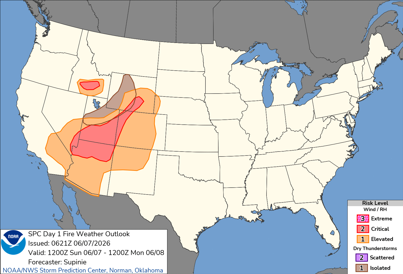
Day 1 Fire Weather Outlook
NWS Storm Prediction Center Norman OK
0121 AM CDT Sun Jun 07 2026

Valid 071200Z - 081200Z

...CRITICAL FIRE WEATHER AREA FOR PORTIONS OF THE SOUTHWEST...GREAT
BASIN...CENTRAL ROCKIES...
...CRITICAL FIRE WEATHER AREA FOR PORTIONS OF SOUTHERN IDAHO...

...Synopsis...
A longwave mid-level trough will remain situated over the
northwestern CONUS through the day on Sunday, with a shortwave
trough moving across the northern Rockies. The attendant surface low
and cold front will result in breezy conditions across portions of
the Great Basin, southwestern CONUS, and northern Rockies with low
RH values and critically dry fuels.

...Southwest, Great Basin, and Central Rockies...

Ahead of the cold front, strong vertical mixing and a tight pressure
gradient will result in gusty winds to 25-35 mph along with 5-15%
RH. Poor overnight RH recovery across much of the area is expected
to contribute to critically dry fuels across the region. For these
reasons, a Critical area has been maintained in this outlook.
Additionally, the cold front may provide enough lift and mid-level
moisture for thunderstorm development across portions of Utah to
central Wyoming. Given low precipitable water values and relatively
fast storm motions, some Isolated Dry Thunder may occur in this
region.

...Snake River Plain...

Beneath the departing mid-level jet max, a relatively localized area
of Critical conditions is expected in the Snake River Plain in Idaho
colocated. Here, strong vertical mixing will result in winds of
25-35 mph along with 10-15% RH. Dry fuels in this region mean that a
Critical area is warranted.

..Supinie.. 06/07/2026

...Please see www.spc.noaa.gov/fire for graphic product...
SPC Day 1 Fire Weather Outlook
Day 1 Fire Weather Outlook
NWS Storm Prediction Center Norman OK
0121 AM CDT Sun Jun 07 2026

Valid 071200Z - 081200Z

...CRITICAL FIRE WEATHER AREA FOR PORTIONS OF THE SOUTHWEST...GREAT
BASIN...CENTRAL ROCKIES...
...CRITICAL FIRE WEATHER AREA FOR PORTIONS OF SOUTHERN IDAHO...

...Synopsis...
A longwave mid-level trough will remain situated over the
northwestern CONUS through the day on Sunday, with a shortwave
trough moving across the northern Rockies. The attendant surface low
and cold front will result in breezy conditions across portions of
the Great Basin, southwestern CONUS, and northern Rockies with low
RH values and critically dry fuels.

...Southwest, Great Basin, and Central Rockies...

Ahead of the cold front, strong vertical mixing and a tight pressure
gradient will result in gusty winds to 25-35 mph along with 5-15%
RH. Poor overnight RH recovery across much of the area is expected
to contribute to critically dry fuels across the region. For these
reasons, a Critical area has been maintained in this outlook.
Additionally, the cold front may provide enough lift and mid-level
moisture for thunderstorm development across portions of Utah to
central Wyoming. Given low precipitable water values and relatively
fast storm motions, some Isolated Dry Thunder may occur in this
region.

...Snake River Plain...

Beneath the departing mid-level jet max, a relatively localized area
of Critical conditions is expected in the Snake River Plain in Idaho
colocated. Here, strong vertical mixing will result in winds of
25-35 mph along with 10-15% RH. Dry fuels in this region mean that a
Critical area is warranted.

..Supinie.. 06/07/2026

...Please see www.spc.noaa.gov/fire for graphic product...
12:00 PMJune 7, 2026