SPC Mesoscale Discussions

MD 0579 CONCERNING SEVERE POTENTIAL…WATCH POSSIBLE FOR PORTIONS OF WEST TEXAS


Mesoscale Discussion 0579
NWS Storm Prediction Center Norman OK
0514 PM CDT Tue Apr 30 2024

Areas affected...portions of west Texas

Concerning...Severe potential...Watch possible 

Valid 302214Z - 010015Z

Probability of Watch Issuance...40 percent

SUMMARY...Local risk of very large hail will continue into the
evening.

DISCUSSION...Storms located along the dryline over west Texas have a
history of producing very large hail, up to 2.5 inches in diameter
during the past hour. Sounding analysis indicates favorable long
hodographs, ample instability, and with deep layer flow that would
support continued risk of very large hail. There is some uncertainty
in the overall coverage of storms and thus the coverage of the
severe threat.

..Thornton/Smith.. 04/30/2024

...Please see www.spc.noaa.gov for graphic product...

ATTN...WFO...EWX...SJT...MAF...

LAT...LON   31140245 31690217 32260175 32340133 32120077 31520078
            30530116 29790124 29600147 29550184 29700230 29760252
            29880264 31140245 

Read more

https://www.spc.noaa.gov/products/md/md0579.htmlSPC Mesoscale Discussions

SPC Mesoscale Discussions

MD 0578 CONCERNING TORNADO WATCH 163… FOR CENTRAL AND WESTERN IOWA AND FAR EASTERN NEBRASKA


Mesoscale Discussion 0578
NWS Storm Prediction Center Norman OK
0357 PM CDT Tue Apr 30 2024

Areas affected...Central and western Iowa and far eastern Nebraska

Concerning...Tornado Watch 163...

Valid 302057Z - 302230Z

The severe weather threat for Tornado Watch 163 continues.

SUMMARY...Tornado and severe threat increasing through late
afternoon/early evening.

DISCUSSION...A few discrete supercells continue to mature across
portions of far western/southwestern Iowa and far eastern Nebraska.
These storms have developed near a deepening surface cyclone,
attendant to an upper level shortwave trough, and ahead of a cold
front within an increasingly unstable air mass. Backed surface flow
remains in place within the warm sector across central and south
central Iowa, and the warm front is slowly lifting northward. As a
mid level jet max around 50-60 kt continues to overspread the
region, low level shear profiles/hodographs will become even more
favorable for tornadic supercells. This may especially be true along
the aforementioned effective warm front where nearly parallel
effective shear vectors with magnitudes of 55-60 kt will persist
into early evening.

..Barnes/Lyons/Hart.. 04/30/2024

...Please see www.spc.noaa.gov for graphic product...

ATTN...WFO...DMX...EAX...FSD...OAX...

LAT...LON   40649598 40699653 41099604 41749649 42339629 42309575
            42259424 42259364 41959257 41269256 40759259 40519282
            40529365 40539411 40589479 40599527 40619547 40649598 

Read more

https://www.spc.noaa.gov/products/md/md0578.htmlSPC Mesoscale Discussions

SPC Mesoscale Discussions

MD 0577 CONCERNING SEVERE POTENTIAL…WATCH UNLIKELY FOR WESTERN OKLAHOMA INTO NORTHWESTERN TEXAS


Mesoscale Discussion 0577
NWS Storm Prediction Center Norman OK
0324 PM CDT Tue Apr 30 2024

Areas affected...western Oklahoma into northwestern Texas

Concerning...Severe potential...Watch unlikely 

Valid 302024Z - 302300Z

Probability of Watch Issuance...20 percent

SUMMARY...Isolated to widely scattered thunderstorm development is
possible late this afternoon and evening.  While stronger cells may
pose a risk for severe hail, they may not be particularly
long-lived.  While the need for a severe weather watch is not
currently anticipated, trends will continue to be monitored.

DISCUSSION...Deepening convection, including at least attempts at
thunderstorm initiation, is underway near the dryline across western
Oklahoma into northwestern Texas.  However, mid/upper support for
thunderstorm development appears likely to remain weak to
negligible, while inhibition associated with warming elevated
mixed-layer air spreading east of the southern Rockies continues to
increase.  With the dryline also forecast to tend to slowly retreat
westward/northwestward into this evening, the potential for
sustained thunderstorm development appears generally low, but an
isolated storm or two could briefly develop and intensify.  In an
environment conditionally supportive of supercells, large hail
appears the primary potential severe hazard before the storms
dissipate.

..Kerr/Hart.. 04/30/2024

...Please see www.spc.noaa.gov for graphic product...

ATTN...WFO...ICT...OUN...DDC...LUB...AMA...

LAT...LON   36779887 37259794 36909710 35619821 34599892 33669966
            33240031 33580063 34600048 35170017 36779887 

Read more

https://www.spc.noaa.gov/products/md/md0577.htmlSPC Mesoscale Discussions
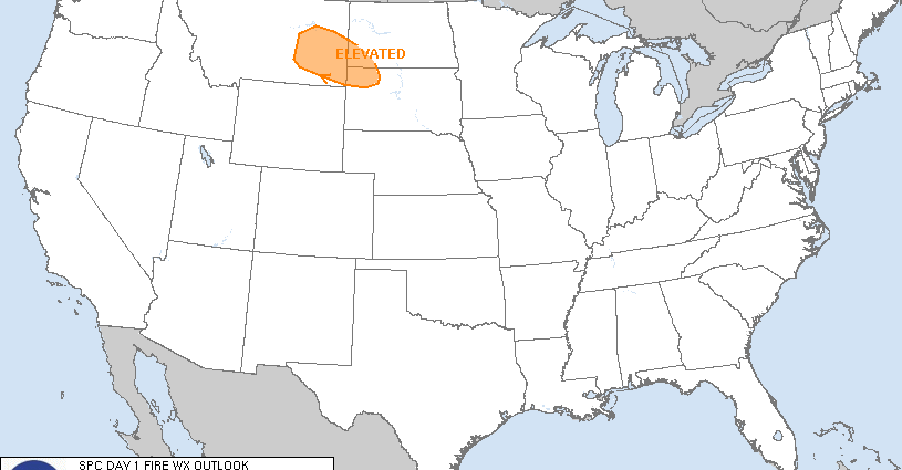
SPC Day 1 Fire Weather Outlook

Day 1 Fire Weather Outlook  
NWS Storm Prediction Center Norman OK
1123 AM CDT Tue Apr 30 2024

Valid 301700Z - 011200Z

Trimmed the northeast portion of the Elevated area based on forecast
frontal position today. Otherwise, the forecast remains on track.
See previous discussion below.

..Bentley.. 04/30/2024

.PREV DISCUSSION... /ISSUED 0110 AM CDT Tue Apr 30 2024/

...Synopsis...
A belt of enhanced mid-level flow will spread across the Northern
Rockies from an upper low across the northwestern US today. A
cold frontal passage will bring rainfall across much of eastern
Montana and Wyoming this morning. Behind the cold front, a dry
continental air mass will overspread this region into the western
Dakotas, with relative humidity dropping as low as 15 percent amid
sustained winds 20-25 mph. Fuels within southern Montana into the
western Dakotas, where less rainfall is forecast, are sufficiently
dry to carry risk of Elevated fire weather concerns.

...Please see www.spc.noaa.gov/fire for graphic product...

Read more

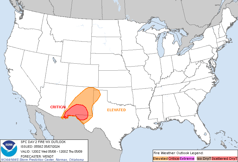
SPC Day 2 Fire Weather Outlook

Day 2 Fire Weather Outlook  
NWS Storm Prediction Center Norman OK
0202 PM CDT Tue Apr 30 2024

Valid 011200Z - 021200Z

...CRITICAL FIRE WEATHER AREA FOR EASTERN NEW MEXICO INTO THE FAR
WESTERN OK/TX PANHANDLES...

No changes. See previous discussion below.

..Bentley.. 04/30/2024

.PREV DISCUSSION... /ISSUED 0151 AM CDT Tue Apr 30 2024/

...Synopsis...
Dry and breezy conditions are expected across the southern High
Plains on Wednesday in response to a development of a lee cyclone,
as increasing mid-level flow overspreads the Rockies. Deeply mixed
profiles by the afternoon will yield single-digit relative humidity
amid sustained winds 20 to 25 mph across portions of eastern New
Mexico into the northern Texas Panhandle. Little recent rainfall
across this area has sufficiently dried fuels, with ERCs forecast to
be in the 75th percentile. This will support Critical fire weather
concerns, with broader Elevated fire weather concerns extending into
southeastern Colorado and the western Oklahoma Panhandle.

...Please see www.spc.noaa.gov/fire for graphic product...

Read more