SPC Sep 21, 2024 0100 UTC Day 1 Convective Outlook
2024-09-20
SPC Convective Outlooks
SPC 0100Z Day 1 Outlook
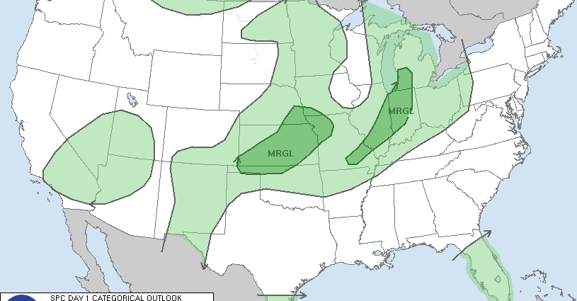
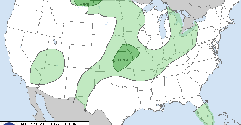
Day 1 Convective Outlook
NWS Storm Prediction Center Norman OK
0743 PM CDT Fri Sep 20 2024

Valid 210100Z - 211200Z

...THERE IS A MARGINAL RISK OF SEVERE THUNDERSTORMS ACROSS PORTIONS
OF THE CENTRAL PLAINS REGION AND OVER THE NORTHERN HIGH PLAINS...

...SUMMARY...
Isolated strong to severe thunderstorms remain possible across parts
of the central Plains region and the northern High Plains.

...01z Update...

Early-evening water-vapor imagery depicts a stubborn upper
anticyclone positioned over TX. There is some indication a weak
disturbance is flattening the height field a bit over KS, per an
elongated cluster of robust convection that extends from west of
CNK-SLN-west of ICT. 00z sounding from TOP exhibits seasonally low
PW value (1.12 in), but ample 0-6km bulk shear for organized
updrafts (40kt). Lower-tropospheric RH is fairly low which may be
contributing to strong wind gusts that have been reported with this
activity. Until the boundary layer cools later this evening there
may be a propensity for locally severe winds with the broken squall
line. While LLJ is not expected to be particularly strong, some
strengthening in the LLJ is expected over the next few hours across
eastern KS and this may allow convection to maintain some intensity
through the mid-evening hours.

A few strong gusts may also be noted with convection as it spreads
east-southeast across northeast MT over the next few hours. 00z
sounding from GGW is strongly sheared and lapse rates are steep.
While the most robust updrafts are lagging the main wind shift, left
exit region of 70kt 500mb jet will translate across this region.
Large-scale should contribute to some longevity with this activity
as it propagates toward northwest ND.

..Darrow.. 09/21/2024
SPC 0100Z Day 1 Outlook

Day 1 Convective Outlook
NWS Storm Prediction Center Norman OK
0743 PM CDT Fri Sep 20 2024

Valid 210100Z - 211200Z

...THERE IS A MARGINAL RISK OF SEVERE THUNDERSTORMS ACROSS PORTIONS
OF THE CENTRAL PLAINS REGION AND OVER THE NORTHERN HIGH PLAINS...

...SUMMARY...
Isolated strong to severe thunderstorms remain possible across parts
of the central Plains region and the northern High Plains.

...01z Update...

Early-evening water-vapor imagery depicts a stubborn upper
anticyclone positioned over TX. There is some indication a weak
disturbance is flattening the height field a bit over KS, per an
elongated cluster of robust convection that extends from west of
CNK-SLN-west of ICT. 00z sounding from TOP exhibits seasonally low
PW value (1.12 in), but ample 0-6km bulk shear for organized
updrafts (40kt). Lower-tropospheric RH is fairly low which may be
contributing to strong wind gusts that have been reported with this
activity. Until the boundary layer cools later this evening there
may be a propensity for locally severe winds with the broken squall
line. While LLJ is not expected to be particularly strong, some
strengthening in the LLJ is expected over the next few hours across
eastern KS and this may allow convection to maintain some intensity
through the mid-evening hours.

A few strong gusts may also be noted with convection as it spreads
east-southeast across northeast MT over the next few hours. 00z
sounding from GGW is strongly sheared and lapse rates are steep.
While the most robust updrafts are lagging the main wind shift, left
exit region of 70kt 500mb jet will translate across this region.
Large-scale should contribute to some longevity with this activity
as it propagates toward northwest ND.

..Darrow.. 09/21/2024
8:47 PMSeptember 20, 2024