SPC Convective Outlooks
SPC 1630Z Day 1 Outlook
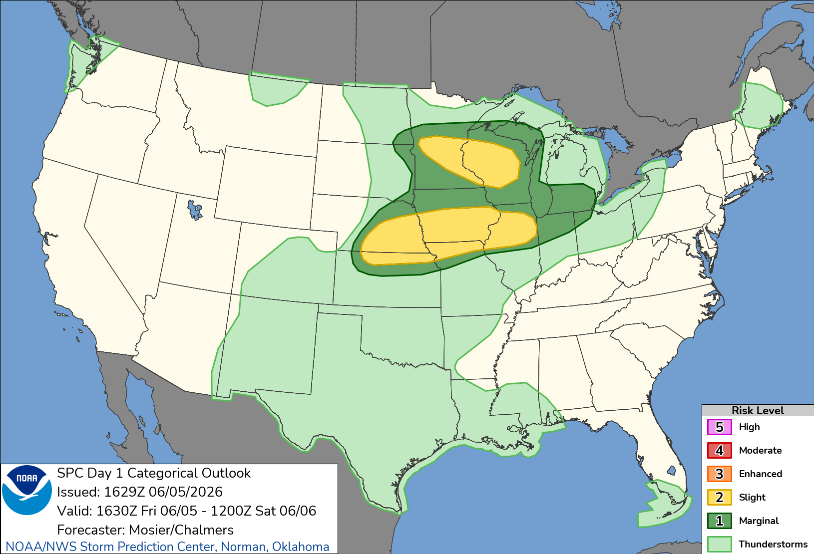
Day 1 Convective Outlook
NWS Storm Prediction Center Norman OK
1129 AM CDT Fri Jun 05 2026

Valid 051630Z - 061200Z

...THERE IS A SLIGHT RISK OF SEVERE THUNDERSTORMS THIS AFTERNOON AND
EVENING FROM NEBRASKA/KANSAS INTO NORTHERN ILLINOIS...AND FROM
CENTRAL MINNESOTA INTO CENTRAL WISCONSIN...

...SUMMARY...
Thunderstorms with large hail and severe wind gusts are expected to
develop late this afternoon and evening from parts of the central
Plains into the mid Missouri and mid Mississippi Valleys. Strong to
severe wind gusts and hail will also be possible in parts of the
upper Mississippi Valley.

...Central Plains into the Mid MS Valley...
Morning surface analysis places a low over northwest KS, near the
intersection of weak lee troughing and the western edge of a remnant
outflow boundary extending across southern NE. Upper 60s/low 70s
dewpoints are already in place east/southeast of this surface low
and outflow boundary. Southerly/southeasterly flow will persist
throughout the day, maintaining a large fetch of low-level moisture
advection from the southern Plains into the Mid MS Valley. Steeper
mid-level lapse rates are also emerging out of the central High
Plains, spreading gradually eastward over these moist low-levels
throughout the day. As a result, a corridor of strong to very strong
buoyancy is anticipated from south-central NE/north-central KS along
the IA/MO border into far west-central IL by the late afternoon.

Expectation is that the outflow boundary will gradually retreat
northward while the cold front progresses slowly southeastward
across SD and NE. Convective initiation is anticipated along both of
these boundaries, beginning over north-central KS/south-central NE
near the surface low at the outflow boundary/cold front
intersection. Most guidance indicates this initiation will occur
after 00Z, but earlier initiation appears possible given moist
low-levels, robust heating, and mesoscale convergence. Recent RAP
soundings indicate minimal convective initiation by 21Z.

Once initiation occurs, strong buoyancy (i.e. MLCAPE over 2500 J/kg)
will support intense updrafts capable of large to isolated very
large hail. Modest deep-layer shear (i.e. effective bulk shear less
than 30 kt) could limit storm organization, with a trend towards a
more outflow-dominant mode. The generally modest mid-level flow also
suggests upscale growth into an organized convective line is low.
Even so, a combination of convergence along the outflow and/or cold
front, as well as modest warm-air advection, will contribute to
additional storm development eastward into the Mid MS Valley.

...Upper Midwest...
Recent surface analysis shows a cold front extending from
north-central WI southwestward through central SD. A low exists
along this boundary near the ND/SD/WI border intersection. This low
is forecast to track eastward along the front as it gradually shifts
southeastward, moving in tandem with a shortwave trough moving
through the northern Plains into the Upper Midwest. Buoyancy will be
more limited here than areas farther south, but still sufficient for
a few stronger, more organized storms, particularly since the
deep-layer vertical shear will be stronger. Discrete storms with
large hail as the primary risk are possible early in the convective
cycle. Thereafter, a trend towards more bowing segments with
damaging gusts is expected. Multiple rounds of storms are possible,
and the overall coverage is expected to be high enough to merit
introducing 15% hail and wind probabilities.

...Lower MI...
An MCV (associated with an overnight MCS) is moving across northern
IL/far southern WI this morning. Activity associated with this MCV
is currently weak and non-severe, but potential for
re-intensification exists this afternoon as activity moves into
northern IN and southern lower MI. Cloud cover introduces some
uncertainty regarding daytime heating and resultant buoyancy.
However, if sufficient daytime heating can occur, steep lapse rates
and mesoscale organization of the MCS could result in sporadic
damaging winds.

..Mosier/Chalmers.. 06/05/2026
12:32 PMJune 5, 2026