
SPC Convective Outlooks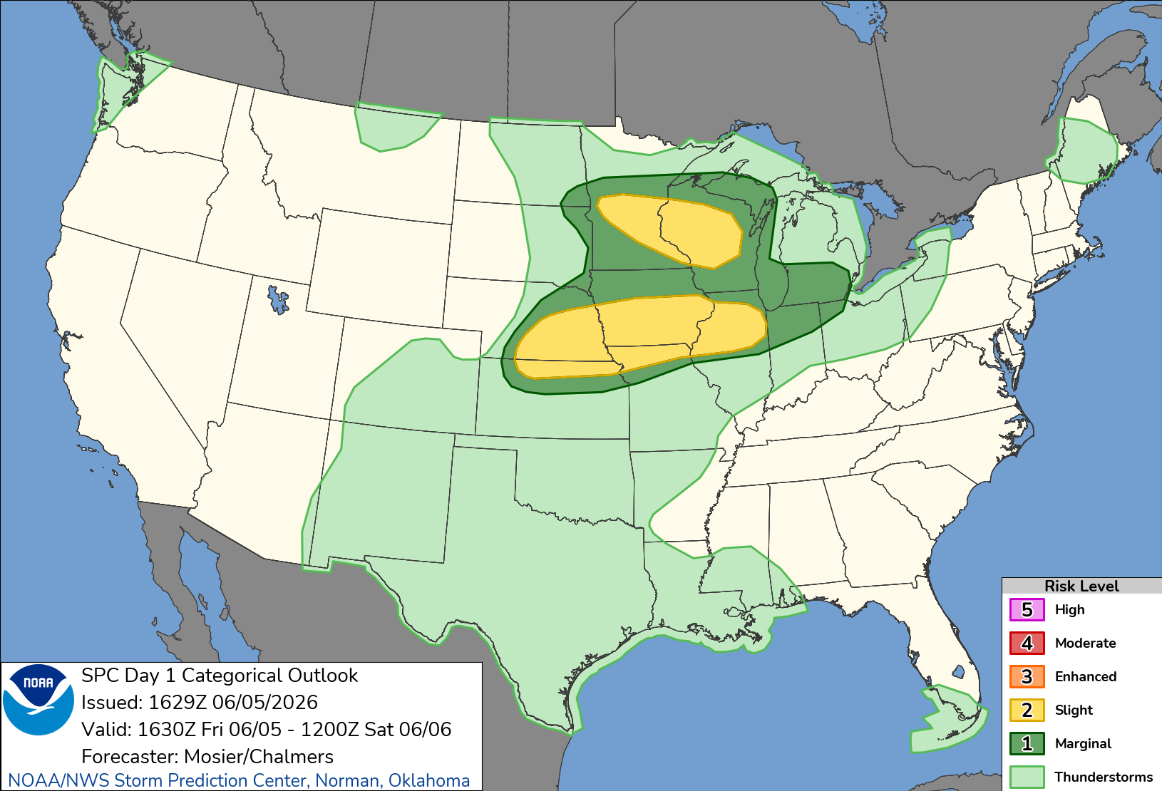
SPC 1300Z Day 1 Outlook
Day 1 Convective Outlook
NWS Storm Prediction Center Norman OK
0700 AM CDT Fri Jun 05 2026

Valid 051300Z - 061200Z

...THERE IS A SLIGHT RISK OF SEVERE THUNDERSTORMS THIS AFTERNOON AND
EVENING FROM NEBRASKA/KANSAS INTO NORTHERN ILLINOIS...

...SUMMARY...
Thunderstorms with large hail and severe wind gusts are expected to
develop late this afternoon and evening from parts of the central
Plains into the mid Missouri and mid Mississippi Valleys. Isolated
severe wind gusts and hail will also be possible in parts of the
upper Mississippi Valley.

...NE to IA...
A large upper ridge is present today across the southern U.S., with
stronger westerlies over the northern tier of states.  One shortwave
trough is noted over SD tracking east-southeastward.  This feature
will provide large-scale ascent to parts of the Midwest states
today, leading to scattered clusters of thunderstorms.  One area of
expected convective initiation will be late this afternoon along a
retreating surface boundary extending from south-central NE into
southern IA.  Ample low-level moisture will reside in the frontal
zone with dewpoints in the low 70s and MLCAPE values over 3000 J/kg.
 Activity should develop around 00z along the boundary and track
slowly eastward.  Sufficient deep-layer shear suggests a risk of
supercells capable of large hail.  Low-level winds are not expected
to be particularly strong, limiting a more robust tornado risk.
Activity will likely congeal and track eastward across southern
IA/northern MO and eventually northern IL through the evening with a
hail/damaging wind risk.

...Northern IL to Lower MI...
A large decaying MCS is moving across northern MO this morning.
While this activity will likely remain non-severe through the
morning, potential for re-intensification exists this afternoon as
activity moves into northern IN and southern lower MI.  If
sufficient daytime heating can occur, steep lapse rates and
mesoscale organization of the MCS could result in sporadic damaging
winds.

...MI/WI...
A broad area of 60s dewpoints and broken cloud cover will lead to
moderate CAPE values this afternoon from southern MN into much of
WI.  As the aforementioned shortwave trough approaches this
afternoon, cooling aloft and strengthening wind fields will promote
organized structures with any convection that can form.  Model
guidance varies considerably on the cover of storms in this area,
but a conditional risk of large hail and damaging winds is present.
Will maintain only MRGL risk for this area for now, but an upgrade
to SLGT could be needed today if later model guidance indicates
greater coverage of afternoon/evening storms.

..Hart/Wendt.. 06/05/2026
SPC 1300Z Day 1 Outlook

Day 1 Convective Outlook
NWS Storm Prediction Center Norman OK
0700 AM CDT Fri Jun 05 2026

Valid 051300Z - 061200Z

...THERE IS A SLIGHT RISK OF SEVERE THUNDERSTORMS THIS AFTERNOON AND
EVENING FROM NEBRASKA/KANSAS INTO NORTHERN ILLINOIS...

...SUMMARY...
Thunderstorms with large hail and severe wind gusts are expected to
develop late this afternoon and evening from parts of the central
Plains into the mid Missouri and mid Mississippi Valleys. Isolated
severe wind gusts and hail will also be possible in parts of the
upper Mississippi Valley.

...NE to IA...
A large upper ridge is present today across the southern U.S., with
stronger westerlies over the northern tier of states.  One shortwave
trough is noted over SD tracking east-southeastward.  This feature
will provide large-scale ascent to parts of the Midwest states
today, leading to scattered clusters of thunderstorms.  One area of
expected convective initiation will be late this afternoon along a
retreating surface boundary extending from south-central NE into
southern IA.  Ample low-level moisture will reside in the frontal
zone with dewpoints in the low 70s and MLCAPE values over 3000 J/kg.
 Activity should develop around 00z along the boundary and track
slowly eastward.  Sufficient deep-layer shear suggests a risk of
supercells capable of large hail.  Low-level winds are not expected
to be particularly strong, limiting a more robust tornado risk.
Activity will likely congeal and track eastward across southern
IA/northern MO and eventually northern IL through the evening with a
hail/damaging wind risk.

...Northern IL to Lower MI...
A large decaying MCS is moving across northern MO this morning.
While this activity will likely remain non-severe through the
morning, potential for re-intensification exists this afternoon as
activity moves into northern IN and southern lower MI.  If
sufficient daytime heating can occur, steep lapse rates and
mesoscale organization of the MCS could result in sporadic damaging
winds.

...MI/WI...
A broad area of 60s dewpoints and broken cloud cover will lead to
moderate CAPE values this afternoon from southern MN into much of
WI.  As the aforementioned shortwave trough approaches this
afternoon, cooling aloft and strengthening wind fields will promote
organized structures with any convection that can form.  Model
guidance varies considerably on the cover of storms in this area,
but a conditional risk of large hail and damaging winds is present.
Will maintain only MRGL risk for this area for now, but an upgrade
to SLGT could be needed today if later model guidance indicates
greater coverage of afternoon/evening storms.

..Hart/Wendt.. 06/05/2026
8:02 AMJune 5, 2026
