SPC Day 1 Fire Weather Outlook
2024-05-06
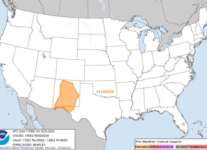
SPC Day 1 Fire Weather Outlook
Day 1 Fire Weather Outlook
NWS Storm Prediction Center Norman OK
1150 AM CDT Mon May 06 2024

Valid 061700Z - 071200Z

...CRITICAL FIRE WEATHER AREA FOR PARTS OF NEW MEXICO INTO FAR
WESTERN TEXAS...

Minimal changes were made to the D1 Fire Weather Outlook. The
Elevated delineation was expanded further west into northwestern New
Mexico and further east into southeastern Kansas and the Oklahoma
Panhandle. These changes were in line with recent trends in
guidance. The Critical area remains unchanged with this outlook. See
previous discussion below for more information.

..Thornton.. 05/06/2024

.PREV DISCUSSION... /ISSUED 0300 AM CDT Mon May 06 2024/

...Synopsis...
A potent shortwave trough will pivot through the Southwest this
morning with mid-level winds remaining strong across the southern
Rockies. A deep surface cyclone will develop in the northern High
Plains with a surface trough extending southward along the lee of
the Rockies. Strong mid-level winds will combine with the strong
surface pressure gradient to promote winds of 20+ mph, particularly
in parts of eastern New Mexico. RH during the afternoon will fall to
near 10-15%. Elevated to critical fire weather is expected given dry
fuels present in New Mexico.

...Please see www.spc.noaa.gov/fire for graphic product...
SPC Day 2 Fire Weather Outlook
2024-05-06
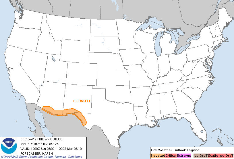
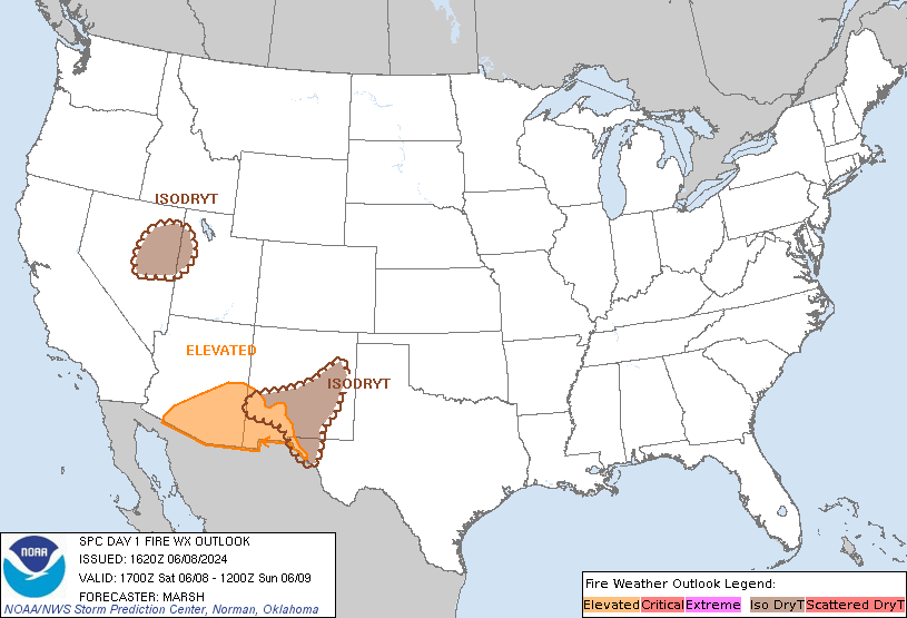
SPC Day 2 Fire Weather Outlook
Day 2 Fire Weather Outlook
NWS Storm Prediction Center Norman OK
0250 PM CDT Mon May 06 2024

Valid 071200Z - 081200Z

...CRITICAL FIRE WEATHER AREA FOR PARTS OF NEW MEXICO INTO THE
SOUTHERN/CENTRAL HIGH PLAINS...

Minor adjustments were made to extend the Elevated delineation into
northwestern New Mexico, where confidence in Elevated fire weather
conditions is high in deterministic and ensemble guidance.
Otherwise, the Critical area remains unchanged. See previous
discussion for more information.

..Thornton.. 05/06/2024

.PREV DISCUSSION... /ISSUED 0302 AM CDT Mon May 06 2024/

...Synopsis...
A broad trough will develop across much of the western and central
U.S. on Tuesday. Strong flow aloft will remain across the southern
Rockies. A deeper surface cyclone is expected to develop in the
southern High Plains as compared to Monday. The coverage and 20+ mph
winds in New Mexico should be somewhat greater as a result. RH will
once again drop to 10-15% during the afternoon. Elevated to critical
fire weather is once again expected. Dry and breezy conditions will
extend into parts of the southern High Plains and western Kansas,
but fuels appear less receptive in these areas.

...Please see www.spc.noaa.gov/fire for graphic product...
SPC MD 653
2024-05-06
SPC Mesoscale Discussions
MD 0653 CONCERNING TORNADO WATCH 187…189… FOR SOUTH-CENTRAL KS
Mesoscale Discussion 0653
NWS Storm Prediction Center Norman OK
0245 PM CDT Mon May 06 2024

Areas affected...South-central KS

Concerning...Tornado Watch 187...189...

Valid 061945Z - 062045Z

The severe weather threat for Tornado Watch 187, 189 continues.

SUMMARY...Initial supercells just east of Dodge City will intensify
as they move eastward across south-central Kansas. Very large hail
with an increasing threat for a strong tornado is anticipated by
21-22z (4-5pm).

DISCUSSION...A trio of convective updrafts continue to build just
east of the Dodge City area. Low-level hodographs remain enlarged
about a county downstream of these supercells. As this activity
spreads east into the greater SRH environment, tornado threat should
be expected to increase rapidly. Modified 18Z DDC sounding with 19Z
surface observations suggest MLCAPE of 2500-3000 J/kg should be
common into south-central KS in the Pratt-Medicine Lodge vicinity.
Lesser buoyancy is still prevalent farther east towards Wichita, but
a 50-80 mile wedge of clearing will promote rapid destabilization
into early evening.

..Grams.. 05/06/2024

...Please see www.spc.noaa.gov for graphic product...

ATTN...WFO...ICT...OUN...DDC...

LAT...LON   38249924 38459798 38029753 37459742 37159763 37039817
            36989903 37059945 37559955 38249924
https://www.spc.noaa.gov/products/md/md0653.htmlSPC Mesoscale Discussions
SPC Center Public Severe Weather Outlook (PWO)
2024-05-06
Public Severe Weather Outlook


PUBLIC SEVERE WEATHER OUTLOOK
NWS STORM PREDICTION CENTER NORMAN OK
0824 AM CDT MON MAY 06 2024

...Outbreak of tornadoes and severe thunderstorms expected over
parts of the central and southern Plains this afternoon and
tonight...

* LOCATIONS...
  Much of Oklahoma
  Central and eastern Kansas

* HAZARDS...
  Numerous tornadoes, several intense and long track
  Widespread large hail, some baseball size
  Scattered damaging winds, some hurricane force

* SUMMARY...
  A regional outbreak of severe weather with multiple strong,
  long-tracked tornadoes, as well as very large hail and severe
  thunderstorm gusts, is expected over parts of the south-central
  Plains from this afternoon through evening.

Preparedness actions...

Review your severe weather safety procedures for the possibility
of dangerous weather today. Stay tuned to NOAA Weather Radio,
weather.gov, or other media for watches and warnings. A tornado
watch means that conditions are favorable for tornadoes to form
during the next several hours. If a tornado warning is issued for
your area, move to a place of safety, ideally in a basement or
interior room on the lowest floor of a sturdy building.

&&

..Grams.. 05/06/2024
SPC MD 652
2024-05-06
SPC Mesoscale Discussions
MD 0652 CONCERNING SEVERE THUNDERSTORM WATCH 188… FOR WESTERN SOUTH DAKOTA
Mesoscale Discussion 0652
NWS Storm Prediction Center Norman OK
0200 PM CDT Mon May 06 2024

Areas affected...Western South Dakota

Concerning...Severe Thunderstorm Watch 188...

Valid 061900Z - 062100Z

The severe weather threat for Severe Thunderstorm Watch 188
continues.

SUMMARY...Thunderstorms continue to show signs of intensification
across western SD. As such, the severe threat across western
portions of WW 183 continues.

DISCUSSION...Over the past 1-2 hours, a trio of discrete cells have
become better organized along a cold front as it shifts
east/northeast. This intensification has been slow, but MRMS
vertically integrated ice and MESH metrics show these cells
approaching severe limits. Additionally, organized mesocyclones have
been noted in velocity data with some of these cells. Although the
effective warm sector remains very narrow immediately ahead of these
cells, continued profile cooling via persistent/strong synoptic
ascent coupled with gradual low-level warming is supporting SBCAPE
values approaching 2000 J/kg. Deep-layer shear vectors and low-level
SRH continues to favor discrete to semi-discrete storm modes with
the potential for large hail and at least a low-end tornado threat -
especially where temperatures have warmed into the low 70s, allowing
for better low-level buoyancy to support stronger lifting/stretching
of environmental SRH and ambient vorticity along the boundary. Given
the very limited extent of the warm sector, the severe threat for
the next 1-2 hours should be relatively confined to areas downstream
of ongoing/developing convection.

..Moore.. 05/06/2024

...Please see www.spc.noaa.gov for graphic product...

ATTN...WFO...ABR...BIS...UNR...BYZ...

LAT...LON   43270156 43800185 44460252 44730320 44880397 45120463
            45450479 45900438 46010400 46020325 45980226 45760154
            45200111 44560082 43950082 43540093 43280103 43220140
            43270156
https://www.spc.noaa.gov/products/md/md0652.htmlSPC Mesoscale Discussions
SPC May 6, 2024 1630 UTC Day 1 Convective Outlook
2024-05-06
SPC 1630Z Day 1 Outlook
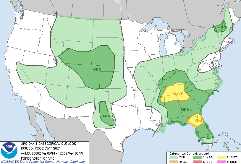

Day 1 Convective Outlook
NWS Storm Prediction Center Norman OK
1102 AM CDT Mon May 06 2024

Valid 061630Z - 071200Z

...THERE IS A HIGH RISK OF SEVERE THUNDERSTORMS FROM CENTRAL AND
NORTHERN OKLAHOMA INTO SOUTH-CENTRAL KANSAS...

...SUMMARY...
A regional outbreak of severe weather with multiple intense (EF3+),
long-tracked tornadoes, as well as very large hail and severe
thunderstorm gusts, is expected over parts of the south-central
Plains from this afternoon through evening.

...NE/KS/OK to north TX...
Water-vapor imagery late this morning shows a potent mid- to
upper-level trough/low over the central Rockies with a speed max
moving through the base of the trough and into the southern and
central High Plains.  This negatively tilted mid level trough will
continue northeast to near the Black Hills by this evening while its
southern portion overspreads the KS/OK corridor.  The 12z Amarillo,
TX raob showed the leading edge of stronger 700-600 mb southwesterly
flow nosing eastward into the High Plains.  A cyclone near the NE
Panhandle this morning will deepen as it moves north-northeast to
the SD/ND border early Tuesday morning.  An associated Pacific front
will push east into the High Plains and overtake the northern
portion of the dryline across parts of the central High Plains this
afternoon into this evening.  Farther south, a dryline will mix east
into western OK by late this afternoon with a broad moist/unstable
warm sector across the southern Great Plains and becoming
increasingly pinched in spatial width farther north into the
north-central Great Plains.  An attendant warm front will advance
northward from OK into the lower MO Valley by early evening and
later into the mid MS Valley.

Visible satellite imagery shows considerable low stratus and
stratocumulus from north TX into the central Great Plains.  The 12z
Fort Worth, TX raob sampled the richer low-level moisture (15 g/kg
lowest 100mb mean mixing ratio) compared to areas farther north.
Surface analysis late this morning shows rapid northward transport
of moisture into OK with 65-70 deg F dewpoints advecting northward
through OK to the KS border.  This plume of richer moisture will
continue northward today beneath an EML and lead to moderate
destabilization over NE with a very to extremely unstable airmass
forecast to develop farther south over the southern half of KS into
OK and adjacent north TX.

Initial thunderstorm development is likely as the upper forcing
impinges on the northwestern periphery of the moist/unstable sector
across the central High Plains (western KS/NE) and northward into SD
with time.  Steep 700-500 mb lapse rates and strengthening flow
becoming more meridional with time will favor organized storms,
including supercells and bands of storms with an associated isolated
to scattered risk for hail/wind and perhaps a few tornadoes.
Farther south, the erosion of the cap is expected initially over the
KS portion of the dryline and perhaps into northwest OK by the mid
afternoon.  Strengthening flow through the column combined with
strong to extreme buoyancy (2500-4500 J/kg MLCAPE) --from I-70 in
central KS to I-40 in central OK-- will strongly favor supercell
development.  Strong upper-level diffluence across the central Great
Plains and intensifying southwesterly to westerly 250-mb flow, which
will result in very long hodographs, will strongly favor discrete
storm modes, at least initially.  Large to giant hail (3-4 inches in
diameter) is possible with the more robust supercells.  The LLJ is
forecast to be strongest over KS northward into the north-central
Plains through 21z.  During the 21-00z timeframe, the flow
associated with the LLJ will strengthen over OK acting to enlarge
hodographs.  Climatologically large combinations of deep-layer
shear, buoyancy, and SRH will result in extreme values of composite
indices (STP 6-12) during the 22z-06z timeframe across the Moderate
to High Risks.  Several discrete supercells are expected to traverse
across a large portion of the Moderate and High-Risk equivalent
tornado probabilities.  Tornadoes, some of which can be intense
(EF3+), are forecast late this afternoon and well into the evening.
Some model guidance shows regenerative supercell development across
central OK this evening.  Have extended the High Risk slightly
farther south to account for this possibility.

...Lower MO Valley/Ozarks/mid MS Valley late...
As greater storm coverage and merging occurs this evening across KS
into northern OK, large-scale ascent will further promote upscale
growth into a severe squall line across eastern KS and moving into
the lower MO Valley and western part of the Ozarks.  Have upgraded
severe-wind probabilities and this resulted in a slight spatial
extension of the Moderate Risk to the east across southeast
KS/northeast OK.  A severe risk will probably continue east to the
MS River overnight with an attendant wind risk and perhaps an
isolated risk for a tornado.

...Northern Plains...
No appreciable change from previous forecast thinking for severe
potential across the northern Plains.  A prefrontal corridor of
favorable moisture and diurnal destabilization will become quite
narrow with north and northwestward extent.  Nonetheless, it should
support scattered thunderstorms in northward-shifting plume, curving
from the western Dakotas (and perhaps parts of extreme northeastern
WY and southeastern MT) southeastward to central NE, and connecting
to the northern part of the central Plains severe threat.  With
strong large-scale lift, cooling aloft, rapidly weakening MLCINH,
and robust low-level mass response/shear expected ahead of the
ejecting shortwave trough, confidence is growing that an arc of
strong-severe thunderstorms will develop, offering large hail,
severe gusts and at least marginal tornado potential.  Even with 50s
to low 60s F surface dewpoints and limited time for substantial
diabatic heating, the net steepening of low/middle level lapse rates
should support peak MLCAPE near or slightly above 1000 J/kg.  Deep
shear may not be particularly intense in a regime of strongly
difluent flow aloft, but still should be adequate for supercell
potential given large lowest-km hodographs possible, and effective
SRH in the 150-300 J/kg range.  Severe potential should diminish
after about 00Z.

...West-central/southwest TX...
Model guidance continues to indicate isolated thunderstorms are
possible in mid/late afternoon along/ ahead of the dryline over
northwest to southwest TX.  Although large-scale/mid-upper forcing
will be negligible (displaced to the north), any pockets of
relatively persistent/maximized low-level lift may aid in local
erosion of the cap and convective initiation.  Mid/upper 60s to low
70s F surface dewpoints and steep low/middle-level lapse rates will
contribute to 3000-4000 J/kg MLCAPE amidst enough deep shear for
supercells.  A conditional significant-hail and marginal tornado
threat exists with sustained supercell(s) -- if any can form.
Coverage concerns preclude more than marginal categorical outlook at
this time.

...Mid South/TN Valley into the southern Appalachians...
A mid-level shortwave trough over TN this morning will continue to
move east into the southern Appalachians today.  An enhanced belt of
westerly mid-level flow accompanying this impulse will overspread
this general region.  In wake of decaying morning convection over
the southern Appalachians, ample heating of a moist boundary layer
will result in moderate destabilization by early-mid afternoon.
Storm redevelopment is forecast this afternoon along and north of a
trailing/diffuse convective boundary over the TN Valley.  Scattered
thunderstorms will probably develop by early to mid afternoon.
Effective shear magnitudes 25-30 kt will support  some organization
in the form of clusters and perhaps transient supercells.  Marginal
Risk equivalent severe probabilities have been added to highlight
this isolated severe threat.

..Smith/Moore.. 05/06/2024
