


AIR QUALITY ADVISORY IN EFFECT UNTIL MIDNIGHT EDT SUNDAY NIGHT…

An Air Quality Advisory for ground level ozone has been issued by the Northeast Ohio Areawide Coordinating Agency. The advisory is until midnight EDT Sunday night.
Air quality levels will be unhealthy for sensitive groups during this period. If you are in the sensitive groups category of children, the elderly and those with breathing difficulties, please monitor your outdoor activity and check air quality readings at airnow.gov. Additionally, sign-up at enviroflash.info for text alerts regarding air quality.
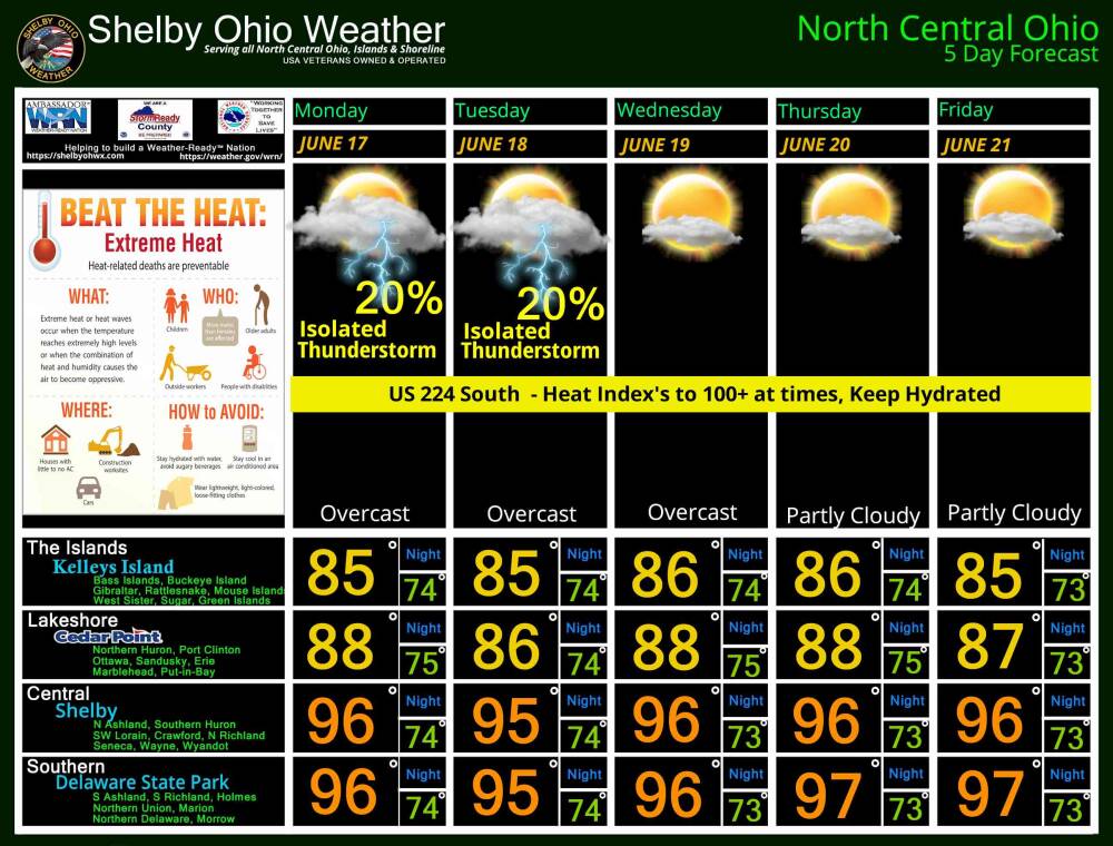
EXCESSIVE HEAT WATCH IN EFFECT FROM MONDAY MORNING THROUGH FRIDAY EVENING… Recently updated !


* WHAT… Prolonged dangerously hot conditions with heat index values in excess of 100 possible.
* WHERE… Portions of north central, northeast, and northwest Ohio and northwest Pennsylvania.
* WHEN… From Monday morning through Friday evening.
* IMPACTS… Heat related illnesses increase significantly during extreme heat and high humidity events.
PRECAUTIONARY/PREPAREDNESS ACTIONS…
Drink plenty of fluids, stay in an air-conditioned room, stay out of the sun, and check up on relatives and neighbors.
Overnight and Tomorrows forecast 6/ 15-16
Tonight – Partly cloudy. Low 56°F. Winds E at 5 to 10 mph.
Tomorrow 6/16 – Partly cloudy. High 89°F. Winds SSE at 5 to 10 mph.
Tomorrow night – Partly cloudy. Low 71°F. Winds S at 5 to 10 mph.
SPC Jun 16, 2024 1300 UTC Day 1 Convective Outlook
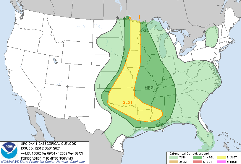
Day 1 Convective Outlook
NWS Storm Prediction Center Norman OK
0753 AM CDT Sun Jun 16 2024

Valid 161300Z - 171200Z

...THERE IS A SLIGHT RISK OF SEVERE THUNDERSTORMS ACROSS THE
NORTH-CENTRAL PLAINS AND UPPER MIDWEST...

...SUMMARY...
Scattered strong to severe storms are possible across the Upper
Mississippi Valley late this afternoon, with additional storms
tonight across the north-central Plains to upper Mississippi Valley,
with large hail the primary risk.

...Northern/Central Plains to the Upper Great Lakes...
Multiple convectively enhanced disturbances/MCVs are noted
regionally including across Wisconsin and northern Missouri,
embedded with the southern fringe of stronger westerlies aloft
located over the Dakotas and Canadian Prairies. Shortwave ridging
will generally be noted over the Upper Midwest/upper Mississippi
Valley vicinity today, with strong warm-sector ample destabilization
in the wake of early day cloud cover and lingering convection. At
least isolated/widely scattered late-day thunderstorm redevelopment
is plausible, most likely near a surface low/triple point across
northern Wisconsin into Upper Michigan, and potentially along the
southwestward-extending cold front along the Minnesota/Iowa border
vicinity. Large hail and damaging winds are possible. A few severe
storms are also possible farther south into areas such as northern
Illinois, potentially influenced by an upstream MCV/prior outflow.

A greater coverage of potentially severe storms is expected into the
evening and beyond, as the low-level jet refocuses and intensifies
across the central Plains after sunset. A strong signal for robust
elevated convection exists across portions of Nebraska/South Dakota
tonight, and this activity should spread northeastward through the
overnight hours. Forecast soundings exhibit substantial MUCAPE (in
excess of 2000 J/kg), with large hail as the primary concern with
the elevated convection.

..Guyer/Leitman.. 06/16/2024
Excessive Heat Watch issued June 16 at 9:20AM EDT until June 21 at 8:00PM EDT by NWS Cleveland OH
Richland County (OHC139) OH* WHAT…Prolonged dangerously hot conditions with heat index values
in excess of 100 degrees possible.
* WHERE…Portions of north central, northeast, and northwest Ohio
and northwest Pennsylvania.
* WHEN…From Monday morning through Friday evening.
* IMPACTS…Heat related illnesses increase significantly during
extreme heat and high humidity events.https://api.weather.gov/alerts/urn:oid:2.49.0.1.840.0.e02d392d582f67068e085b449880a2268bb92300.001.19:30 amJune 16, 2024
Excessive Heat Watch issued June 16 at 9:20AM EDT until June 21 at 8:00PM EDT by NWS Cleveland OH
Wyandot County OHZ027 Ohio* WHAT…Prolonged dangerously hot conditions with heat index values
in excess of 100 degrees possible.
* WHERE…Portions of north central, northeast, and northwest Ohio
and northwest Pennsylvania.
* WHEN…From Monday morning through Friday evening.
* IMPACTS…Heat related illnesses increase significantly during
extreme heat and high humidity events.https://api.weather.gov/alerts/urn:oid:2.49.0.1.840.0.e02d392d582f67068e085b449880a2268bb92300.001.19:29 amJune 16, 2024