

Partly Cloudy and 80 F at Fort Bragg / Simmons Army Airfield, NC
Fort Bragg aka Fort Liberty
Winds are from the West at 11.5 gusting to 17.3 MPH (10 gusting to 15 KT). The pressure is 1002.8 mb and the humidity is 56%.
The heat index is 81.
Last Updated on May 10 2024, 1:55 pm EDT.
The heat index is 81.
Last Updated on May 10 2024, 1:55 pm EDT.
https://w1.weather.gov/data/obhistory/KFBG.html3:03 pmMay 10, 2024
SPC May 10, 2024 1630 UTC Day 1 Convective Outlook
SPC 1630Z Day 1 Outlook
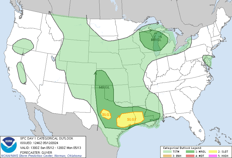
Day 1 Convective Outlook
NWS Storm Prediction Center Norman OK
1126 AM CDT Fri May 10 2024

Valid 101630Z - 111200Z

...THERE IS A SLIGHT RISK OF SEVERE THUNDERSTORMS THIS
AFTERNOON/EVENING FOR SOUTHERN NC/NORTHEAST SC...

...SUMMARY...
Damaging winds of 60-70 mph and large hail of 1-1.75 inches in
diameter will be possible this afternoon/evening across southern
North Carolina and northeast South Carolina.

...Carolinas this afternoon/evening...
A midlevel shortwave trough over the OH Valley will move
southeastward to the Carolinas by this evening with an accompanying
surface cold front.  Surface heating in the wake of debris
cloudiness with the weakening MCS to the south and boundary-layer
dewpoints in the 60s will contribute to a corridor of moderate
buoyancy (MLCAPE near 1500 J/kg) ahead of the front.  Thunderstorm
development is expected by early-mid afternoon along and ahead of
the cold front and a diffuse pre-frontal trough across northern
SC/southern NC, and storms will subsequently spread southeastward
through this evening.  The moderate buoyancy, steepening low-level
lapse rates, and largely straight hodographs with ~50 kt midlevel
flow will favor damaging winds of 60-70 mph and isolated large hail
of 1-1.75 inches in diameter as the main threats with a mix of
supercells and line segments.

...Northeast Gulf coast and FL through this evening...
The initial MCS with damaging winds has now weakened and moved off
the Atlantic coast, with a band of elevated convection persisting to
the west in a zone of warm advection atop the trailing cold pool.
There will be a low-end hail threat with the elevated storms from
the FL Panhandle into north FL today, prior to the storms weakening
later this afternoon.  Additional storm development along the
outflow boundary across the FL peninsula is somewhat uncertain,
given the observed tendency for low-level flow to veer to
west-northwesterly across central FL which suggests only
weak/shallow ascent along the boundary.  Overall, any lingering
severe threat should remain marginal through the afternoon.

...Upper MS Valley...
A midlevel trough over northern MN will continue to dig
southeastward over the upper MS Valley through this evening.
Despite limited low-level moisture, surface heating/steepening
low-level lapse rates and ascent preceding the midlevel trough will
support a band of low-topped convection from mid afternoon through
late evening.  The stronger storms will be capable of producing
isolated wind damage

...Edwards Plateau in TX today...
Though an isolated/elevated storm could occur today well to the
north of the surface cold front, buoyancy appears fairly limited
where storm formation is more probable.  As such, severe storms
appear unlikely (and any storm splits off the high terrain in Mexico
are unlikely to remain severe after crossing the international
border).

..Thompson/Thornton.. 05/10/2024
SPC May 10, 2024 1730 UTC Day 2 Convective Outlook
SPC 1730Z Day 2 Outlook
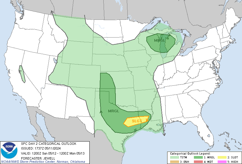
Day 2 Convective Outlook
NWS Storm Prediction Center Norman OK
1230 PM CDT Fri May 10 2024

Valid 111200Z - 121200Z

...THERE IS A MARGINAL RISK OF SEVERE THUNDERSTORMS ACROSS PORTIONS
OF SOUTHEASTERN NEW MEXICO AND WESTERN TEXAS...

...SUMMARY...
Isolated strong to severe thunderstorms may occur Saturday across
portions of the Trans-Pecos and Far West Texas.

...Synopsis...
Mid-level troughing initially over the Upper Great Lakes region is
forecast to shift eastward across the northeastern U.S. Saturday.
Meanwhile, a low over the southwestern states is forecast to shift
eastward across the Four Corners region through the period.

At the surface, a front will continue progressing eastward across
the western Atlantic, while lingering westward across the Florida
Peninsula and Gulf of Mexico, and then west-northwestward across far
West Texas and into New Mexico.  A second/weak front is forecast to
shift southward out of Canada into the northern Plains/Montana late.

...Southeastern New Mexico into western Texas...
Daytime heating of a modestly moist (upper 50s to low 60s dewpoints)
boundary layer across western Texas and into southeastern New
Mexico, in the vicinity of a stalled surface front, will result in
afternoon destabilization across this area.  By late afternoon peak
mixed-layer CAPE values should range from 500 to 1500 J/kg.  This --
combined with ascent provided by the frontal zone, and southeasterly
upslope near higher terrain -- should allow a few storms to develop.
With low-level southeasterlies beneath moderate mid-level
westerlies, shear sufficient for rotating updrafts suggests that a
couple of supercells will be possible, which may linger into the
evening while moving eastward toward the Concho Valley region of
Texas.  Large hail and locally damaging wind gusts would be possible
with the stronger storms, before diminishing by late evening.

..Goss.. 05/10/2024
A Few Clouds and 63 F at Dayton / Wright-Patterson Air Force Base, OH

Winds are North at 12.7 MPH (11 KT). The pressure is 1012.0 mb and the humidity is 44%.
The wind chill is 62.
Last Updated on May 10 2024, 12:55 pm EDT.
Winds are North at 12.7 MPH (11 KT). The pressure is 1012.0 mb and the humidity is 44%.
The wind chill is 62.
Last Updated on May 10 2024, 12:55 pm EDT.
The wind chill is 62.
Last Updated on May 10 2024, 12:55 pm EDT.
Fair and 59 F at Port Clinton Carl R Keller Field Airport, OH

Winds are North at 10.4 MPH (9 KT). The humidity is 59%.
The wind chill is 57.
Last Updated on May 10 2024, 12:15 pm EDT.
Winds are North at 10.4 MPH (9 KT). The humidity is 59%.
The wind chill is 57.
Last Updated on May 10 2024, 12:15 pm EDT.
The wind chill is 57.
Last Updated on May 10 2024, 12:15 pm EDT.