National Weather Service Office Cleveland, Ohio
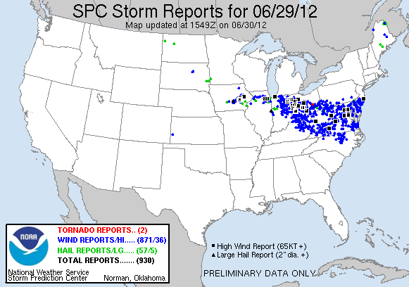
Derecho 6/29/2012 Storm Events
Event Details:
| Event | Thunderstorm Wind |
| Magnitude | 56 kts. |
| State | OHIO |
| County/Area | RICHLAND |
| WFO | CLE |
| Report Source | Trained Spotter |
| NCEI Data Source | CSV |
| Begin Date | 2012-06-29 16:15 EST-5 |
| Begin Location | 1W LEXINGTON |
| Begin Lat/Lon | 40.67/-82.5991 |
| End Date | 2012-06-29 16:30 EST-5 |
| End Location | 3E BUTLER |
| End Lat/Lon | 40.58/-82.3628 |
| Deaths Direct/Indirect | 0/0 (fatality details below, when available…) |
| Injuries Direct/Indirect | 0/0 |
| Property Damage | 1.00M |
| Crop Damage | 0.00K |
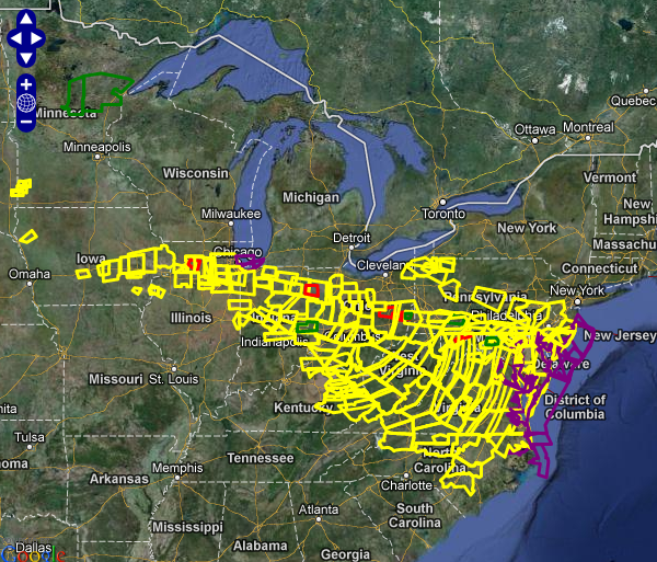
| Episode Narrative | A Derecho developed over northern Indiana during the early afternoon hours of June 29th. This line of storms intensified as it moved across Central Ohio later in the afternoon. Extensive damage was reported in Hancock, Wyandot, Marion, Morrow and Knox Counties. Lesser amounts of damage were reported just to the north of these counties. The damage from this Derecho is comparable to the damage from the remnants of Hurricane Ike in 2008. Hundreds of thousands of people lost power for as long as a week. Power was not fully restored in Hancock County till July 6th. Thousands of trees and hundreds of utility poles were downed by this line of storms. Hundreds of homes and buildings were damaged by winds estimated to be more than 80 mph. A 84 mph wind gust was measured in Findlay. Automated sensors at area airports failed to record peak gusts because of power outages. Dozens of roads and street had to be closed because of fallen trees and power lines. Significant crop losses are also expected. Clean up costs were significant from this storm. Clean up efforts were hampered by an ongoing heat wave with afternoon temperatures as warm as 100 degrees. |
| Event Narrative | An intense line of thunderstorms or Derecho moved across southern Richland County during the afternoon of June 29th causing extensive damage. Winds were estimated to be as much as 65 mph. Over 50 percent of residents in the southern third to half of the county lost power during this event. Power was not completely restored for several days. Hundreds of trees were downed across the county along with many utility poles forcing the closure of some of roads and streets. Damage to homes and buildings was also extensive. Dozens of homes and buildings lost roofing or siding with many other homes damaged by fallen trees. Clean up costs were extensive. The clean up was hampered by an ongoing heat wave with afternoon temperatures in the upper 90s. Significant crop losses are also expected. Damage from this storm in southern Richland County was comparable to the remnants of Hurricane Ike in September 2008. |
Event Map:
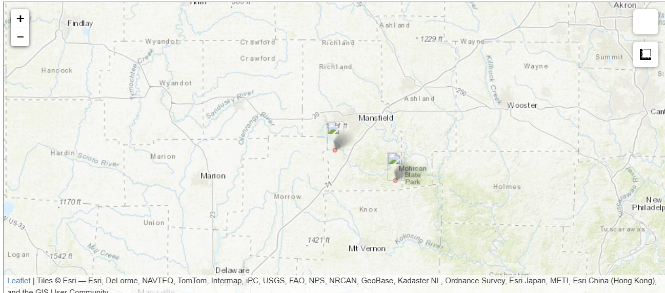
Leaflet | Tiles © Esri — Esri, DeLorme, NAVTEQ, TomTom, Intermap, iPC, USGS, FAO, NPS, NRCAN, GeoBase, Kadaster NL, Ordnance Survey, Esri Japan, METI, Esri China (Hong Kong), and the GIS User Community
All events for this episode:
| Location | County/Zone | St. | Date | Time | T.Z. | Type | Mag | Dth | Inj | PrD | CrD |
|---|---|---|---|---|---|---|---|---|---|---|---|
| Totals: | 0 | 0 | 16.800M | 0.00K | |||||||
| MC COMB | HANCOCK CO. | OH | 06/29/2012 | 15:10 | EST-5 | Thunderstorm Wind | 74 kts. MG | 0 | 0 | 5.000M | 0.00K |
| FINDLAY | HANCOCK CO. | OH | 06/29/2012 | 15:15 | EST-5 | Hail | 0.75 in. | 0 | 0 | 0.00K | 0.00K |
| WHARTON | WYANDOT CO. | OH | 06/29/2012 | 15:25 | EST-5 | Thunderstorm Wind | 70 kts. EG | 0 | 0 | 1.250M | 0.00K |
| MEEKER | MARION CO. | OH | 06/29/2012 | 15:35 | EST-5 | Thunderstorm Wind | 70 kts. EG | 0 | 0 | 4.000M | 0.00K |
| SPRINGVILLE | SENECA CO. | OH | 06/29/2012 | 15:44 | EST-5 | Thunderstorm Wind | 56 kts. MG | 0 | 0 | 300.00K | 0.00K |
| MARION | MARION CO. | OH | 06/29/2012 | 15:45 | EST-5 | Hail | 1.00 in. | 0 | 0 | 0.00K | 0.00K |
| MARION | MARION CO. | OH | 06/29/2012 | 15:47 | EST-5 | Hail | 1.75 in. | 0 | 0 | 0.00K | 0.00K |
| MARION | MARION CO. | OH | 06/29/2012 | 15:49 | EST-5 | Hail | 0.88 in. | 0 | 0 | 0.00K | 0.00K |
| OCEOLA | CRAWFORD CO. | OH | 06/29/2012 | 15:50 | EST-5 | Thunderstorm Wind | 57 kts. MG | 0 | 0 | 800.00K | 0.00K |
| CLIMAX | MORROW CO. | OH | 06/29/2012 | 15:56 | EST-5 | Thunderstorm Wind | 70 kts. EG | 0 | 0 | 2.000M | 0.00K |
| STEAM CORNERS | MORROW CO. | OH | 06/29/2012 | 16:10 | EST-5 | Hail | 1.75 in. | 0 | 0 | 0.00K | 0.00K |
| LEXINGTON | RICHLAND CO. | OH | 06/29/2012 | 16:15 | EST-5 | Thunderstorm Wind | 56 kts. EG | 0 | 0 | 1.000M | 0.00K |
| WATERFORD | KNOX CO. | OH | 06/29/2012 | 16:15 | EST-5 | Thunderstorm Wind | 56 kts. EG | 0 | 0 | 1.400M | 0.00K |
| PERRYSVILLE | ASHLAND CO. | OH | 06/29/2012 | 16:30 | EST-5 | Thunderstorm Wind | 56 kts. EG | 0 | 0 | 750.00K | 0.00K |
| NASHVILLE | HOLMES CO. | OH | 06/29/2012 | 16:35 | EST-5 | Thunderstorm Wind | 52 kts. EG | 0 | 0 | 300.00K | 0.00K |
| Totals: | 0 | 0 | 16.800M | 0.00K |