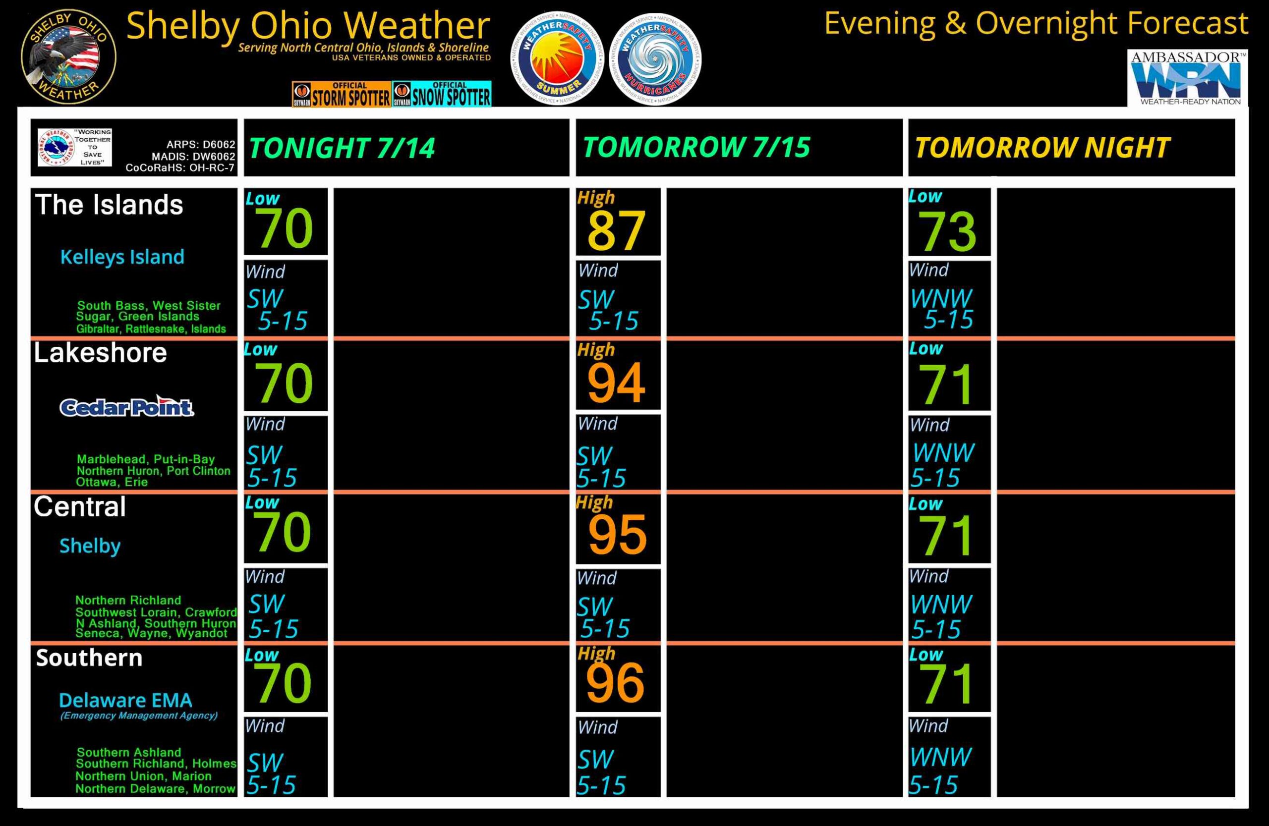
Severe Thunderstorm Warning issued June 14 at 3:04PM EDT until June 14 at 3:45PM EDT by NWS Cleveland OH

Severe Thunderstorm Warning issued June 14 at 3:04PM EDT until June 14 at 3:45PM EDT by NWS Cleveland OHSVRCLE

The National Weather Service in Cleveland has issued a

* Severe Thunderstorm Warning for…
Richland County in north central Ohio…
Ashland County in north central Ohio…
Northwestern Wayne County in northeastern Ohio…

* Until 345 PM EDT.

* At 304 PM EDT, a severe thunderstorm was located over Crestline, or
11 miles east of Bucyrus, moving east at 50 mph.

HAZARD…60 mph wind gusts.

SOURCE…Radar indicated.

IMPACT…Expect damage to trees and power lines.

* Locations impacted include…
Mansfield, Ashland, Shelby, Ontario, New London, Plymouth, West
Salem, Hayesville, Savannah, Polk, Sullivan, Lucas, Jeromesville,
Bailey Lakes, Mifflin, Rowsburg, Nova, Mohicanville, Nankin, and
Shenandoah.SVRCLE

The National Weather Service in Cleveland has issued a

* Severe Thunderstorm Warning for…
Richland County in north central Ohio…
Ashland County in north central Ohio…
Northwestern Wayne County in northeastern Ohio…

* Until 345 PM EDT.

* At 304 PM EDT, a severe thunderstorm was located over Crestline, or
11 miles east of Bucyrus, moving east at 50 mph.

HAZARD…60 mph wind gusts.

SOURCE…Radar indicated.

IMPACT…Expect damage to trees and power lines.

* Locations impacted include…
Mansfield, Ashland, Shelby, Ontario, New London, Plymouth, West
Salem, Hayesville, Savannah, Polk, Sullivan, Lucas, Jeromesville,
Bailey Lakes, Mifflin, Rowsburg, Nova, Mohicanville, Nankin, and
Shenandoah.3:04 PMJune 14, 2026

Special Weather Statement issued June 14 at 3:02PM EDT by NWS Wilmington OH

Special Weather Statement issued June 14 at 3:02PM EDT by NWS Wilmington OHAt 302 PM EDT, strong thunderstorms were located along a line
extending from near Marion to 7 miles southeast of West Mansfield,
moving east at 35 mph.

HAZARD…Wind gusts up to 45 mph and very heavy rain.

SOURCE…Radar indicated.

IMPACT…Gusty winds could knock down tree limbs and blow around
unsecured objects. Visibility will be poor and hydroplaning
is possible.

Locations impacted include…
Delaware, Marysville, Sunbury, Richwood, Ashley, Radnor, Galena,
Ostrander, Magnetic Springs, Alum Creek State Park, Delaware State
Park, Raymond, Olive Green, Broadway, Warrensburg, Pottersburg,
Kilbourne, Essex, Interstate 71 at US Route 36/State Route 37, and
Stratford.

This includes I-71 in Ohio between mile markers 126 and 138.

If outdoors, consider seeking shelter inside a sturdy building.

Motorists should slow down and use extra caution.

A Severe Thunderstorm Watch remains in effect until 900 PM EDT for
central and west central Ohio.

To report hazardous weather conditions, go to our website at
weather.gov/iln and submit your report via social media, when you can
do so safely.At 302 PM EDT, strong thunderstorms were located along a line
extending from near Marion to 7 miles southeast of West Mansfield,
moving east at 35 mph.

HAZARD…Wind gusts up to 45 mph and very heavy rain.

SOURCE…Radar indicated.

IMPACT…Gusty winds could knock down tree limbs and blow around
unsecured objects. Visibility will be poor and hydroplaning
is possible.

Locations impacted include…
Delaware, Marysville, Sunbury, Richwood, Ashley, Radnor, Galena,
Ostrander, Magnetic Springs, Alum Creek State Park, Delaware State
Park, Raymond, Olive Green, Broadway, Warrensburg, Pottersburg,
Kilbourne, Essex, Interstate 71 at US Route 36/State Route 37, and
Stratford.

This includes I-71 in Ohio between mile markers 126 and 138.

If outdoors, consider seeking shelter inside a sturdy building.

Motorists should slow down and use extra caution.

A Severe Thunderstorm Watch remains in effect until 900 PM EDT for
central and west central Ohio.

To report hazardous weather conditions, go to our website at
weather.gov/iln and submit your report via social media, when you can
do so safely.3:02 PMJune 14, 2026

DMCA compliant image