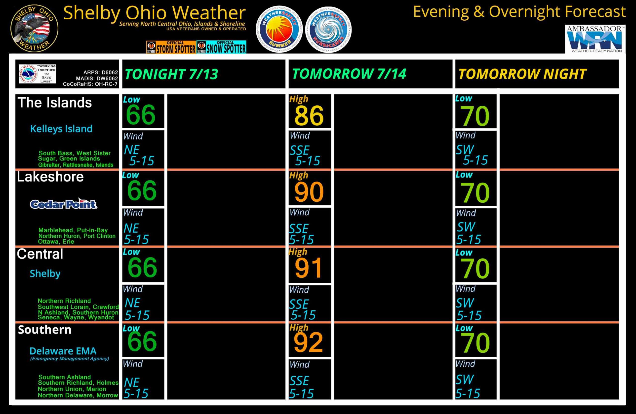
Severe Thunderstorm Warning issued June 14 at 1:15PM EDT until June 14 at 2:15PM EDT by NWS Cleveland OH

Severe Thunderstorm Warning issued June 14 at 1:15PM EDT until June 14 at 2:15PM EDT by NWS Cleveland OHSVRCLE

The National Weather Service in Cleveland has issued a

* Severe Thunderstorm Warning for…
Ottawa County in northwestern Ohio…
Central Sandusky County in northwestern Ohio…
Northern Wood County in northwestern Ohio…
Lucas County in northwestern Ohio…

* Until 215 PM EDT.

* At 115 PM EDT, a severe thunderstorm was located over Rossford, or
near Toledo, moving east at 45 mph.

HAZARD…60 mph wind gusts and penny size hail.

SOURCE…Radar indicated.

IMPACT…Expect damage to trees and power lines.

* Locations impacted include…
Toledo, Bowling Green, Fremont, Port Clinton, Perrysburg, Oregon,
Rossford, Waterville, Northwood, Whitehouse, Oak Harbor,
Gibsonburg, Genoa, Woodville, Holland, Weston, Elmore, Maumee,
Ottawa Hills, and Walbridge.SVRCLE

The National Weather Service in Cleveland has issued a

* Severe Thunderstorm Warning for…
Ottawa County in northwestern Ohio…
Central Sandusky County in northwestern Ohio…
Northern Wood County in northwestern Ohio…
Lucas County in northwestern Ohio…

* Until 215 PM EDT.

* At 115 PM EDT, a severe thunderstorm was located over Rossford, or
near Toledo, moving east at 45 mph.

HAZARD…60 mph wind gusts and penny size hail.

SOURCE…Radar indicated.

IMPACT…Expect damage to trees and power lines.

* Locations impacted include…
Toledo, Bowling Green, Fremont, Port Clinton, Perrysburg, Oregon,
Rossford, Waterville, Northwood, Whitehouse, Oak Harbor,
Gibsonburg, Genoa, Woodville, Holland, Weston, Elmore, Maumee,
Ottawa Hills, and Walbridge.1:20 PMJune 14, 2026

Special Marine Warning issued June 14 at 1:01PM EDT until June 14 at 2:30PM EDT by NWS Cleveland OH

Special Marine Warning issued June 14 at 1:01PM EDT until June 14 at 2:30PM EDT by NWS Cleveland OHSMWCLE

The National Weather Service in Cleveland has issued a

* Special Marine Warning for…
Nearhsore waters from Maumee Bay OH to Vermilion OH…
Open waters from Maumee Bay OH to The Islands OH…

* Until 230 PM EDT.

* At 100 PM EDT, strong thunderstorms were located along a line
extending from 8 nm south of Belle Isle to Bolles Harbor Of Refuge
to 12 nm southwest of North Cape, moving east at 30 knots.

HAZARD…Wind gusts 34 knots or greater.

SOURCE…Radar.

IMPACT…Small craft could be damaged in briefly higher winds and
suddenly higher waves.

* Locations impacted include…
Reno Beach, Put-In-Bay, Kelleys Island, and Sandusky Bay.SMWCLE

The National Weather Service in Cleveland has issued a

* Special Marine Warning for…
Nearhsore waters from Maumee Bay OH to Vermilion OH…
Open waters from Maumee Bay OH to The Islands OH…

* Until 230 PM EDT.

* At 100 PM EDT, strong thunderstorms were located along a line
extending from 8 nm south of Belle Isle to Bolles Harbor Of Refuge
to 12 nm southwest of North Cape, moving east at 30 knots.

HAZARD…Wind gusts 34 knots or greater.

SOURCE…Radar.

IMPACT…Small craft could be damaged in briefly higher winds and
suddenly higher waves.

* Locations impacted include…
Reno Beach, Put-In-Bay, Kelleys Island, and Sandusky Bay.1:01 PMJune 14, 2026

DMCA compliant image