Sticky

SPC Sep 20, 2024 1300 UTC Day 1 Convective Outlook
2024-09-20
SPC Convective Outlooks
SPC 1300Z Day 1 Outlook
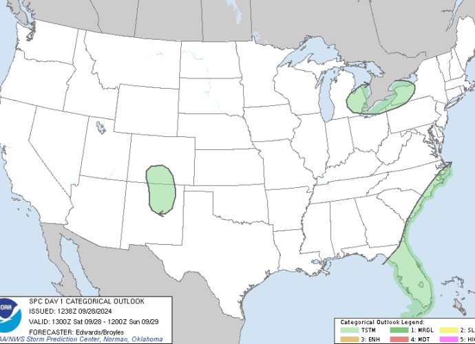
Day 1 Convective Outlook
NWS Storm Prediction Center Norman OK
0743 AM CDT Fri Sep 20 2024

Valid 201300Z - 211200Z

...THERE IS A MARGINAL RISK OF SEVERE THUNDERSTORMS FROM SOUTHWEST
LOWER MICHIGAN INTO PARTS OF ILLINOIS...INDIANA...AND SOUTHEAST
MISSOURI...AND OVER PARTS OF THE CENTRAL PLAINS...

...SUMMARY...
Isolated strong to severe thunderstorms are possible during the late
afternoon over parts of southwest Lower Michigan, Illinois, Indiana,
and southeast Missouri. Isolated strong to severe storms are also
possible across parts of the south-central Plains.

...Synopsis...
Shortwave trough currently moving through WI and Upper MI will
continue eastward through the Upper Great Lakes region today.
Another shortwave trough will follow quickly in its wake,
progressing across Alberta, Saskatchewan, and Manitoba, and adjacent
portions of MT and the northern Plains this evening and overnight.
Father south, a deep upper low with seasonably cold mid-level
temperatures will move from southern CA into AZ. Progression of this
low will dampen the northwestern periphery of the upper ridging
centered over TX.

A surface low attendant to this WI/Upper MI shortwave trough is
currently near the IA/WI/IL border intersection, with weak cold
front extending southwestward from this low to another subtle
surface low over the central OK/KS border. Surface troughing
continues southwestward from this secondary low, but this portion of
the boundary has taken on more warm-front-like characteristics over
the past several hours (evidenced by the dewpoint increase of 3-4
deg F over the past 3 hours across the eastern TX/OK Panhandle).
Enhanced westerly/southwesterly flow aloft attendant to both the
central Canada/MT shortwave trough and CA upper low will contribute
to sharpening surface lee troughing throughout the day and into this
evening.

...Central Plains...
Low-level moisture is expected to advect northward/northwestward
throughout the day as Thursday's cold front returns northward as a
warm front. As a result, low to mid 60s dewpoints will likely be in
place across south-central/southeast KS during the late afternoon.
Dewpoints will likely be in upper 50s farther west in southwest KS,
with notably drier conditions across the adjacent TX/OK Panhandles
where downsloping southwesterly surface winds are likely.

Southwesterly flow aloft ahead of the approaching upper low will
advect steep mid-level lapse rates northeastward through the
southern High Plains into western portions of the central Plains.
Modest buoyancy is anticipated during the late afternoon where these
lapse rates overlay the more favorable low-level moisture across
southern KS. Limited large-scale ascent and low-level confluence
near the warm front is anticipated over this region as well, with
isolated to widely scattered high-based thunderstorm anticipated.
Vertical shear will be modest, but still strong enough for
persist/organized storm structures, and the potential for some
strong gusts with the more robust storms. Some isolated hail is also
possible over south-central KS where buoyancy is maximized.

Low-level moisture will continue advection northward during the
evening and overnight, with a strengthening low-level jet
anticipated as well. Consequently, additional thunderstorm
development is expected after 04Z over northeast KS and adjacent far
southeast NE and northwest MO. Isolated hail is possible with the
strongest storms.

...Southwestern Lower MI into IN, IL, and southeast MO...
Upper 60s to low 70s dewpoints are expected from southwest Lower MI
southwestward across western IN, southern IL, and southeast MO.
Daytime heating of this moist low-level air mass will yield a
moderately unstable and uncapped air mass ahead of the approaching
front, and thunderstorm development is anticipated as the front
interacts with this airmass. Moderate vertical shear will be in
place, but poor lapse rates and notable mid-level dry air could make
updraft maintenance difficult. As such, a more multicellular storm
mode is anticipated. Highest storm coverage is expected over
southwest Lower MI and western IN, with warm mid-level temperatures
likely limiting coverage across southern IL and southeast MO.
Locally strong gusts will be the primary severe risk, with isolated,
marginally severe hail possible as well.

..Mosier/Broyles.. 09/20/2024
8:47 AMSeptember 20, 2024
SPC Day 2 Fire Weather Outlook
2024-09-20
SPC Fire Weather Outlooks
SPC Day 2 Fire Weather Outlook
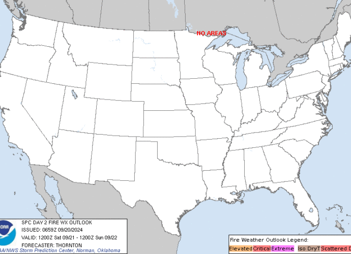
Day 2 Fire Weather Outlook
NWS Storm Prediction Center Norman OK
0159 AM CDT Fri Sep 20 2024

Valid 211200Z - 221200Z

...NO CRITICAL AREAS...

...Synopsis...
Fire weather concerns will remain low across the CONUS on Saturday
as a cold front brings cooler temperatures and increasing
precipitation chances across much of the central/northern Plains.
Brief periods of Elevated fire weather concerns will be possible
across portions of New Mexico as enhanced mid-level flow rounds the
western US upper low. Fuels across this region remain unsupportive
of large-fire spread at this time with potential for additional
rainfall from thunderstorm activity on Saturday. As such, no areas
were included with this outlook.

..Thornton.. 09/20/2024

...Please see www.spc.noaa.gov/fire for graphic product...
3:00 AMSeptember 20, 2024