AIR QUALITY ADVISORY IN EFFECT UNTIL MIDNIGHT EDT SUNDAY NIGHT…

An Air Quality Advisory for ground level ozone has been issued by the Northeast Ohio Areawide Coordinating Agency. The advisory is until midnight EDT Sunday night.

Air quality levels will be unhealthy for sensitive groups during this period. If you are in the sensitive groups category of children, the elderly and those with breathing difficulties, please monitor your outdoor activity and check air quality readings at airnow.gov. Additionally, sign-up at enviroflash.info for text alerts regarding air quality.

EXCESSIVE HEAT WATCH IN EFFECT FROM MONDAY MORNING THROUGH FRIDAY EVENING…   Recently updated !

* WHAT… Prolonged dangerously hot conditions with heat index values in excess of 100 possible.

* WHERE… Portions of north central, northeast, and northwest Ohio and northwest Pennsylvania.

* WHEN… From Monday morning through Friday evening.

* IMPACTS… Heat related illnesses increase significantly during extreme heat and high humidity events.

PRECAUTIONARY/PREPAREDNESS ACTIONS…

Drink plenty of fluids, stay in an air-conditioned room, stay out of the sun, and check up on relatives and neighbors.


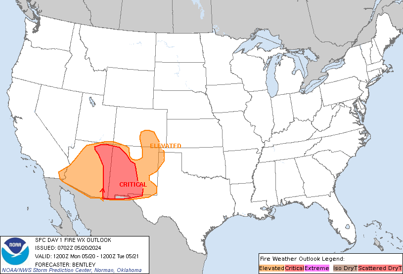
SPC Day 1 Fire Weather Outlook

SPC Day 1 Fire Weather Outlook

Day 1 Fire Weather Outlook  
NWS Storm Prediction Center Norman OK
0151 AM CDT Sun Jun 16 2024

Valid 161200Z - 171200Z

...CRITICAL FIRE WEATHER AREA FOR SOUTHERN UTAH...NORTHERN
ARIZONA...AND FAR SOUTHEAST NEVADA...

...Synopsis...
A deepening western trough will bring an increase in southwesterly
flow across much of the desert Southwest this afternoon. Fuels in
this region have seen significant drying after several days of warm
and dry conditions. Guidance indicates fuels in this region are
critically dry, with recent ERCs data indicating 90th percentile for
dryness across much of northern and central Arizona. This is further
supported by active recent fire activity in this region. Relative
humidity reductions to 5-10 percent will overlap sustained winds
15-20 mph across central/northern Arizona, southern Utah, and far
southeastern Nevada where a Critical delineation was maintained with
this outlook. Outside of this region, a more broad area of Elevated
fire weather conditions will be possible across much of
central/southern Utah into southern Arizona, where there is less
confidence is sustained Critical wind speeds. 

Elevated conditions may also extend into portions of western Nevada
in the lee of the Sierras. In this region, afternoon relative
humidity reductions to 15-20 percent will overlap sustained winds
10-15 mph (locally higher) amid modestly receptive fuels.

..Thornton.. 06/16/2024

...Please see www.spc.noaa.gov/fire for graphic product...

Read more


SPC Day 2 Fire Weather Outlook

SPC Day 2 Fire Weather Outlook

Day 2 Fire Weather Outlook  
NWS Storm Prediction Center Norman OK
0155 AM CDT Sun Jun 16 2024

Valid 171200Z - 181200Z

...CRITICAL FIRE WEATHER AREA FOR NORTHEASTERN
ARIZONA...SOUTHEASTERN UTAH...PORTIONS OF WESTERN NEW MEXICO...

...Synopsis...
A secondary shortwave will rotate through the western US trough on
Monday, bringing continued strong southwesterly flow across much of
the desert southwest into the southern High Plains. 

Across northeastern Arizona, southeastern Utah, and portions of
western New Mexico, afternoon relative humidity reductions to 10-15
percent will overlap sustained winds around 20 mph. Fuels in this
region are critically dry, supporting maintaining a Critical
delineation across these regions on Monday. Broader Elevated fire
weather concerns are expected across much of Arizona into
southern/central Utah, eastern Nevada, and into western New Mexico
and southern Colorado. 

Elevated fire weather concerns are also expected as strong
northwesterly flow at 10-15 mph on the backside of the trough
overlaps relative humidity reductions to 15-20 percent (locally
around 10 percent) within the Sacramento Valley and San Joaquin
Valley in northern/central California. Fuels within this region are
sufficiently dry to support Elevated fire weather concerns.

..Thornton.. 06/16/2024

...Please see www.spc.noaa.gov/fire for graphic product...

Read more


SPC Jun 16, 2024 0600 UTC Day 1 Convective Outlook

SPC 1200Z Day 1 Outlook

Day 1 Outlook Image

Day 1 Convective Outlook  
NWS Storm Prediction Center Norman OK
1240 AM CDT Sun Jun 16 2024

Valid 161200Z - 171200Z

...THERE IS A SLIGHT RISK OF SEVERE THUNDERSTORMS ACROSS PORTIONS OF
THE NORTHERN/CENTRAL PLAINS INTO THE UPPER GREAT LAKES...

...SUMMARY...
Scattered strong to severe storms are expected this evening and
overnight from parts of the northern Plains into the upper
Mississippi Valley, with hail the primary risk.

...Northern/Central Plains to the upper Great Lakes...

Northern Rockies short-wave trough will eject northeast across SK/MB
into western ON by 17/00z. This feature is expected to partially
influence the upper Great Lakes region, with only weak height falls
glancing northern portions of MN. Otherwise, the primary concern for
the upper Great Lakes will be the early-day short-wave trough that
will eject across WI/MI. This feature is currently located over
western IA but convection has weakened considerably despite the
large-scale support. Current thinking is non-severe convection
should spread northeast across WI into the U.P. of MI early within a
warm advection corridor.

Weak short-wave ridging will be noted across much of the upper MS
Valley in the wake of the early-day feature. The boundary that
surges across MN, arcing back into the central Plains will provide a
focus for low-level convergence; however, boundary-layer heating may
be inadequate for appreciable surface-based convection until late in
the day. Latest models are not aggressive in developing convection
along the boundary, but rather generate elevated convection north of
the wind shift later in the evening as the LLJ refocuses over the
central Plains after sunset. A strong signal for robust elevated
convection exists across portions of SD/NE during the latter half of
the period, and this activity should spread northeast during the
overnight hours. Forecast soundings exhibit substantial MUCAPE (in
excess of 2000 J/kg), if lifting parcels above 850mb within the
strengthening warm-advection zone. Hail should be the primary
concern with the elevated convection.

..Darrow/Thornton.. 06/16/2024

Read more


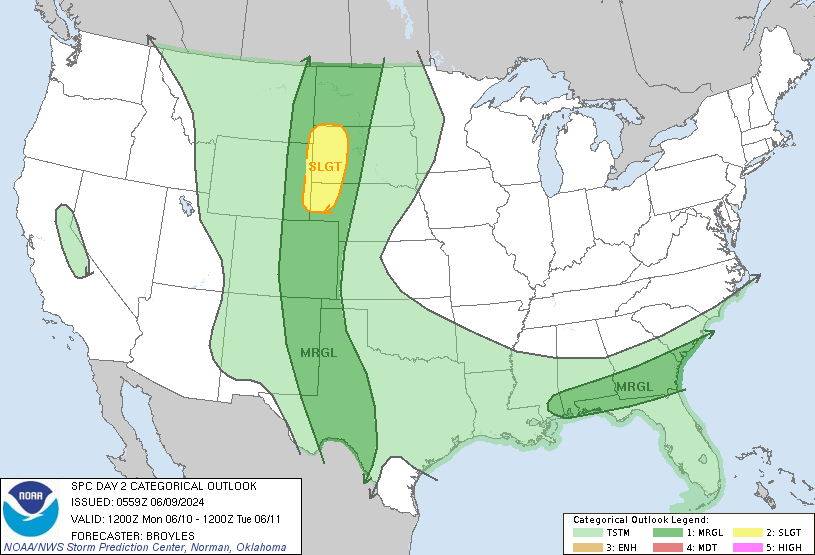
SPC Jun 16, 2024 0600 UTC Day 2 Convective Outlook

SPC 0600Z Day 2 Outlook

Day 2 Outlook Image

Day 2 Convective Outlook  
NWS Storm Prediction Center Norman OK
1243 AM CDT Sun Jun 16 2024

Valid 171200Z - 181200Z

...THERE IS A SLIGHT RISK OF SEVERE THUNDERSTORMS OVER PARTS OF THE
NORTHERN PLAINS AND UPPER MISSISSIPPI VALLEY...

...SUMMARY...
Scattered strong to severe storms will be possible Monday over much
of the northern Plains toward the upper Mississippi Valley.

...Synopsis...
On Monday, strong southwest flow aloft will extend from the Great
Basin into the northern Plains and upper MS Valley, with an early
lead wave over MN and the primary trough over the Pacific Northwest.
Height rises will occur over much of the northern Plains during the
day, before cooling aloft spreads east across the northern Rockies
and High Plains late. Meanwhile, an upper ridge will remain over the
East.

At the surface, low pressure will form over WY and CO, with a warm
front from NE into southern MN and northern WI by 00Z. South of this
front, mid to upper 60s F dewpoints will be common. Overnight, a
cold front will push east across the Dakotas and toward central NE,
as warming continues north across the upper MS Valley. The surface
low will translate northeast from CO toward ND by 12Z Tue.

...Northern Plains and upper MS Valley...
Early day storms and rain are expected from eastern SD across MN and
into northern WI and upper MI, with a gradual decrease in coverage
throughout the day. This activity will be well north of the warm
front, and rain cooled air could reinforce the boundary for much of
the day.

By late afternoon, an unstable air mass along and south of this
front may lead to renewed development, and a few storms could
produce gusty winds or marginal hail. Additional storms are likely
down the dryline into southwest NE into western KS where low-level
lapse rates will be steep. Locally large hail or strong winds will
be possible.

During the evening and overnight, a greater threat of strong to
severe storms may materialize as the warm front surges north along
with southerly 850 mb winds increasing to 60 kt over a broad area.
In addition the low-level moisture flux, the surging cold front will
add lift, with the end result areas of storms capable of hail and
locally damaging gusts. A greater severe risk than forecast for
damaging winds may exist along the boundary, especially if it moves
farther north than forecast with earlier air mass recovery.

..Jewell.. 06/16/2024

Read more