AIR QUALITY ADVISORY IN EFFECT UNTIL MIDNIGHT EDT SUNDAY NIGHT…

An Air Quality Advisory for ground level ozone has been issued by the Northeast Ohio Areawide Coordinating Agency. The advisory is until midnight EDT Sunday night.

Air quality levels will be unhealthy for sensitive groups during this period. If you are in the sensitive groups category of children, the elderly and those with breathing difficulties, please monitor your outdoor activity and check air quality readings at airnow.gov. Additionally, sign-up at enviroflash.info for text alerts regarding air quality.


EXCESSIVE HEAT WATCH IN EFFECT FROM MONDAY MORNING THROUGH FRIDAY EVENING…   Recently updated !

* WHAT… Prolonged dangerously hot conditions with heat index values in excess of 100 possible.

* WHERE… Portions of north central, northeast, and northwest Ohio and northwest Pennsylvania.

* WHEN… From Monday morning through Friday evening.

* IMPACTS… Heat related illnesses increase significantly during extreme heat and high humidity events.

PRECAUTIONARY/PREPAREDNESS ACTIONS…

Drink plenty of fluids, stay in an air-conditioned room, stay out of the sun, and check up on relatives and neighbors.


NHC Atlantic Outlook


Atlantic 2-Day Graphical Outlook Image


Atlantic 7-Day Graphical Outlook Image

ZCZC MIATWOAT ALL
TTAA00 KNHC DDHHMM

Tropical Weather Outlook
NWS National Hurricane Center Miami FL
800 AM EDT Sun Jun 16 2024

For the North Atlantic…Caribbean Sea and the Gulf of Mexico:

1. Southwestern Gulf of Mexico:
A large area of disturbed weather has formed over Central
America, the Yucatan Peninsula of Mexico, and the adjacent waters
of the northwestern Caribbean Sea. A broad area of low pressure is
forecast to form from this system over the southwestern Gulf of
Mexico in a day or two. Environmental conditions appear conducive
for gradual development of this system, and a tropical depression
could form by midweek while it moves slowly westward or
west-northwestward. Regardless of development, several days of
heavy rainfall are expected across portions of southern Mexico and
Central America. These rains are likely to cause life-threatening
flooding and flash flooding.
* Formation chance through 48 hours…low…10 percent.
* Formation chance through 7 days…medium…60 percent.

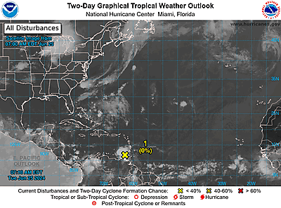
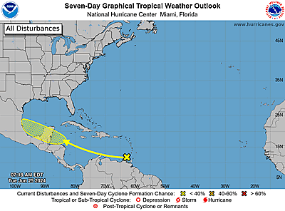
2. Southwestern Atlantic Ocean:
An area of low pressure is forecast to form by midweek a few
hundred miles northeast of the central Bahamas. Environmental
conditions could be conducive for some development of this system
thereafter while it moves westward or west-northwestward.
* Formation chance through 48 hours…low…near 0 percent.
* Formation chance through 7 days…low…30 percent.

Forecaster Beven


NHC Eastern North Pacific Outlook


Eastern North Pacific 2-Day Graphical Outlook Image


Eastern North Pacific 7-Day Graphical Outlook Image

ZCZC MIATWOEP ALL
TTAA00 KNHC DDHHMM

Tropical Weather Outlook
NWS National Hurricane Center Miami FL
500 AM PDT Sun Jun 16 2024

For the eastern North Pacific…east of 140 degrees west longitude:

1. Offshore Central America:
A trough of low pressure centered just offshore of the southern
coast of Guatemala continues to produce disorganized showers and
thunderstorms. Environmental conditions are conducive for some
development of this system, and a short-lived tropical depression
could form early next week if the system stays offshore.
Regardless of development, several days of heavy rainfall are
expected across portions of southern Mexico and Central America.
These rains are likely to cause life-threatening flooding and flash
flooding.
* Formation chance through 48 hours…low…20 percent.
* Formation chance through 7 days…low…20 percent.

Forecaster Pasch


SPC Day 1 Fire Weather Outlook

SPC Day 1 Fire Weather Outlook

Day 1 Fire Weather Outlook  
NWS Storm Prediction Center Norman OK
0151 AM CDT Sun Jun 16 2024

Valid 161200Z - 171200Z

...CRITICAL FIRE WEATHER AREA FOR SOUTHERN UTAH...NORTHERN
ARIZONA...AND FAR SOUTHEAST NEVADA...

...Synopsis...
A deepening western trough will bring an increase in southwesterly
flow across much of the desert Southwest this afternoon. Fuels in
this region have seen significant drying after several days of warm
and dry conditions. Guidance indicates fuels in this region are
critically dry, with recent ERCs data indicating 90th percentile for
dryness across much of northern and central Arizona. This is further
supported by active recent fire activity in this region. Relative
humidity reductions to 5-10 percent will overlap sustained winds
15-20 mph across central/northern Arizona, southern Utah, and far
southeastern Nevada where a Critical delineation was maintained with
this outlook. Outside of this region, a more broad area of Elevated
fire weather conditions will be possible across much of
central/southern Utah into southern Arizona, where there is less
confidence is sustained Critical wind speeds. 

Elevated conditions may also extend into portions of western Nevada
in the lee of the Sierras. In this region, afternoon relative
humidity reductions to 15-20 percent will overlap sustained winds
10-15 mph (locally higher) amid modestly receptive fuels.

..Thornton.. 06/16/2024

...Please see www.spc.noaa.gov/fire for graphic product...

Read more