Overnight and Tomorrows forecast 5- 9/10
Tonight – 40% Showers and T-storms. Low 47°F. Wind N, 5 to 15 mph.
Tomorrow 5/10 – 20% Showers before 10am, High 59°F. Wind N, 5 to 15 mph.
Tomorrow night – Overcast, Low 43°F. Wind N, 5 to 10 mph.
Tonight – 40% Showers and T-storms. Low 47°F. Wind N, 5 to 15 mph.
Tomorrow 5/10 – 20% Showers before 10am, High 59°F. Wind N, 5 to 15 mph.
Tomorrow night – Overcast, Low 43°F. Wind N, 5 to 10 mph.
Fort Bragg aka Fort Liberty
https://w1.weather.gov/data/obhistory/KFBG.html8:03 amMay 10, 2024
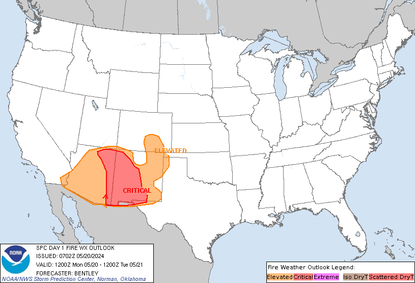
Day 1 Fire Weather Outlook
NWS Storm Prediction Center Norman OK
0158 AM CDT Fri May 10 2024

Valid 101200Z - 111200Z

...Synopsis...
An upper low will meander over the Southwest as a mid-level trough
amplifies over the eastern U.S. today, with northwest flow aloft
prevailing everywhere east of the Mississippi River. As such,
relatively cool conditions will prevail over much of the CONUS, with
significant wildfire-spread potential expected to be limited over
most locations. One exception may be central and eastern portions of
the Florida Peninsula, where 10-15 mph sustained westerly surface
winds, amid 25-35 percent RH, may overspread dry fuels during the
afternoon, warranting Elevated highlights.

A few other areas may also experience localized conditions favorable
for wildfire growth. First, dry and occasionally breezy conditions
may overlap modestly receptive fuels over parts of southeast Arizona
into far southwestern New Mexico, which may promote locally Elevated
fire concerns during the afternoon. Second, dry northerly surface
winds will overspread the northern Plains behind the cold front,
though any wildfire-spread that materializes should be localized
given marginally receptive fuels.

..Squitieri.. 05/10/2024

...Please see www.spc.noaa.gov/fire for graphic product...

Day 2 Fire Weather Outlook
NWS Storm Prediction Center Norman OK
0159 AM CDT Fri May 10 2024

Valid 111200Z - 121200Z

...Synopsis...
A mid-level trough will eject into the Atlantic as a second
mid-level trough ejects into the Southern Plains tomorrow
(Saturday). Surface high pressure will become established over the
eastern U.S., promoting cool conditions while potentially
appreciable rainfall occurs over the southern High Plains. As such,
wildfire-spread concerns will be limited across most of the CONUS.
Guidance consensus does suggest that 15+ mph sustained westerly
surface winds will overspread 10-20 percent RH along the southern
Arizona and New Mexico border area during the afternoon, where
Elevated highlights have been introduced. Otherwise, locally dry or
breezy conditions may prevail over the northern Plains or Florida
Peninsula, where localized wildfire-spread potential may exist.

..Squitieri.. 05/10/2024

...Please see www.spc.noaa.gov/fire for graphic product...
Day 1 Convective Outlook
NWS Storm Prediction Center Norman OK
1257 AM CDT Fri May 10 2024

Valid 101200Z - 111200Z

...THERE IS AN ENHANCED RISK OF SEVERE THUNDERSTORMS FOR NORTH FL
AND A SMALL PART OF SOUTH GA...

...THERE IS A SLIGHT RISK OF SEVERE THUNDERSTORMS FOR NORTHEAST SC
INTO SOUTHEAST NC...

...SUMMARY...
Severe thunderstorms capable of producing damaging wind are possible
today across parts of south Georgia into north Florida. A few severe
storms capable of producing damaging wind and hail are also possible
across northeast South Carolina into southeast North Carolina.

...Synopsis...
An amplified upper-level trough will persist over the eastern CONUS
today. Within the large-scale trough, one shortwave will move
southeastward from the mid MS Valley toward the Southeast, while an
upstream shortwave trough (an attendant weak surface low) will move
across the northern Great Plains and upper MS Valley. In the wake of
extensive early morning convection, a cold front will move southward
across parts of the Southeast and Texas.

...Parts of GA/north FL...
An MCS will likely be ongoing at the start of the period somewhere
across south GA/north FL, supported by favorable
moisture/instability and strong westerly flow aloft. Some
uncertainty remains regarding the timing and intensity of this
system later this morning. While the GA/north FL area saw extensive
convection and related outflow on Thursday, some recovery is
possible prior to the arrival of the MCS, which will support
potential for at least scattered damaging gusts before the MCS moves
offshore.

Depending on the timing and southeastward progression of the MCS,
some redevelopment will be possible along the synoptic cold front
during the afternoon, from southeast AL into southwest GA and the FL
Panhandle vicinity. Deep-layer shear will remain sufficient for
organized convection, and a couple stronger cells/clusters will be
possible, with a threat of isolated hail and damaging gusts.

...Parts of the Carolinas...
With the early-day MCS to the south expected to move quickly
offshore during the morning, there will be some opportunity for a
corridor of moderate destabilization across part of the Carolinas in
advance of the cold front. The favorably timed shortwave trough
approaching from the northwest will support thunderstorm development
along the front, with rather strong deep-layer flow/shear supporting
storm organization. A couple of supercells and/or small bowing
segments will be possible, with a primary threat of damaging gusts
and hail.

...South-central TX...
A cold front that will move through south-central TX is forecast to
slow down through the day, before potentially stalling late tonight.
Elevated convection may develop near/north of the front through the
day. The intensity of any such convection remains uncertain, but
elevated buoyancy may be sufficient to support a strong storm or two
with isolated hail as the primary threat.

...Upper Midwest/Mississippi Valley...
Low-topped convection may develop across parts of MN/WI this
afternoon, in association with the shortwave trough moving
southeastward across the region. Instability will be quite weak due
to limited moisture, but relatively deep mixing and steep low-level
lapse rates could support isolated gusty/damaging winds with the
strongest convection.

..Dean/Squitieri.. 05/10/2024

Day 2 Convective Outlook
NWS Storm Prediction Center Norman OK
1244 AM CDT Fri May 10 2024

Valid 111200Z - 121200Z

...THERE IS A MARGINAL RISK OF SEVERE THUNDERSTORMS ACROSS PORTIONS
OF THE TRANS-PECOS AND FAR WEST TEXAS...

...SUMMARY...
Isolated strong to severe thunderstorms may occur Saturday across
portions of the Trans-Pecos and Far West Texas.

...Synopsis...
Southern-stream upper low is forecast to move eastward across the
Four Corners and into the central Rockies on Saturday, devolving
into an open wave as it does. Moderate mid-level flow will extend
through the base of this wave, expanding eastward across northern
Mexico and into TX. Surface lee troughing is anticipated ahead of
this wave, with some northward expansion of a modified low-level
moisture across the southern High Plains.

A shortwave trough is also expected to progress through the northern
stream, moving from its early morning position over Lower MI
southeastward to the northern Mid-Atlantic by early Sunday morning.
An associated surface low will move just ahead of the parent
shortwave, while an attendant cold front moves across the OH and TN
Valleys by Saturday evening and through the Mid-Atlantic by early
Sunday morning. Isolated thunderstorms are possible along and ahead
of this cold front as it moves across the OH Valley. A few stronger,
convectively augmented gusts are possible within any deeper cores.

...Southern High Plains...
Showers and thunderstorms will likely be ongoing across the region,
within the broad warm-air advection regime ahead of the approaching
shortwave trough. Buoyancy will be modest, but moderate vertical
shear could still support a few updrafts capable of producing small
hail. This area of precipitation will likely persist throughout the
day, likely contributing to a fairly narrow warm sector between the
rain-cooled airmass over much of the TX Panhandle and Permian Basin
and the sharpening lee trough southeast NM and Far West TX. General
expectation is for upper 50s/low 60s dewpoints to advect into the
Trans-Pecos by the late afternoon, contributing to airmass
destabilization amid filtered daytime heating.

Ascent provided by a combination of modest upslope with convergence
along surface lee trough and gradually increasing large-scale
forcing should be enough to initiate a few storms within this
destabilizing airmass. Strong vertical shear should result in
updraft organization/supercells with any robust updrafts. Large hail
and severe gusts are both possible with any supercells. High cloud
bases and modest low-level shear should keep the tornado threat low,
although not zero across much of the region. If a storm can persist
farther east, better low-level flow and low-level moisture will be
in place, contributing to a greater tornado potential. In general,
coverage is expected to remain isolated, precluding the need for
higher severe probabilities with this outlook.

..Mosier.. 05/10/2024