Overnight and Tomorrows forecast 5- 18/19
Tonight – Partly cloudy, Low 55°F. Wind N, 5 to 10 mph.
Tomorrow 5/19- Sunny, High 84°F. Wind N, 5 to 10 mph.
Tomorrow night – Partly cloudy, Low 63°F. Wind N, 5 to 10 mph.

Tonight – Partly cloudy, Low 55°F. Wind N, 5 to 10 mph.
Tomorrow 5/19- Sunny, High 84°F. Wind N, 5 to 10 mph.
Tomorrow night – Partly cloudy, Low 63°F. Wind N, 5 to 10 mph.
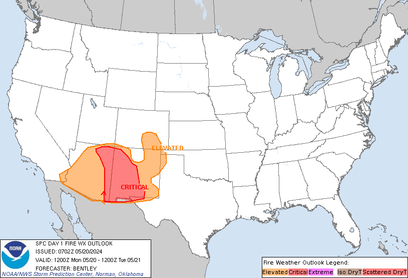
Day 1 Fire Weather Outlook
NWS Storm Prediction Center Norman OK
0217 AM CDT Sun May 19 2024

Valid 191200Z - 201200Z

...Synopsis...
Mid-level troughing will amplify across the western CONUS today.
Meanwhile, a mid-level speed max will accelerate from the Southwest
into the southern Plains. As a result, lee cyclogenesis is
anticipated in the central High Plains. This will lead to dry and
breezy conditions across much of the central CONUS, but especially
across the Southwest and into the southern High Plains. Sustained
winds of 15 to 25 mph are expected across eastern New Mexico and
perhaps into the TX/OK Panhandles and far southeast Colorado where
single digit relative humidity is likely. Fuels across eastern New
Mexico and vicinity are only marginally dry after recent rainfall,
but will continue to dry during the day. Therefore, with low-end
Critical meteorological conditions and marginally dry fuels, an
Elevated delineation is warranted.

..Bentley.. 05/19/2024

...Please see www.spc.noaa.gov/fire for graphic product...
Day 2 Fire Weather Outlook
NWS Storm Prediction Center Norman OK
0218 AM CDT Sun May 19 2024

Valid 201200Z - 211200Z

...CRITICAL FIRE WEATHER AREA FOR SOUTHERN NEW MEXICO...

...Synopsis...
Mid-level flow will start to strengthen on Monday as a subtropical
shortwave trough approaches the region. A very deeply mixed airmass
(near 500mb) will be in place on Monday. Therefore, some of this
stronger mid-level flow should transport to the surface relatively
easily. A large portion of the Southwest and into the central
Rockies will experience Critical meteorological conditions on
Monday. The current Critical outline represents where the driest
fuels are present. Some expansion of this Critical area may be
needed if guidance comes in stronger with winds and/or if fuels dry
significantly in the next 36 hours.

Elsewhere, fire weather concerns remain low at this time due to
moist fuels and high relative humidity.

..Bentley.. 05/19/2024

...Please see www.spc.noaa.gov/fire for graphic product...

PUBLIC SEVERE WEATHER OUTLOOK
NWS STORM PREDICTION CENTER NORMAN OK
0138 AM CDT SUN MAY 19 2024

...Severe thunderstorms expected over parts of the central Plains
later today and tonight...

* LOCATIONS...
  Kansas

* HAZARDS...
  Widespread damaging winds, some hurricane force
  A couple of tornadoes
  Scattered large hail, some baseball size

* SUMMARY...
  Severe thunderstorms are expected across parts of Kansas into
  northwest Oklahoma from late afternoon into mid-evening,
  including the potential for a derecho. Destructive wind swaths
  of 80-100 mph may occur, with localized extreme gusts exceeding
  100 mph possible. Very large hail and a few tornadoes are also
  anticipated.

Preparedness actions...

Review your severe weather safety procedures for the possibility
of dangerous weather today. Stay tuned to NOAA Weather Radio,
weather.gov, or other media for watches and warnings. A watch
means that conditions are favorable for severe thunderstorms
over the next several hours. If a severe thunderstorm warning is
issued for your area, move to a place of safety, ideally in an
interior room on the lowest floor of a sturdy building.

&&

..Edwards.. 05/19/2024
Day 1 Convective Outlook
NWS Storm Prediction Center Norman OK
1256 AM CDT Sun May 19 2024

Valid 191200Z - 201200Z

...THERE IS A MODERATE RISK OF SEVERE THUNDERSTORMS IN SOUTHWEST TO
CENTRAL KS...

...THERE IS A SLIGHT RISK OF SEVERE THUNDERSTORMS SEPARATELY IN
EAST-CENTRAL TO SOUTHEAST FL...

...SUMMARY...
Severe thunderstorms are expected across parts of Kansas into
northwest Oklahoma from late afternoon into mid-evening, including
the potential for a derecho. Destructive wind swaths of 80-100 mph
may occur, with localized extreme gusts exceeding 100 mph possible.
Very large hail and a few tornadoes are also anticipated.

...KS/OK vicinity...
An active severe-weather day is expected during the late afternoon
to mid-evening. Primary changes this outlook are to increase wind
and hail probabilities with above-average guidance agreement
regarding the likelihood of supercells evolving into multiple linear
bows. Significant severe, from both hail and especially wind,
appears likely. How far downstream higher-end intensity threats will
persist towards the lower plains is more uncertain.

General thunderstorm activity is expected to be ongoing within a
low-level warm theta-e advection regime across parts of the central
Great Plains. This will probably persist through much of the morning
into the afternoon, becoming more centered on the Mid-MO Valley to
Upper Midwest. Pronounced differential boundary-layer heating is
expected between this early-day activity and full insolation that
yields hot surface temperatures across the southern High Plains.
With a plume of mid to upper 60s surface dew points overspreading
much of western/central OK into central KS, beneath a plume of very
steep mid-level lapse rates, a strongly unstable airmass will
develop with MLCAPE of 2500-3500 J/kg becoming common.

A strengthening upper-level jet across the Southwest, nosing over
the southern Rockies, should aid in dryline sharpening by late
afternoon. Initial very high-based thunderstorms should form off the
Raton Mesa behind the dryline, while other storms form along the
dryline near the TX Panhandle/western OK border, and in the
north-central KS vicinity near the warm front. The far southern
dryline storms in northwest OK and near the warm front in KS should
remain semi-discrete longer, and will be most capable of producing
very large hail and a couple tornadoes. Between these two corridors,
CAM signals are fairly consistent that a mix of outflow-dominated
clusters with embedded supercells will move east-northeast during
the evening. This includes evolution into linear bowing segments
with forecast soundings, indicating potential for intense
rear-inflow jet development. Given the highly favorable
thermodynamic environment, coupled with the impinging of a mid-level
jetlet across the southern High Plains, this scenario appears
probable.

The southern to central Great Plains low-level jet will strengthen
during the evening, which should result in a large MCS with embedded
bowing structures persisting after dusk. CAM guidance is fairly
quick to indicate diminishing intensity as MLCIN rapidly increases
across much of OK into at least southeast KS. But given the
potential for prolific, organized severe wind swaths upstream, have
increased severe probabilities downstream from the Mid-MO Valley and
deeper into OK.

...Western NE to western/central SD...
Scattered thunderstorm development is expected along the northern
portion of the dryline during the late afternoon to early evening as
a narrow plume of mid to upper 50s surface dew points spreads north.
With a more confined and more modestly buoyant warm-moist sector
relative to KS southward, overall threat should consist of isolated
to scattered large hail and severe wind.

...FL...
Scattered afternoon thunderstorms appear likely to develop ahead of
a slow-moving, positive-tilt shortwave trough over the Southeast.
Best potential for a few supercells should be focused along the
Atlantic Coast sea breeze across parts the central to south
peninsula. Favorable deep-layer shear, in conjunction with large
buoyancy, should foster a predominant threat of large hail, with
isolated damaging winds possible as well.

..Grams/Bentley.. 05/19/2024
Day 2 Convective Outlook
NWS Storm Prediction Center Norman OK
1251 AM CDT Sun May 19 2024

Valid 201200Z - 211200Z

...THERE IS A SLIGHT RISK OF SEVERE THUNDERSTORMS ACROSS
CENTRAL/EASTERN NEBRASKA...NORTHERN KANSAS...SOUTHWEST IOWA AND
NORTHWEST MISSOURI...

...SUMMARY...
Severe thunderstorms are possible across parts of the central Plains
Monday evening into the overnight hours. Additional more isolated
strong to severe storms are possible from the Middle Mississippi
Valley to Lower Michigan through Monday afternoon.

...Synopsis...

A somewhat complex pattern is expected across the Plains to the
upper Great Lakes on Monday. During the morning, an upper shortwave
trough is forecast over the IA vicinity. Convection will likely be
ongoing across parts of the upper MS Valley in association with this
feature as it lifts northeast across WI. Further south, some
guidance is hinting at a possible MCV or outflow over central MO
related to the convective remnants of an intense MCS forecast in the
Day 1/Sun period over KS. Across the central Plains, an area of
broad, enhanced southwesterly mid/upper flow will persist over
NE/KS, though large-scale ascent will remain weak through peak
heating. Capping will likely suppress convection during the
afternoon, and airmass recovery from convection in the Day 1 period
will occur through the daytime hours. A potent lead upper shortwave
trough, emanating from the larger-scale western U.S. upper trough,
will eject into the central High Plains overnight.

At the surface, a broad warm sector with dewpoints in the 60s to
near 70 F will extend east/northeast from the central/southern
Plains to the Mid/Upper MS Valley vicinity. A warm front will lift
north through the day into northern WI/Lower MI. A dryline will
extend south/southwest from northwest OK to southwest TX. Overnight,
surface cyclogenesis will ensue across KS/NE as the upper shortwave
trough approaches the region. A cold front will sharpen and begin to
shift east across central NE/KS late in the period.

...Central Plains to Lower MO Valley...

Severe potential will increase by early Monday evening as the upper
shortwave trough moves into the central Rockies and large-scale
ascent increases. Initial storm development over northeast CO into
southwest NE/northwest KS will pose a risk for damaging gusts and
hail. As a surface low develops east across KS/NE convection will
increase in coverage, particularly over NE. Given timing of
convection (mainly during the nighttime hours) and potential for
linear development as a cold front sharpens and shifts east
overnight, damaging gusts and hail will be the main hazards as
storms approach the MO River by Tuesday morning. The southward
extent of severe potential into KS is a bit uncertain. Strong
capping will likely persist over the southern half of the state.

...Eastern IA into Lower MI...

Convection will likely be ongoing Monday morning. Severe potential
is uncertain during the morning, but any organized storms could pose
a risk of marginally severe hail and locally strong gusts. Guidance
suggests severe potential may increase with eastward extent, and
into the afternoon, from northeast IL into Lower MI as stronger
destabilization will occur ahead of morning activity. Effective
shear magnitudes are forecast to be around 25-30 kt. Meanwhile,
steepening low-level lapse rates, with a mixed boundary layer to
near 850 mb is noted in forecast soundings. Marginal supercells
capable of hail and strong gusts will be possible. If confidence
increases, portions of this area may need higher probabilities in
subsequent outlooks.

...Central MO vicinity...

A somewhat conditional risk is possible across parts of the central
MO vicinity. It is possible that an MCV migrating across the area or
any remnant outflow related to Day 1/Mon activity could focus
thunderstorm development during the late morning into afternoon.
Large-scale ascent will be weak over the area, and deep-layer flow
modest. However, thermodynamic profiles will support marginal hail
and strong gusts if storms develop.

..Leitman.. 05/19/2024
