Overnight and Tomorrows forecast 5- 12/13
Tonight – Overcast. Low 53°F. Wind S, 5 to 15 mph.
Tomorrow 5/13 – Partly cloudy, High 80°F. Wind SSW, 5 to 15 mph.
Tomorrow night – 70% T-storms, Low 53°F. Wind S, 5 to 15 mph.

Tonight – Overcast. Low 53°F. Wind S, 5 to 15 mph.
Tomorrow 5/13 – Partly cloudy, High 80°F. Wind SSW, 5 to 15 mph.
Tomorrow night – 70% T-storms, Low 53°F. Wind S, 5 to 15 mph.
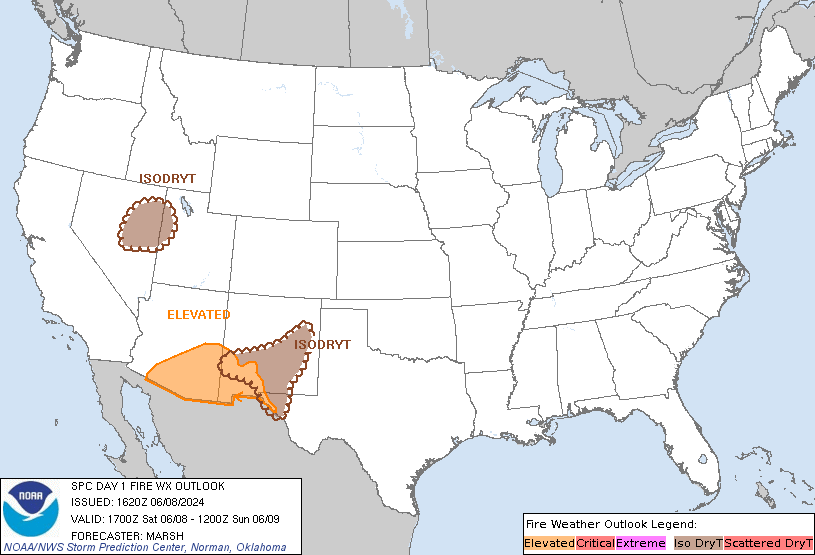
Day 1 Fire Weather Outlook
NWS Storm Prediction Center Norman OK
1153 AM CDT Sun May 12 2024

Valid 121700Z - 131200Z

...CRITICAL FIRE WEATHER AREA FOR PORTIONS OF SOUTHERN NEW MEXICO...

...17z Update...
Morning observations show precipitation and overnight humidity
recoveries are more expansive than previously expected. The backdoor
cold front over the southern High Plains may be slow to mix farther
east due to ongoing cloud cover and weak upslope flow. This suggests
afternoon humidity values should remain somewhat higher than
forecast. As such, the Critical area has been shifted westward and
shrunk to cover areas where drier and windier conditions are more
likely. While confidence in more widespread elevated to critical
fire-weather conditions is not overly high, several hours of gusty
winds and low RH are possible behind the dryline/modifying front
over southern/eastern NM and far west TX within mostly dry fuels.
See the previous forecast for additional information.

..Lyons.. 05/12/2024

.PREV DISCUSSION... /ISSUED 0146 AM CDT Sun May 12 2024/

...Synopsis...
A mid-level trough will traverse the southern Plains today,
encouraging surface lee troughing and accompanying dry and breezy
conditions across portions of southern New Mexico into Far West
Texas this afternoon. 20+ mph sustained westerly surface winds will
coincide with 10-20 percent RH for at least a few hours around
afternoon peak heating, warranting the continuation of
Elevated/Critical highlights. Fire weather highlights for Day 1 have
been modified from Day 2 based on recent observed precipitation.
Nonetheless, the ongoing severe to extreme drought suggests that
fuels should at least be receptive enough to support notable
wildfire-spread potential.

...Please see www.spc.noaa.gov/fire for graphic product...
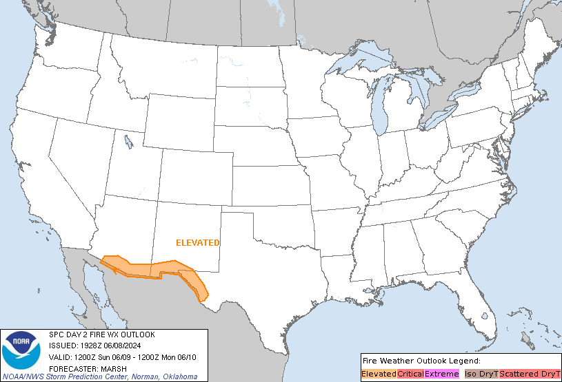
Day 2 Fire Weather Outlook
NWS Storm Prediction Center Norman OK
0206 PM CDT Sun May 12 2024

Valid 131200Z - 141200Z

...NO CRITICAL AREAS...

...19z update...
No changes, fire-weather concerns are low.

..Lyons.. 05/12/2024

.PREV DISCUSSION... /ISSUED 0147 AM CDT Sun May 12 2024/

...Synopsis...
A mid-level trough and associated surface cyclone will progress
toward the Mississippi Valley tomorrow (Monday), encouraging
appreciable rainfall accumulations and/or moist low-level conditions
across the south-central CONUS toward the eastern seaboard. Behind
the surface cyclone, northwesterly low-level flow will transport
relatively dry air southward across the northern Plains to the
southern High Plains. However, guidance consensus suggests that
surface winds will be on the lighter side, which should limit
wildfire-spread potential to local scales.

...Please see www.spc.noaa.gov/fire for graphic product...

Fort Bragg aka Fort Liberty
https://w1.weather.gov/data/obhistory/KFBG.html3:04 pmMay 12, 2024
Day 1 Convective Outlook
NWS Storm Prediction Center Norman OK
1127 AM CDT Sun May 12 2024

Valid 121630Z - 131200Z

...THERE IS A SLIGHT RISK OF SEVERE THUNDERSTORMS THROUGH TONIGHT
FROM SOUTHEAST TX TO SOUTHWEST MS...AND THIS EVENING ACROSS THE
EDWARDS PLATEAU OF TX...AS WELL AS NORTHEAST WI/SOUTHERN U.P. OF
MI...

...SUMMARY...
Large hail, locally damaging winds, and a couple tornadoes are
possible from southeast Texas into Louisiana and southwest
Mississippi through tonight.  Isolated very large hail will be
possible this evening across the Edwards Plateau of Texas.  Damaging
winds and large hail will be possible this evening across northeast
Wisconsin and the southern Upper Peninsula of Michigan.

...East TX/LA/MS through early Monday morning...
A midlevel trough will move slowly eastward from CO/NM to
KS/OK/northwest TX through tonight, with only a weak surface
reflection of the midlevel trough across OK/KS. Farther south, a
warm front will make slow progress northward into southeast TX and
southern LA, though the position of the surface front will be
modulated by the effects of ongoing/slightly elevated convection
moving toward east TX.  This early convection will pose a continued
threat for occasional large hail and damaging outflow gusts into
early afternoon.

By mid afternoon and through late evening, the potential for
near-surface-based storms will increase along the warm front in
southeast TX/southwest LA where low-level shear/hodograph curvature
will be sufficient for supercells with a few tornadoes.  There is
some potential for a larger storm cluster to evolve from the warm
frontal storms by this evening, and storms could persist through the
overnight/early morning hours as far east as MS.

...Edwards Plateau in TX this afternoon/evening...
A couple of supercells will be possible later this afternoon/evening
near the front/dryline triple point roughly in the vicinity of San
Angelo.  MLCAPE > 2500 J/kg, steep midlevel lapse rates and long
hodographs will favor isolated very large hail (up to 2.5 inches in
diameter) as the main threat for a few hours into this evening.

...WI/MI this afternoon through early tonight...
The southeast fringe of the midlevel height falls and a surface cold
front will help focus thunderstorm development after about 21z, and
storms will spread southeastward through late evening/early
overnight.  Afternoon surface temperatures of 75-80 F and dewpoints
of 45-52 F in WI will drive steep low-level lapse rates and SBCAPE
of 500-1000 J/kg, which combined with modest deep-layer shear will
support the potential for high-based storms capable of producing
damaging winds of 60-70 mph and large hail of 1-1.5 inches in
diameter.  The convection will likely become elevated over Lower MI
by late evening/early tonight with some continued potential for
isolated large hail.

...Extreme southwest KS/southeast CO/OK Panhandle this afternoon...
Cloud breaks will allow surface heating and steepening low-level
lapse rates in the vicinity of a weak surface cyclone across extreme
southeast CO.  Deep-layer shear will be weak close to the midlevel
trough, but sufficient buoyancy/minimal inhibition and a vertical
vorticity source will support the potential for a few landspouts
mid-late afternoon.

..Thompson/Thornton.. 05/12/2024
Day 2 Convective Outlook
NWS Storm Prediction Center Norman OK
1237 PM CDT Sun May 12 2024

Valid 131200Z - 141200Z

...THERE IS A SLIGHT RISK OF SEVERE THUNDERSTORMS FROM MUCH OF
EASTERN TEXAS EASTWARD ACROSS THE GULF COAST STATES...

...SUMMARY...
Severe thunderstorms are expected Monday over a large region from
central and east Texas across parts of the Gulf Coast states. The
potential may develop for corridors of significant wind gusts and
very large hail, and a few tornadoes.

...Synopsis...
A shortwave trough will move east from the central and southern
Plains Monday into the Middle to Lower MS Valley through Tuesday
morning, while an upper high remains centered over Cuba. As this
trough moves east, heights will lower gradually across the region,
with a slow flattening of the ridge along the Gulf Coast. Midlevel
winds of 50-60 kt will be common, while stronger 70-90 kt flow at
300 mb shifts northeastward with the shortwave trough from the
ArkLaTex into the OH/TN Valleys.

At the surface, a weak low/trough will develop from northern MO
southward across the ArkLaTex and into southern TX. A very moist air
mass will exist from eastern TX into the lower MS Valley, with
increasing moisture late in the period across southern AL, GA, and
FL as a warm front lifts north. The robust moisture will result in
widespread clouds and precipitation throughout the period, which
will complicate the forecast.

In general, a relatively large area of substantial moisture and
instability will stretch from TX eastward toward the central Gulf
Coast during the day, beneath moderate westerlies aloft which will
enhance deep-layer shear. Stronger low-level shear will be relegated
to the warm front area, from AL into GA and northern FL, with
various corridors of severe potential possible.

...Eastern TX into western GA...
A complex forecast exists for Monday, with multiple areas of
potential within a broad zone, and at various times of the day.
While significant wind and hail will clearly be possible,
predictability is low regarding the precise corridors of enhanced
risk potential.

Early on Monday, storms are expected to be ongoing from MS into AL
and the FL Panhandle, related to warm/moist advection near and north
of a warm front. Some of this activity immediately near the warm
front may have a hail and tornado risk, as instability rapidly
increases in proximity to stronger low-level effective SRH centered
over southern AL.

To the west, early-day storms are also anticipated from the ArkLaTex
into east-central TX, beneath cooler temperatures aloft and where
mid 70s F dewpoints will be in place. This activity may produce
large hail, and eventually grow upscale into larger clusters or an
MCS across eastern TX, LA and western MS through 00Z. Forecast
soundings show ample instability, and moderate mid to high level
winds, but with weak flow below 700 mb, suggesting MCS potential.

Depending on the track of that activity, and the position of any
outflows from the earlier storms farther east, the severe wind and
hail risk may overspread additional areas extending again into AL
and GA. As previously mentioned, potential air mass overturning and
condition of the unstable boundary layer are the main uncertainties,
and therefore the entire region remains in 15% Slight Risk category.
However, corridor(s) of Enhanced Risk may be considered into the day
1 period.

..Jewell.. 05/12/2024
